
New York State Route 440 (NY 440) is a freeway located entirely on Staten Island in New York City. The route acts as a connector between the two segments of New Jersey Route 440, running from the Staten Island community of Richmond Valley in the south to Port Richmond in the north. NY 440 is connected to the two New Jersey segments by the Outerbridge Crossing to the south and the Bayonne Bridge to the north. It is one of several signed New York State routes that are not connected to any others in the state, and one of only two NYS routes that is the middle section of another state's highway bearing the same number. From the Korean War Veterans Parkway to Interstate 278 (I-278), it is known as the West Shore Expressway. North of I-278, it is named the Dr. Martin Luther King Jr. Expressway. NY 440 is the southernmost state route in the state of New York.

Mariners Harbor is a neighborhood located in the northwestern part of New York City's borough of Staten Island. It is bordered by Lake Avenue to the east, Forest Avenue to the south, Richmond Terrace to the north, and Holland Avenue to the west. The northwestern section of Mariners Harbor is often known as Arlington.
Prince's Bay is the name of a neighborhood located on the South Shore of New York City's borough of Staten Island. Prince's Bay is bordered to the north by Huguenot, to the south by the Raritan Bay, and to the west by Pleasant Plains. The neighborhood is represented in the New York State Senate by Andrew Lanza, in the New York State Assembly by Michael Reilly, and in the New York City Council by Joe Borelli.

The term North Shore is frequently applied to a series of neighborhoods within the New York City borough of Staten Island.
Mid-Island is frequently applied to a series of neighborhoods within the New York City borough of Staten Island.

Dongan Hills is a neighborhood located within the New York City borough of Staten Island. It is on the Island's East Shore. Dongan Hills is bounded by Laconia Avenue on the southeast, Jefferson Avenue on the southwest, Richmond Road on the northwest, and Old Town Road to the north. It is adjacent to New Dorp and Grant City to the southwest, Todt Hill to the northwest, Old Town/Concord to the northeast, and South Beach and Midland Beach to the southeast.

Grasmere is the name of a neighborhood located on the East Shore of Staten Island, one of the five boroughs of New York City, New York, United States.

Rosebank is a neighborhood in northeastern Staten Island, one of New York City's five boroughs. It borders Clifton to the north, Arrochar to the south, and the Upper New York Bay to the east.

Travis is a residential and industrial neighborhood in west-central Staten Island, one of the five boroughs of New York City.
Westerleigh is a residential neighborhood in the north-western part of Staten Island in New York City.
Willowbrook is a neighborhood in Staten Island, one of the five boroughs of New York City. It is located in the region of the island usually referred to as Mid-Island, immediately to the south of Port Richmond, to the west of Meiers Corners and Westerleigh, to the north of New Springville, and to the east of Bulls Head.
Graniteville is the name of a neighborhood in Staten Island, one of the five boroughs of New York City.

Concord is a neighborhood located in the borough of Staten Island in New York City, New York, United States.
Elm Park is the name of a small park in the Port Richmond section of Staten Island, one of the five boroughs of New York City, United States. The park is located across Innis Street from Port Richmond High School.

Richmond County, also known as Staten Island is a borough of New York City, New York, United States. Staten Island is the least populated of the five boroughs with 475,000 people but is the third largest in area at 59 sq mi (153 km2).

Old Town is a neighborhood in the New York City borough of Staten Island, located on its East Shore. Old Town was established in August 1661 as part of New Netherland, and was the first permanent European settlement on Staten Island. Originally described as "Oude Dorpe", much of its original territory makes up what is present-day South Beach, with parts of Midland Beach and Dongan Hills. The area was settled by a group of Dutch, Walloon and French Protestants (Huguenots) led by Walloon Pierre Billiou.
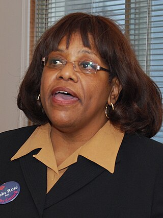
Deborah Rose is a New York City politician. She was the Council member for the 49th district of the New York City Council. She is a Democrat and was the first African American elected to higher office from Staten Island.
Arlington is a neighborhood on the North Shore of Staten Island in New York City. It is a subsection of the Mariners' Harbor neighborhood, located north of the North Shore Branch, and west of Harbor Road. Arlington was given its name by Civil War veteran and resident Moses Henry Leman, in recognition of Arlington National Cemetery.

Steven Matteo is an American politician who served as Council member for the 50th district of the New York City Council. He is a Republican.

