West New Brighton, Staten Island

Last updated
West New Brighton
Pastosa.jpg
A ravioli shop on Forest Avenue in West New Brighton.
Nickname: 
West Brighton
West New Brighton, Staten Island
Location within New York City
Coordinates: 40°38′06″N74°06′43″W / 40.635°N 74.112°W / 40.635; -74.112
Country Flag of the United States.svg  United States
State Flag of New York.svg  New York
City Flag of New York City.svg New York City
Borough Flag of the Borough of Staten Island.svg Staten Island
Community District Staten Island 1 [1]
Area
[2]
  Total3.41 km2 (1.318 sq mi)
Population
 (2011) [2]
  Total20,099
  Density5,900/km2 (15,000/sq mi)
Economics
[2]
   Median income $74,062
ZIP Codes
10310
Area code 718, 347, 929, and 917

West New Brighton (also called West Brighton) is a neighborhood of Staten Island, New York City, situated along the central North Shore. The neighborhood is bordered by New Brighton to the east, Port Richmond to the west, the waters of the Kill Van Kull to the north, and the communities of Sunnyside and Castleton Corners to the south.

Contents

West New Brighton is part of Staten Island Community District 1 and its ZIP Code is 10310. [1] West New Brighton is patrolled by the 120th Precinct of the New York City Police Department.

History

Originally known as "Factoryville," Islanders now commonly refer to the area as West Brighton. Some parts of the neighborhood closer to the shoreline are referred to as "Livingston" and "Randall Manor". This area of Staten Island was originally settled by the Dutch in the 1600s, who were then followed by English settlers. During the American Revolution residents of West Brighton overtly remained loyal to the Crown. Successive waves of immigrants to the US then led to the area becoming populated by the Irish. Today, the neighborhood consists mostly of Irish followed by Germans, Italians, African Americans, and Hispanics.

1874 Beers map West New Brighton. NYPL1515719.tiff
1874 Beers map

The oldest continually operating cricket club in the US was established in West Brighton in 1872, at the site now operated as Walker Park. The Staten Island Cricket Club still has matches there. This is also the site of the first lawn tennis court in the US, built in 1873.

The neighborhood was transformed in the years following World War II. Two large public housing developments were built. The first, the Markham Homes, was originally built to house the families of shipyard & defense workers. The West Brighton Houses followed. Starting in 2004 tenants in The Markham Homes were evicted, so the site might be redeveloped. As of 2007 all tenants had been relocated. While claims had been made that many residents would be able to return into the redeveloped area, few have been able to. [3]

Since the late 90s the area has seen a reduction in some crime rates. Richmond Terrace, which is the main thoroughfare along the Kill Van Kull waterfront, is home to several shipyards and tugboat companies. The area south of Forest Avenue, continues to be home to some of West Brighton's more affluent residents including politicians, lawyers, judges and professionals (particularly in the "Sunset Hill" portion east of Broadway). As of 2014 it was the highest earning census tract on Staten Island. [4]

Politically, West Brighton has been described as a "swing neighborhood" for the borough. With a diverse and representative population, congressional candidates who win the neighborhood tend to also win the borough election. [5]

Demographics

For census purposes, the New York City government classifies New Brighton as part of a larger neighborhood tabulation area called West New Brighton-New Brighton-St. George. [6] Based on data from the 2010 United States Census, the population of West New Brighton-New Brighton-St. George was 33,551, a change of 1,397 (4.2%) from the 32,154 counted in 2000. Covering an area of 1,403.06 acres (567.80 ha), the neighborhood had a population density of 23.9 inhabitants per acre (15,300/sq mi; 5,900/km2). [7] The racial makeup of the neighborhood was 59.1%(8,859) White, 22.2% (10,630) African American, 0.3% (100) Native American, 5% (1,691) Asian, 0% (10) Pacific Islander, 0.4% (123) from other races, and 2.5% (835) from two or more races. Hispanic or Latino of any race were 33.7% (11,303) of the population. [8]

Landmarks

Notable landmarks include the Staten Island Zoo, and Clove Lakes Park and Silver Lake Park along the neighborhood's boundaries. Snug Harbor is also located in nearby Livingston. It holds baseball fields, a children's museum, a Chinese garden, botanical gardens, the Art Lab and the Staten Island Conservatory of Music. St. Peter's Cemetery, which is still properly maintained and is the oldest Roman Catholic cemetery on Staten Island (opened in 1848), is also located here, along with several small abandoned cemeteries in which members of some of the island's founding families are interred.

The former St. Vincent's Medical Center, now known as Richmond University Medical Center is located in West Brighton. While most of the buildings on the RUMC campus date from the late 1960s or more recent, the Garner Mansion goes back to the 19th Century. It at one time was used for the St. Austin's Military School, now defunct.

The Michael J. Mahoney playground is a reminder of a small dose of American History. [9] A son of New York City, and West Brighton, he went off with the US Marines to fight in World War I. He fought in 5 major battles in 1918. Mahoney along with many other Marines, was killed charging up Blanc Mont Ridge, France into the German Maxim machine guns. It is considered by many historians to be the real breaking point of the Germans defensive line before the German homeland. His body was repatriated from his burial plot amongst the thousands of Americans Marines and soldiers buried in World War I memorial cemeteries in France in 1924. His grave is located in St. Peters Cemetery in the family plot. The playground was dedicated in 1940 by the City of New York.

The Calvary Presbyterian Church, Dr. Samuel MacKenzie Elliott House, Gardiner-Tyler House, Kreuzer-Pelton House, and Scott-Edwards House are listed on the National Register of Historic Places. [10]

Police and fire

West New Brighton and the North Shore are patrolled by the 120th Precinct of the NYPD, located at 78 Richmond Terrace. [11] The 120th Precinct ranked 12th safest out of 69 patrol areas for per-capita crime in 2010. [12]

The 120th Precinct has a lower crime rate than in the 1990s, with crimes across all categories having decreased by 83.3% between 1990 and 2022. The precinct reported seven murders, 14 rapes, 118 robberies, 384 felony assaults, 124 burglaries, 338 grand larcenies, and 136 grand larcenies auto in 2022. [13]

Engine 156 Engine 156 @ 412 Bwy 2021 jeh.jpg
Engine 156

West New Brighton is served by the New York City Fire Department (FDNY)'s Engine Co. 156, located at 412 Broadway, [14] [15] and Ladder Co. 79/Battalion 22, located at 1189 Castleton Avenue. [16] [15]

Post office and ZIP Code

West New Brighton is located within the ZIP Codes 10310 and 10301. [17] The United States Postal Service operates the West New Brighton Station at 1015 Castleton Avenue. [18]

Education

Schools

The New York City Department of Education operates the following public schools near West New Brighton: [19]

Library

The New York Public Library (NYPL)'s West New Brighton branch is located at 976 Castleton Avenue. When the branch opened in 1913, it was a sub-branch of the NYPL. The West New Brighton moved to a second location in 1918, and then to its present site in 1933. [23]

Transportation

West New Brighton was served by the West New Brighton station of the Staten Island Railway's North Shore Branch until March 31, 1953. As of 2021, West New Brighton is served by the S40 , S44 , S46 , S48 , S53 , S54 , S90 , S94 , S96 and S98 local buses and the SIM30 express bus. [24]

Notable residents

Related Research Articles

<span class="mw-page-title-main">New Dorp, Staten Island</span> Neighborhood of Staten Island in New York City

New Dorp is a neighborhood on the East Shore of Staten Island, New York City, United States. New Dorp is bounded by Mill Road on the southeast, Tysens Lane on the southwest, Amboy and Richmond Roads on the northwest, and Bancroft Avenue on the northeast. It is adjacent to Oakwood to the southwest, Todt Hill to the northwest, Dongan Hills and Grant City, and Midland Beach and Miller Field to the southeast. New Dorp Beach, bordering to the east, is often listed on maps as a separate neighborhood from Mill Road to the shore of Lower New York Bay, but is generally considered to be a part of New Dorp.

<span class="mw-page-title-main">Tottenville, Staten Island</span> Neighborhood of Staten Island in New York City

Tottenville is a neighborhood on the South Shore of Staten Island, New York City. It is the southernmost settlement in both New York City and New York State, as well as the westernmost in New York City. Tottenville is bounded on three sides by water: the south side abuts the New York Bight while the west and north sides are bordered by the Arthur Kill. Nassau Place, Bethel Avenue and Page Avenue form the neighborhood's eastern border.

<span class="mw-page-title-main">St. George, Staten Island</span> Neighborhood of Staten Island in New York City

St. George is a neighborhood on the northeastern tip of Staten Island in New York City, along the waterfront where the Kill Van Kull enters Upper New York Bay. It is the most densely developed neighborhood on Staten Island, and the location of the administrative center for the borough and for the coterminous Richmond County. The St. George Terminal, serving the Staten Island Ferry and the Staten Island Railway, is also located here. St. George is bordered on the south by the neighborhood of Tompkinsville and on the west by the neighborhood of New Brighton.

<span class="mw-page-title-main">Stapleton, Staten Island</span> Neighborhood of Staten Island in New York City

Stapleton is a neighborhood in northeastern Staten Island in New York City in the United States. It is located along the waterfront of Upper New York Bay, roughly bounded on the north by Tompkinsville at Grant Street, on the south by Clifton at Vanderbilt Avenue, and on the west by St. Paul's Avenue and Van Duzer Street, which form the border with the community of Grymes Hill.

<span class="mw-page-title-main">Midland Beach, Staten Island</span> Neighborhood of Staten Island in New York City

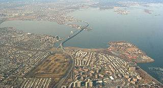
Midland Beach is a neighborhood of Staten Island in New York City. It lies along the east-central coast of the island, in the area known locally as the "Mid-Island, Staten Island" or the "East Shore".

<span class="mw-page-title-main">Port Richmond, Staten Island</span> Neighborhood of Staten Island in New York City

Port Richmond is a neighborhood situated on the North Shore of Staten Island, a borough of New York City. Port Richmond is bounded by Kill van Kull on the north, Jewett Avenue on the east, Forest Avenue on the south, and the Bayonne Bridge on the west. It is adjacent to West New Brighton to the east, Westerleigh to the south, and Elm Park and Mariners Harbor to the west.

<span class="mw-page-title-main">New Brighton, Staten Island</span> Neighborhood of Staten Island in New York City

New Brighton is a neighborhood located on the North Shore of Staten Island in New York City. The neighborhood comprises an older industrial and residential harbor front area along the Kill Van Kull west of St. George. New Brighton is bounded by Kill Van Kull on the north, Jersey Street on the east, Brighton and Castleton Avenues to the south, and Lafayette Avenue and Snug Harbor Cultural Center to the west. It is adjacent to St. George to the east, Tompkinsville to the south, and West New Brighton to the west.

<span class="mw-page-title-main">Mariners Harbor, Staten Island</span>

Mariners Harbor is a neighborhood located in the northwestern part of New York City's borough of Staten Island. It is bordered by Lake Avenue to the east, Forest Avenue to the south, Richmond Terrace to the north, and Holland Avenue to the west. The northwestern section of Mariners Harbor is often known as Arlington.

<span class="mw-page-title-main">North Shore, Staten Island</span>

The term North Shore is frequently applied to a series of neighborhoods within the New York City borough of Staten Island.

Mid-Island is frequently applied to a series of neighborhoods within the New York City borough of Staten Island.

<span class="mw-page-title-main">South Beach, Staten Island</span> Neighborhood of Staten Island in New York City

South Beach is a neighborhood on the East Shore of Staten Island, New York City, situated directly south of the Verrazzano-Narrows Bridge. South Beach is bounded by New York Bay on the southeast, Seaview Avenue on the southwest, Laconia Avenue on the northwest, Reid and McClean Avenues on the north, and Lily Pond Avenue on the northeast. It is adjacent to Midland Beach to the southwest, Dongan Hills and Old Town/Concord to the northwest, and Fort Wadsworth and Rosebank to the northeast.

<span class="mw-page-title-main">Great Kills, Staten Island</span> Neighborhood of Staten Island in New York City

Great Kills is a neighborhood within the borough of Staten Island in New York City. It is located on the island's South Shore, and according to many local geographers, it is the South Shore's northernmost community. It is bordered by Richmondtown to the north, Bay Terrace to the east, Eltingville to the west, and Great Kills Harbor to the south.

<span class="mw-page-title-main">Dongan Hills, Staten Island</span> Neighborhood of Staten Island in New York City

Dongan Hills is a neighborhood located within the New York City borough of Staten Island. It is on the Island's East Shore. Dongan Hills is bounded by Laconia Avenue on the southeast, Jefferson Avenue on the southwest, Richmond Road on the northwest, and Old Town Road to the north. It is adjacent to New Dorp and Grant City to the southwest, Todt Hill to the northwest, Old Town/Concord to the northeast, and South Beach and Midland Beach to the southeast.

Graniteville is the name of a neighborhood in Staten Island, one of the five boroughs of New York City.

<span class="mw-page-title-main">South Ozone Park, Queens</span> Neighborhood of Queens in New York City

South Ozone Park is a neighborhood in the southwestern section of the New York City borough of Queens. It is just north of John F. Kennedy International Airport, between Aqueduct Racetrack to the west and the Van Wyck Expressway to the east. Adjacent neighborhoods include Ozone Park to the west; Richmond Hill to the north; Jamaica, South Jamaica, and Springfield Gardens to the east; and Howard Beach and Old Howard Beach to the southwest.

<span class="mw-page-title-main">Homecrest, Brooklyn</span> Neighborhood of Brooklyn in New York City

Homecrest is a neighborhood situated in the New York City borough of Brooklyn, sometimes considered as part of Sheepshead Bay. It is bordered by Kings Highway to the north, Avenue X to the south, Coney Island Avenue to the west, and Ocean Avenue to the east.

<span class="mw-page-title-main">West Farms, Bronx</span> Neighborhood of the Bronx in New York City

West Farms is a residential neighborhood in The Bronx, New York City. Its boundaries, are: Bronx Park to the north, the Bronx River Parkway to the east, the Cross-Bronx Expressway to the south, and Southern Boulevard to the west. East Tremont Avenue is the primary thoroughfare through West Farms.

<span class="mw-page-title-main">Bay Terrace, Queens</span> Neighborhood of Queens in New York City

Bay Terrace is a neighborhood in the northeastern section of the New York City borough of Queens. It is often considered part of the larger area of Bayside. Bay Terrace overlooks the East River and the approaches to the Throgs Neck Bridge from the Clearview Expressway and Cross Island Parkway. It is bounded on the west by the Clearview Expressway, on the south by 26th and 28th Avenues, to the east by the Little Neck Bay, and to the north by the East River.

<span class="mw-page-title-main">Staten Island Community Board 1</span> Community District in New York, United States

Staten Island Community Board 1 is a local government unit of New York City, encompassing the Staten Island neighborhoods of Arlington, northern Castleton Corners, Clifton Concord, Elm Park, Fort Wadsworth, northern Graniteville, Grymes Hill, Livingston, Mariners' Harbor, northern Meiers Corners, New Brighton, Port Ivory, Port Richmond, Randall Manor, Rosebank, Staten Island, St. George, Shore Acres, Silver Lake, Stapleton, Sunnyside, Tompkinsville, West New Brighton, Westerleigh, and northern Willowbrook. Community Board 1 is essentially the entire area of Staten Island north of the Staten Island Expressway.

References

  1. 1 2 "NYC Planning | Community Profiles". communityprofiles.planning.nyc.gov. New York City Department of City Planning. Retrieved March 18, 2019.
  2. 1 2 3 "West Brighton neighborhood in New York" . Retrieved March 18, 2019.
  3. Nyback, Glenn (2009-03-09). "Some former residents of Staten Island's Markham Gardens not eligible to return". Staten Island Advance. Retrieved 2009-08-22.
  4. "Staten Island's wealthiest enclaves: No. 1 may surprise you". silive. 2016-01-02. Retrieved 2020-11-24.
  5. Michel, Clifford (2020-10-28). "Welcome to West Brighton, the Staten Island Neighborhood that Could Decide the Rose-Malliotakis House Race". THE CITY. Retrieved 2020-11-24.
  6. New York City Neighborhood Tabulation Areas*, 2010, Population Division - New York City Department of City Planning, February 2012. Accessed June 16, 2016.
  7. Table PL-P5 NTA: Total Population and Persons Per Acre - New York City Neighborhood Tabulation Areas*, 2010, Population Division - New York City Department of City Planning, February 2012. Accessed June 16, 2016.
  8. Table PL-P3A NTA: Total Population by Mutually Exclusive Race and Hispanic Origin - New York City Neighborhood Tabulation Areas*, 2010, Population Division - New York City Department of City Planning, March 29, 2011. Accessed June 14, 2016.
  9. "Mahoney Playground" . Retrieved 7 May 2016.
  10. "National Register Information System". National Register of Historic Places . National Park Service. July 9, 2010.
  11. "NYPD – 120th Precinct". www.nyc.gov. New York City Police Department . Retrieved October 3, 2016.
  12. "St. George – DNAinfo.com Crime and Safety Report". www.dnainfo.com. Retrieved October 6, 2016.
  13. "120th Precinct CompStat Report" (PDF). www.nyc.gov. New York City Police Department . Retrieved July 22, 2018.
  14. "Engine Company 156". FDNYtrucks.com. Retrieved March 14, 2019.
  15. 1 2 "FDNY Firehouse Listing – Location of Firehouses and companies". NYC Open Data; Socrata . New York City Fire Department. September 10, 2018. Retrieved March 14, 2019.
  16. "Ladder Company 79/Battalion 22". FDNYtrucks.com. Retrieved March 14, 2019.
  17. "New Brighton, New York City-Staten Island, New York Zip Code Boundary Map (NY)". United States Zip Code Boundary Map (USA). Retrieved March 18, 2019.
  18. "Location Details: West New Brighton". USPS.com. Retrieved March 7, 2019.
  19. "WestBrighton New York School Ratings and Reviews". Zillow. Retrieved March 17, 2019.
  20. "P.S. 018 John G. Whittier". New York City Department of Education. December 19, 2018. Retrieved March 19, 2019.
  21. "I.S. 027 Anning S. Prall". New York City Department of Education. December 19, 2018. Retrieved March 19, 2019.
  22. "P.S. 045 John Tyler". New York City Department of Education. December 19, 2018. Retrieved March 19, 2019.
  23. "About the West New Brighton Library". The New York Public Library. Retrieved March 14, 2019.
  24. "Staten Island Bus Map" (PDF). Metropolitan Transportation Authority. January 2020. Retrieved December 1, 2020.
  25. NY Times June 7th 1914