Woodlawn Heights, also known as Woodlawn, is a predominantly Irish-American working class neighborhood at the very north end of the borough of the Bronx in New York City. It is bounded by McLean Avenue to the north, the Bronx River to the east, Woodlawn Cemetery to the south, and Van Cortlandt Park to the west. Woodlawn Heights remains one of the few areas in New York City that still has young Irish immigrants still arriving to the area en masse.
Baychester is a neighborhood geographically located in the northeast part of the Bronx, New York City. Its boundaries are East 222nd Street to the northeast, the New England Thruway (I-95) to the east, Gun Hill Road to the southwest, and Boston Road to the northwest. Eastchester Road is the primary thoroughfare through Baychester.
Allerton is a working-class neighborhood geographically located in the East Bronx section of the Bronx, New York City. It is named in honor of Daniel Allerton, an early Bronx settler who purchased and farmed this area with his wife Hustace. It consists of two subsections called Bronxwood and Laconia. Its boundaries, starting from the north and moving clockwise, are Adee Avenue, Boston Road, and Gun Hill Road to the northeast; the IRT Dyre Avenue Line to the east; Waring Avenue to the south; and Bronx River Parkway to the west. White Plains Road and Boston Road are the primary thoroughfares through Allerton.

Fordham Manor is a neighborhood located in the western Bronx, New York City. Fordham is roughly bordered by East 196th Street to the north, the Harlem River to the west, Fordham Road to the south, and Southern Boulevard to the east. The neighborhood's primary thoroughfares are Fordham Road and Grand Concourse.

Bedford Park is a residential neighborhood in the northwest Bronx, New York City, adjacent to the New York Botanical Garden. Its boundaries, starting from the north and moving clockwise, are: Mosholu Parkway to the north, Webster Avenue to the east, East 196th Street to the south, and Jerome Avenue to the west.
East Tremont is a residential neighborhood located in the West Bronx, New York City. From the north and moving clockwise, it is bounded by East 180th Street, Southern Boulevard, the Cross-Bronx Expressway and Third Avenue. East Tremont Avenue is the primary thoroughfare through the neighborhood.

Bronx Community Board 1 is a local government unit of the city of New York, encompassing the neighborhoods of Mott Haven, Melrose, and Port Morris in the borough of the Bronx. It is delimited by the East River, East 149th Street, and Prospect Avenue on the east, East 161st Street, East 159th Street, and East 149th Street on the north, and the Harlem River and Bronx Kill on the west and south.

Bronx Community Board 2 is a local government unit of the city of New York, encompassing the neighborhoods of Hunts Point and Longwood in the borough of the Bronx. It is delimited by the Bronx River on the east, Westchester Avenue, East 167th Street, and East 169th Street on the north, Prospect Avenue and East 149th Street to the west, and the East River on the south.

University Heights is a neighborhood of the West Bronx in New York City. Its boundaries, starting from the north and moving clockwise, are: West Fordham Road to the north, Jerome Avenue to the east, West Burnside Avenue to the south and the Harlem River to the west. University Avenue is the primary thoroughfare in University Heights.
Kingsbridge Heights is a residential neighborhood geographically located in the northwest Bronx, New York City. Its boundaries are Van Cortlandt Park to the north, Jerome Avenue to the east, Kingsbridge Road to the south, and the Major Deegan Expressway to the west. Sedgwick Avenue is the primary thoroughfare through Kingsbridge Heights.

Bronx Community Board 3 is a local government unit in the New York City borough, of the Bronx, encompassing the neighborhoods of Crotona Park East, Claremont, Concourse Village, Melrose, and Morrisania. It is delimited by Sheridan Boulevard to the east, the Cross Bronx Expressway and Crotona Park North to the north, Park Avenue and Webster Avenue to the west, and East 159th Street and East 161st Street to the south.

Bronx Community Board 4 is a local government unit of the City of New York, encompassing the neighborhoods of Mount Eden, Highbridge and Concourse. It is delimited by Webster Avenue and Park Avenue to the east, Washington Bridge and the Cross Bronx Expressway to the north, the Harlem River to the west, and East 149th Street to the south.

Bronx Community Board 6 is a local government unit of the city of New York, encompassing the neighborhoods of Bathgate, Belmont, East Tremont, and West Farms as Bronx Community District 6. It is delimited by Bronx Park to the east and north, Webster Avenue to the west, and Crotona Park North and the Cross Bronx Expressway to the south.

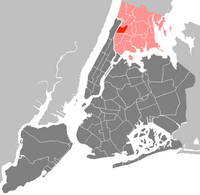
Bronx Community Board 7 the governing body of Bronx Community District 7, a local government unit of the city of New York. The Community District encompasses the neighborhoods of Bedford Park, Fordham, Jerome Park, Kingsbridge Heights, Norwood, and University Heights. It is delimited by the New York-New Haven Railroad, Webster Avenue, East Fordham Road, Jerome Avenue, and West 183rd Street to the east, Jerome Avenue, West Gun Hill Road, Goulden Avenue, Kingsbridge Road, West 225th Street, and the Harlem River to the west, West Gun Hill Road, Jerome Avenue, Bainbridge Avenue, and East 211th Street to the north and Hall of Fame Terrace to the south.

Bronx Community Board 9 is a local government unit of the city of New York, encompassing the neighborhoods of Castle Hill, Parkchester, Soundview, Harding Park, Bronx River, Clason Point and Unionport. It is delimited by Westchester Creek to the east, Sheridan Boulevard to the west, the Cross Bronx Expressway and East Tremont Avenue to the north and the Bronx River and the East River to the south.

Bronx Community Board 10 is a local government unit of the New York City borough of the Bronx, encompassing the neighborhoods of City Island, Co-op City, Pelham Bay, Throggs Neck and Westchester Square. It is delimited by the Hutchinson River and Pelham Bay Park to the east, New England Thruway, Hutchinson River Parkway, and Westchester Creek to the west, the Bronx/Westchester County Line to the north and the East River to the south.

Bronx Community Board 12 is a local government unit of the New York City borough of the Bronx, encompassing the neighborhoods of Edenwald, Wakefield, Williamsbridge, Woodlawn Heights, Fish Bay, Eastchester, Olinville and Baychester.
Morris Heights is a residential neighborhood located in the West Bronx. Its boundaries, starting from the north and moving clockwise are: West Burnside Avenue to the north, Jerome Avenue to the east, the Cross-Bronx Expressway to the south, and the Harlem River to the west. University Avenue is the primary thoroughfare through Morris Heights.

Pelham Parkway is a working- and middle-class residential neighborhood geographically located in the center of the Bronx, a borough of New York City in the United States. Its boundaries, starting from the north and moving clockwise are: Waring Avenue to the north, the IRT Dyre Avenue Line tracks to the east, Neill Avenue to the South, and Bronx River Parkway to the west. White Plains Road is the primary commercial thoroughfare through Pelham Parkway. The neighborhood is named after Pelham Parkway, a major west–east parkway that travels through the East Bronx.

Belmont is a primarily residential neighborhood in the Bronx in New York City. Its boundaries are Fordham Road to the north, Bronx Park to the east, East 181st Street to the south, and Third Avenue to the west. These boundaries give the neighborhood a crescent-like shape. The neighborhood is noted for its "close-knit community" and "small-town feel", and as a result of its cultural history and wide array of Italian businesses, is widely known as the "Little Italy of the Bronx". Arthur Avenue, noted for its local restaurants and markets, is its primary thoroughfare.