
Chittoor is a city and district headquarters in Chittoor district of the Indian state of Andhra Pradesh. It is also the mandal and divisional headquarters of Chittoor mandal and Chittoor revenue division respectively. The city has a population of 153,756 and that of the agglomeration is 175,647.
Khammam is the city in Khammam district of the Indian state of Telangana. It is the fourth largest city in the state. It is the headquarters of the Khammam district and Khammam mandal also. It is located about 193 kilometres (120 mi) east of the state capital, Hyderabad, 61 kilometres (38 mi) from Suryapet, 120 kilometres (75 mi) from Warangal and also it is located about 121 kilometres (75 mi) North of the Andhra Pradesh state capital, Amaravathi. The river Munneru flows on the western side of the city. As of 2011 census of India, Khammam urban agglomeration has a population of 313,504. However, on 19 October 2012, the civic body of Khammam was upgraded to a municipal corporation. Post- upgradation to corporation, the population of Khammam was approximated to be 3,07,000.
Secunderabad, also spelled as Sikandarabad, is a twin city of Hyderabad and one of the six zones of the Greater Hyderabad Municipal Corporation (GHMC) in the Indian state of Telangana. It is the headquarters of the South Central Railway zone. Named after the Mir Akbar Ali Khan Sikander Jah, Asaf Jah III, Nizam of the Asaf Jahi dynasty, Secunderabad was established in 1806 as a British cantonment. Although both the cities are together referred to as the twin cities, Hyderabad and Secunderabad have different histories and cultures, with Secunderabad having developed directly under British rule until 1948, and Hyderabad as the capital of the Nizams' princely state of Hyderabad. Since 1956, the city has housed the Rashtrapati Nilayam, the winter office of the president of India.

Kurnool is a city in the state of Andhra Pradesh, India. It formerly served as the capital of Andhra State (1953–1956). The city is often referred to as "The Gateway of Rayalaseema". Kurnool is also known as The City of Gem Stones. It also serves as the district headquarters of its Kurnool district. As of 2011 census, it is the fifth most populous city in the state with a population of 484,327. It is located on the banks of the Tungabhadra river. Although the area has been inhabited for thousands of years, modern Kurnool was founded in the 16th century CE with the construction of the Konda Reddy Fort.

Nizamabad or Induru is a city in the Indian state of Telangana. It is governed by municipal corporation and is the headquarters of the Nizamabad district. Although previously part of Hyderabad State and then Andhra Pradesh state, Nizamabad became a part of the newly formed state of Telangana by the Andhra Pradesh Reorganisation Act, 2014. It is located about 186 kilometres (116 mi) north of the state capital, Hyderabad.
Sangareddy, formally Sangareddipet is a city and district headquarters of the Sangareddy district in the Indian state of Telangana. It was named after the ruler Sanga, who was the son of Rani Shankaramba, a ruler of Medak during the Nizam era. It is the largest city in the Sangareddy district and the sixth largest city in the state.
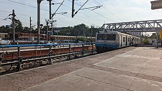
The Hyderabad Multi-Modal Transport System, commonly abbreviated as MMTS, is a suburban rail system in Hyderabad, India. A joint venture of the Government of Telangana and the South Central Railway, it is operated by the latter. The 90-kilometre (56 mi) system operates to cater the city of Hyderabad and the neighbouring suburban areas connecting Hyderabad, Secunderabad, Falaknuma, Lingampally, Medchal and Umdanagar with a total of 133 MMTS services. Currently 86 MMTS services are being operated due to the effect of COVID-19.

Sitaphal Mandi is one of the old suburbs of Secunderabad City in the state of Telangana, India. It is located close to Secunderabad Railway Station and is surrounded by Osmania University in the east, Warasiguda in the south, Secunderabad in the west and Tarnaka in the north. Sitaphalmandi is located about 1.5 km from Secunderabad.

Nizamabad district is a district located in the north-western region of the Indian state of Telangana. The city of Nizamabad is the district headquarters. The district share boundaries with Jagtial, Sircilla, Nirmal, Kamareddy districts and with Nanded district of the state boundary of Maharashtra.

Ranga Reddy district is a district in the Indian state of Telangana. The district headquarters is located at Kongara Kalan Village, Ibrahimpatnam Mandal,. The district was named after the former deputy chief minister of the United Andhra Pradesh, K. V. Ranga Reddy. The district shares boundaries with Nalgonda, Yadadri Bhuvanagiri, Hyderabad, Medchal–Malkajgiri, Nagarkurnool, Mahabubnagar, Sangareddy and Vikarabad districts.

Hyderabad, the capital and largest city of Telangana, features a growing transportation infrastructure that includes a network of roads, railways, and a developing rapid transit system. These transportation systems play a crucial role in connecting the city's residents and facilitating efficient travel within Hyderabad and its surrounding areas. Furthermore, Hyderabad serves as a significant center for transportation and logistics, playing a crucial role in facilitating the seamless movement of goods and services within the state.

Koti is a locality in the city of Hyderabad, Telangana, India. It is one of the best-known commercial Old Suburbs of Hyderabad. There are two areas in the vicinity: King Koti and Ram Koti.

Pakala is a town in Tirupati district of the Indian state of Andhra Pradesh. It is the mandal headquarters of Pakala mandal. It comes under Tirupati revenue division.

Kanigiri is a town in Prakasam district of the Indian state of Andhra Pradesh. It is a municipality and the headquarters of Kanigiri mandal in Kanigiri revenue division.

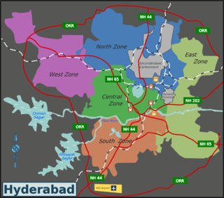
Greater Hyderabad Municipal Corporation (GHMC) is the civic body that oversees Hyderabad, the capital and largest city of the Indian state of Telangana. It is the local government for the city of Hyderabad. It is one of the largest municipal corporations in India with a population of 7.9 million and an area of 650 km2.

Miyapur, located 22.5 kilometres (14.0 mi) northwest of Hyderabad, is part of Greater Hyderabad and administered by GHMC and developed by HMDA. Transportation is managed by UMTA.

Secunderabad Junction is an NSG–1 category Indian railway station in Secunderabad railway division of South Central Railway zone. It is the major Railway Junction in the city of Hyderabad, Telangana, India. It is ones of the busiest railway station in South India and one of the most important hubs in the country and a commuter rail hub in the Hyderabad urban area. Built in 1874 by the Nizam of Hyderabad during the British era, it was the main station of Nizam's Guaranteed State Railway until the Kacheguda railway station opened in 1916. The station was taken over by Indian Railways in 1951, when NGSR was nationalized. Its main portico and concourse are influenced by Nizamesque architecture. The station, which resembles a fort, is a tourist attraction in the twin cities of Hyderabad and Secunderabad.
Archbishop Samineni Arulappa, also known as S Arulappa, was an Indian Catholic clergyman who served as the Archbishop of Hyderabad from December 1971 through January 2000. The youngest priest to be consecrated to such a high office, he was also the longest-serving Catholic archbishop in India. He was also the first archbishop who had the honour of being consecrated by Pope Paul VI in Rome.
Secunderabad Cantonment Board is the civic administrative agency of Secunderabad cantonment area. Geographically, it lies in the twin cities of Hyderabad-Secunderabad. Secunderabad Cantonment Board is India’s second largest cantonment board, after Bathinda Cantonment. There are eight civilian wards in Secunderabad Cantonment Board, with a population of four lakh. Being primarily a military area, the Secunderabad cantonment comes under the administrative purview of the union defence ministry of the government of India. It is overseeing an area of 71.23 km2 (27.50 sq mi), where there are several military camps. Secunderabad Cantonment has a huge land bank, which has been protected since the British era.
Andhra Pradesh is well connected with various destinations in India, as well as other countries. It has road, rail, airways. With a long coast of Bay of Bengal and many sea ports, it flourishes in sea trade as well. The state has one of the largest railway junctions at Vijayawada and Visakhapatnam Port being one of the largest cargo handling seaport.

