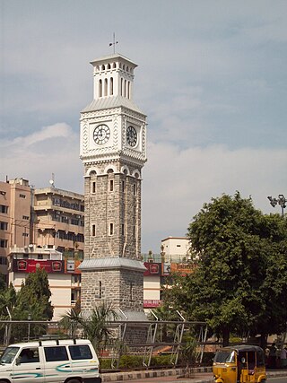
Secunderabad, also spelled as Sikandarabad, is a twin city of Hyderabad and one of the six zones of the Greater Hyderabad Municipal Corporation (GHMC) in the Indian state of Telangana. It is the headquarters of the South Central Railway zone. Named after the Mir Akbar Ali Khan Sikander Jah, Asaf Jah III, Nizam of the Asaf Jahi dynasty, Secunderabad was established in 1806 as a British cantonment. Although both the cities are together referred to as the twin cities, Hyderabad and Secunderabad have different histories and cultures, with Secunderabad having developed directly under British rule until 1948, and Hyderabad as the capital of the Nizams' princely state of Hyderabad.

Nizamabad, also known as Induru, is a city in the Indian state of Telangana. Nizamabad is a major urban agglomeration and third largest city in the state. It is governed by municipal corporation and is the headquarters of the Nizamabad district. Although previously part of Hyderabad State and then Andhra Pradesh state, Nizamabad became a part of the newly formed state of Telangana by the Andhra Pradesh Reorganisation Act, 2014. It is located about 186 kilometres (116 mi) north of the state capital, Hyderabad.
Kukatpally is a suburb located in north western part of Hyderabad in the Indian state of Telangana. It is the headquarters of Balanagar mandal in Malkajgiri revenue division of Medchal-Malkajgiri district. It was a municipality prior to its merger into the Greater Hyderabad Municipal Corporation, now it is the headquarters of "North Zone of GHMC".
Malkajgiri also known as Mallikarjuna Giri is a suburb of Hyderabad, Telangana, India. It is located in Medchal–Malkajgiri district and also Sub-District in Medchal District is the headquarters of Malkajgiri mandal in Malkajgiri revenue division. Erstwhile Malkajgiri Major Grampanchayat was upgraded to a municipality in 1965 and became a municipal corporation in 1985. It was merged into the Greater Hyderabad Municipal Corporation in 2007. It was a part of Ranga Reddy district before the re-organisation of districts in 2016.
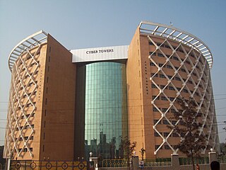
Madhapur is a suburb of Hyderabad, India. It is noted as a centre of information technology activity. The heart of this area is called HITEC City which has the highest concentration of IT/ITES establishments in the city. Located in Ranga Reddy district of Telangana, It is administered as Ward No. 107 of Greater Hyderabad Municipal Corporation.

Uppal is a suburb in Eastern Hyderabad, Telangana, India. It is the mandal headquarters of Uppal mandal in Keesara revenue division in Medchal-Malkajgiri district. It forms Circle No.2 in the L. B. Nagar Zone of Greater Hyderabad Municipal Corporation. There are four wards i.e., Chilukanagar (7), Habsiguda (8), Ramanthapur (9) and Uppal (10) in this circle.
Nacharam is a neighbourhood of Hyderabad in the Indian state of Telangana. It falls under Uppal Mandal. It forms Ward No. 6 of Greater Hyderabad Municipal Corporation.

Saroornagar is a suburb in Hyderabad. It is located in the Rangareddy district of Indian state of Telangana. It is located in Saroornagar mandal of Kandukur revenue division. This circle (5) comes under L. B. Nagar of Greater Hyderabad Municipal Corporation. There are five wards in this circle namely Saroornagar (19), Rama Krishna Puram (20), Kothapet (21), Chaitanyapuri (22) and Gaddiannaram (23).

Hayathnagar is a busy residential locality Hyderabad in Ranga Reddy district of the Indian state of Telangana, pincode 500070 & 501505. It is Mandal headquarter of Hayathnagar mandal of Hayathnagar revenue division. Hayathnagar forms circle No 3 in Greater Hyderabad Municipal Corporation. There are four wards i.e Nagole (11) Mansoorabad (12), Hayathnagar (13) and B. N. Reddy Nagar (14) in this circle. It lies on National Highway 65.

Greater Hyderabad Municipal Corporation (GHMC) is the civic body that oversees Hyderabad, the capital and largest city of the Indian state of Telangana. It is the local government for the city of Hyderabad. It is one of the largest municipal corporations in India with a population of 7.9 million and an area of 650 km².
Mallapur is also known as Mallapuram before (2000's) is a neighbourhood in Hyderabad in the Indian state of Telangana. It falls under Uppal mandal of Medchal-Malkajgiri district. It is administered as Ward No. 5 of Greater Hyderabad Municipal Corporation.
Chanda Nagar is a suburb of Hyderabad and is located close to Lingampally and Miyapur. It is administered as Ward No. 110 of Greater Hyderabad Municipal Corporation.

Khairatabad is a neigbbourhood in Hyderabad, Telangana, India. It is a mandal in the Secunderabad Revenue division of Hyderabad District. This is a Zone in the Greater Hyderabad Municipal Corporation. There are five circles in this zone namely Mehdipatnam (12), Karwan (13), Goshamahal (14), Khairatabad (17) and Jubilee Hills (18). There are four wards under this Khairatabad circle, they are Khairtabad (91), Somajiguda (97), Ameerpet (98) and Sanathnagar (100).

Hyderabad is located in central Telangana and is spread over an area of 2,500 km2. The city lies in the Deccan Plateau and rises to an average height of 536 m above the sea level. The city lies at 17.366° N latitude and 78.476° E longitude.
Moosapet is a neighbourhood in Hyderabad, India, And also a part of Greater Hyderabad. The suburb is 3 km (1.9 mi) from KPHB Colony and 5 km (3.1 mi) from Madhapur. Kukatpally Y junction is located in this area. It is administered as Ward No. 117 of the Greater Hyderabad Municipal Corporation.

Nizampet is a satellite city of Hyderabad and a municipal corporation situated in Bachupally mandal, Medchal-Malkajgiri district of Telangana, India. It is administered as Nizampet Municipal Corporation.

Erragadda is a developing commercial and residential area in the west zone of Hyderabad, Telangana, India. It is home to the ECE Industries, an electrical enterprise. Popular landmarks are the Gokul theater and St. Theresa's Hospital which was constructed in the 1980s or 1970s respectively. It is administered as Ward No. 101 of Greater Hyderabad Municipal Corporation. The corporator is Shaikh Tajuddin.
Vidyanagar is a Locality of Hyderabad, Telangana, India. It formed Ward No. 86 of Greater Hyderabad Municipal Corporation.

Habsiguda is a neighbourhood in Hyderabad, Telangana, India. It is located at the eastern end of the city between Tarnaka and Uppal. It forms Ward No. 7 of Greater Hyderabad Municipal Corporation.
Srinagar colony is an important commercial and residential area in the western part of Hyderabad, Telangana, India. It formed Ward No. 104 of Greater Hyderabad Municipal Corporation in 2009.

