
Choutuppal is a census town in Yadadri Bhuvanagiri district of the Indian state of Telangana. It is located in Choutuppal mandal of Choutuppal division. Its part of Hyderabad Metropolitan Development Authority. 49 km from Hyderabad.
Pharenda, or Anandnagar, is a city in the Maharajganj district of the province of Uttar Pradesh in northern India. It is located approximately 44 kilometres north of Gorakhpur near the border with Nepal. District of Pharenda is Maharajganj. This is situated on the Buddhist Circuit which is built from Sarnath to Lumbini. It lies on NH-24 and near NH 29. It is about 45 km from Gorakhpur, 40 km from Siddharthnagar, 30 km from Maharajganj and 55 km from Sonauli Indo-Nepal border. This place is named after Seth Anandram Jaypuriya. There is closed sugar Mill which was started in about 1935 and closed in 1995. Near Anand Nagar there is a temple is Durga devi mandir, popularly known as Lehara Devi mandir.

Jatani is a town and a major sub-urban area of Bhubaneswar, the state capital of Odisha. It is also a municipality in Khordha district in the Indian state of Odisha. Jatani, also known as Khurda Road Junction in Indian Railways parlance, acts as an important railway junction between the main railroads running between Kolkata and Chennai, with diversions to the Hindu pilgrimage city of Puri, and to Balangir, passing through the districts of Nayagada, Daspalla, Phulbani, Boudh and Sonepur the vast tribal hinterland of Odisha. It has emerged as a commercial hub with a number of educational and other institutions. It is home to Premier Public Institutes like NISER and IIT-Bhubaneswar and ICAR- International Centre for Foot and Mouth Disease (ICFMD). Jatni is famous for its celebration of the festival of Ganesh Chaturthi.
Sembakkam is a neighborhood in the city of Tambaram, situated within the Chennai Metropolitan Area, Tamil Nadu, India.
Gajwel, officially Gajwel–Pragnapur, is a town and a municipality in Siddipet district of the Indian state of Telangana. The jurisdiction of the civic body is spread over an area of 49.00 km2 (18.92 sq mi). Gajwel, located about 53 km from Hyderabad on the Rajiv highway, is one of the fastest-developing towns in Telangana. It serves as a major political center and is the home constituency of the former Chief Minister of Telangana, K. Chandrashekar Rao. Gajwel has seen development in various sectors, including infrastructure projects like the Outer Ring Road (ORR) construction. The ORR, spanning approximately 21.92 kilometers, connects Gajwel with cities such as Hyderabad, Nagpur, Mumbai, Pune, and Nizamabad, improving connectivity and facilitating smoother travel.
Gudur, Kurnool district is a Nagar Panchayath and a Mandal HQ of Gudur Mandal in Kurnool district in the state of Andhra Pradesh in India.

The Outer Ring Road, officially known as Nehru Outer Ring Road and abbreviated as, O.R.R., is a 158-kilometre (98 mi), eight-lane ring road expressway encircling Hyderabad, capital of the Indian state of Telangana. The expressway is designed for speeds up to 100 kilometres per hour (62 mph), which later increased to 120 kilometres per hour (75 mph). A large part, 124 kilometres (77 mi) of the 158 kilometres (98 mi) was opened by December 2012.

Gachibowli is a neighbourhood in Hyderabad, Telangana, India, located in the Serilingampally mandal of the Rangareddy district. It is situated about 5 km away from HITEC City, another IT hub. Gachibowli is home to numerous tech companies and residential units. It has a vast area and is dotted with rocky surface and hillocks all around.

Nizampet is a satellite city of Hyderabad and a municipal corporation situated in Bachupally mandal, Medchal-Malkajgiri district of Telangana, India. It is administered as Nizampet Municipal Corporation.

Amberpet is one of the oldest suburbs of Hyderabad, India. Amberpet lies adjacent to the famous Osmania University. It is also a Mandal in Hyderabad District. Its area stretches from Kachiguda to Ramanthapur in the East, and from 6 NO TO MALAKPET in the South. One of the oldest area of, Hyderabad, India.

Thenhipalam is a census town and a panchayat in Tirurangadi taluk in Malappuram district of Kerala, India, with a population of 27,273 as per 2001 census, consisting of 13,293 males and 13,980 females. Tenhipalam forms a portion of the Malappuram metropolitan area as of 2011 Census. University of Calicut, the first university in the Malabar region, is located north-west part of the Panchayat. 'Chelari' is the main commercial place in Tenhipalam panchayat while 'Panambra' is considered the headquarters of the panchayat. The small town between Chelari and the university is called Kohinoor.
Poothakkulam, also known as Bhoothakkulam, is a village in Kollam district in the state of Kerala, India. The village is located 3.9 km away from Paravur, 11.4 km from Varkala and 23 km from Kollam. In 2011, it had a population of 628,451 residents. The village covers an area of 16.56 km2.

P. V. Narasimha Rao Expressway is an 11.6 km long elevated road connecting the Hyderabad International Airport with Mehdipatnam. Chief minister Y. S. Rajasekhara Reddy laid the foundation stone for the project. It was opened to the traffic at the end points on 19 October 2009. The entry for cyclists, two and three-wheelers, three and four-wheeled seven seater and goods vehicles is prohibited.
Suchitra Junction or Suchitra Center or Suchitra cross roads is a suburb of Hyderabad, Telangana, India, on the Bowenpally-Medchal Road.
Tukkuguda is a municipality in Rangareddy district, Telangana, India. It falls under Maheswaram mandal.

Nagaram, formally known as Naagavaram, is a suburb of Hyderabad and a municipality in Telangana, India. And it also the largest Revenue Village falls under Keesara mandal of Medchal-Malkajgiri district. Due to its proximity to ECIL Company, Secunderabad and Eastern IT/SEZ of Hyderabad Pocharam, it is emerging as a major residential location in Hyderabad.
Koyalgudem is a village in Choutuppal mandal, Yadadri Bhuvanagiri district in Telangana, India. This village popular for its 100% cotton and silk handloom (Ikat) manufacturing and exports. This village is separated from Ellambavi, a new gram panchayath was formed in 2018.
Bandlaguda Jagir is a satellite city of Hyderabad and a municipal corporation in Rangareddy district, Telangana, India. It Falls Under Gandipet mandal of Rajendranagar revenue division. It recently upgraded to a municipal corporation.
Mannivakkam is a town near Chennai Metropolitan City in the Indian state of Tamil-Nadu India. Mannivakkam lies between Vandalur and Mudichur, 7.5 kilometers from Tambaram and 2 kilometers from Vandalur. Mannivakkam is listed in CMDA's Chennai Metropolitan Area (CMA) master plan as village number 1 under Kattankolathur Panchayat Union. The town is well connected with industrial areas such as Oragadam and Sriperambadur by road and also with Maraimalai Nagar and Mahindra World City, Chennai by road as well as suburban railways.
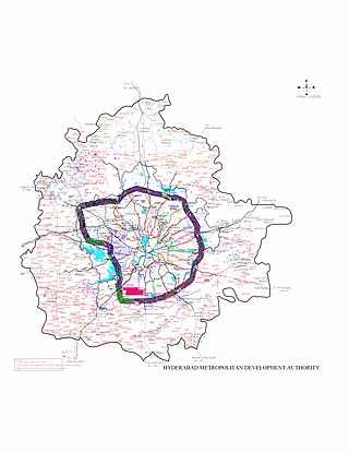
Hyderabad Metropolitan Region is the metropolitan area covered by the city of Hyderabad in the Indian state of Telangana. The entire region is spread over the districts of Hyderabad District, Bhuvanagiri, Medchal-Malkajgiri, Ranga Reddy, Sangareddy, Medak, and Siddipet. Under the jurisdiction of Hyderabad Metropolitan Development Authority, it covers an area of 7,257 km2 (2,802 sq mi) and has a population of 10.7 million people.