The Indian Astronomical Observatory (IAO) is a high-altitude astronomy station located in Hanle, India and operated by the Indian Institute of Astrophysics. Situated in the Western Himalayas at an elevation of 4,500 meters (14,764 ft), the IAO is one of the world's highest located sites for optical, infrared and gamma-ray telescopes. It is currently the tenth highest optical telescope in the world. It is India's first dark-sky preserve.

Ladakh is an administrative territory of India that has been under its control since 1947. The geographical region of Ladakh union territory is the highest altitude plateau region in India, incorporating parts of the Himalayan and Karakoram mountain ranges and the upper Indus River and valley.
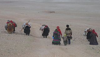
The Changtang is a part of the high altitude Tibetan Plateau in western and northern Tibet extending into the southern edges of Xinjiang as well as southeastern Ladakh, India, with vast highlands and giant lakes. From eastern Ladakh, the Changtang stretches approximately 1,600 kilometres (990 mi) east into Tibet as far as modern Qinghai. The Changtang is home to the Changpa, a nomadic Tibetan people. The two largest settlements within the Tibetan Changtang are Rutog Town the seat of Rutog County and Domar Township the seat of Shuanghu County.

Tourism is one of an economic contributor to the union territory of Ladakh in Northern India. The union territory is sandwiched between the Karakoram mountain range to the north and the Himalayas to the south and is situated at the height of 11,400 ft. Ladakh is composed of the Leh and Kargil districts. The region contains prominent Buddhist sites and has an ecotourism industry.
Rupshu is a high elevation plateau and valley and an eponymous community development block in southeast Ladakh. It is between the Startsapuk Tso and Tso Moriri, and west of Mahe.
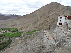
Hanle is a large historic village in the Indian union territory of Ladakh. The revenue village of Hanle comprises six hamlets — Bhok, Dhado, Punguk, Khuldo, Naga and Tibetan Refugee habitation —within 1073 sq km Changthang Wildlife Sanctuary in Changthang plateau. It is the site of the 17th-century Hanle Monastery (gompa) of the Drukpa Kagyu branch of Tibetan Buddhism. Hanle is located in the Hanle River valley on an old branch of the ancient Ladakh–Tibet trade route. Hanle is the home of Hanle observatory, the tenth highest optical telescope in the world in India's first dark-sky preserve.
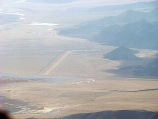
Fukche Advanced Landing Ground is an airfield in the Demchok sector of the union territory of Ladakh, India. It was built shortly before the 1962 Sino-Indian War and was revived in 2008. It is located adjacent to Koyul, 34 km northwest of Demchok.
Chushul is a village in the Leh district of Ladakh, India. It is located in the Durbuk tehsil, in the area known as "Chushul Valley", south of the Pangong Lake and west of the Spanggur Lake. The Line of Actual Control with China runs about 5 miles east of Chushul, across the Chushul Valley. Famous as site for historical battle grounds.
Maryul also called mar-yul of mnga'-ris, was the western most Tibetan kingdom based in modern-day Ladakh and some parts of Tibet. The kingdom had its capital at Shey.

The Khurnak Fort is a ruined fort on the northern shore of Pangong Lake, which spans eastern Ladakh in India and Rutog County in the Tibet region of China. The area of the Khurnak Fort is disputed by India and China, and has been under Chinese administration since 1958.

Chumathang is a village in Leh District, Ladakh in northern India on the banks of the Indus river. Chumathang village is among the first villages in the Changthang region to have its own power station and government high school which was only possible under the guidance of Mr Gonbo. Famous for its hot spring which attracts many tourists all over the world, even the local people come every year to take the medicinal benefits from the hot spring. There is an old monastery or gonpa which is located near the road which is about more than 400 years old and is among the oldest monasteries of Ladakh.
Demchok , previously called New Demchok, and called Parigas by the Chinese, is a village and military encampment in the Indian-administered Demchok sector that is disputed between India and China. It is administered as part of the Nyoma tehsil in the Leh district of Ladakh by India, and claimed by China as part of the Tibet Autonomous Region.
Tangtse or Drangtse (Tibetan: བྲང་རྩེ, Wylie: brang rtse, THL: drang tsé) is a village in the Leh district of Ladakh, India. It is located in the Durbuk tehsil. Traditionally, it was regarded as the border between the Nubra region to the north and the Pangong region to the south. It was a key halting place on the trade route between Turkestan and Tibet. It was also a site of wars between Ladakh and Tibet.
Durbuk or Darbuk, is a village and the headquarters of the eponymous subdivision and block in the Leh district of Ladakh, India. It is located in the Durbuk tehsil, and falls between Chang La mountain pass and Tangste village on the way to Pangong Tso Lake.
Koyul is a village in the Leh district of Ladakh, India. It is located in the Nyoma tehsil, on the banks of the Koyul Lungpa river just before it joins the Indus River.
The Charding Nullah, traditionally known as the Lhari stream and called Demchok River by China, is a small river that originates near the Charding La pass that is also on the border between the two countries and flows northeast to join the Indus River near a peak called "Demchok Karpo" or "Lhari Karpo". There are villages on both sides of the mouth of the river called by the same name "Demchok", which is presumed to have been a single village originally, and has gotten split into two due to geopolitcal reasons. The river serves as the de facto border between China and India in the southern part of the Demchok sector.
The Demchok sector is a disputed area named after the villages of Demchok in Ladakh and Demchok in Tibet, situated near the confluence of the Charding Nullah and Indus River. It is a part of the greater Sino-Indian border dispute between China and India. Both China and India claim the disputed region, with a Line of Actual Control between the two nations situated along the Charding Nullah.

Demchok, was described by a British boundary commission in 1847 as a village lying on the border between the Kingdom of Ladakh and the Tibet. It was a "hamlet of half a dozen huts and tents", divided into two parts by a rivulet which formed the boundary between the two states. The rivulet, a tributary of the Indus River variously called the Demchok River, Charding Nullah, or the Lhari stream, was set as the boundary between Ladakh and Tibet in the 1684 Treaty of Tingmosgang. By 1904–05, the Tibetan side of the hamlet was said to have had 8 to 9 huts of zamindars (landholders), while the Ladakhi side had two. The area of the former Demchok now straddles the Line of Actual Control, the effective border of the People's Republic of China's Tibet Autonomous Region and the Republic of India's Ladakh Union Territory.

Skakjung or Kokzhung is 45–kilometer long pasture land along the right bank of Indus River valley in Southern Ladakh. It is traditionally used by nomads of nearby villages such as Chushul and Nyoma as well as Rupshu. The Skakung pasture land can be used year-round because it rarely snows in the Indus Valley.
Dumchele or Dhumtsele (Chinese: 都木契列; pinyin: Dōu mù qì liè, Tibetan: སྡུམ་མཚེས་ལེ་, Wylie: sdum mtshes le, THL: dum tsé lé) is a village and a grazing area in Skakjung pasture near the Line of Actual Control between Ladakh and Tibet, administered by China since October 1962 but claimed by India. The locale is in the disputed Demchok sector, about 50 kilometers northwest from Demchok and 50 kilometers southeast of Chushul. It lies on a historic trade route between Ladakh and Rutog, with an erstwhile border pass at Chang La or Shingong La to the southeast of Dumchele.