An aquifer is an underground layer of water-bearing material, consisting of permeable or fractured rock, or of unconsolidated materials. Aquifers vary greatly in their characteristics. The study of water flow in aquifers and the characterization of aquifers is called hydrogeology. Related terms include aquitard, which is a bed of low permeability along an aquifer, and aquiclude, which is a solid, impermeable area underlying or overlying an aquifer, the pressure of which could lead to the formation of a confined aquifer. The classification of aquifers is as follows: Saturated versus unsaturated; aquifers versus aquitards; confined versus unconfined; isotropic versus anisotropic; porous, karst, or fractured; transboundary aquifer.

Soil mechanics is a branch of soil physics and applied mechanics that describes the behavior of soils. It differs from fluid mechanics and solid mechanics in the sense that soils consist of a heterogeneous mixture of fluids and particles but soil may also contain organic solids and other matter. Along with rock mechanics, soil mechanics provides the theoretical basis for analysis in geotechnical engineering, a subdiscipline of civil engineering, and engineering geology, a subdiscipline of geology. Soil mechanics is used to analyze the deformations of and flow of fluids within natural and man-made structures that are supported on or made of soil, or structures that are buried in soils. Example applications are building and bridge foundations, retaining walls, dams, and buried pipeline systems. Principles of soil mechanics are also used in related disciplines such as geophysical engineering, coastal engineering, agricultural engineering, hydrology and soil physics.

Frost heaving is an upwards swelling of soil during freezing conditions caused by an increasing presence of ice as it grows towards the surface, upwards from the depth in the soil where freezing temperatures have penetrated into the soil. Ice growth requires a water supply that delivers water to the freezing front via capillary action in certain soils. The weight of overlying soil restrains vertical growth of the ice and can promote the formation of lens-shaped areas of ice within the soil. Yet the force of one or more growing ice lenses is sufficient to lift a layer of soil, as much as 1 foot or more. The soil through which water passes to feed the formation of ice lenses must be sufficiently porous to allow capillary action, yet not so porous as to break capillary continuity. Such soil is referred to as "frost susceptible". The growth of ice lenses continually consumes the rising water at the freezing front. Differential frost heaving can crack road surfaces—contributing to springtime pothole formation—and damage building foundations. Frost heaves may occur in mechanically refrigerated cold-storage buildings and ice rinks.
Soil moisture is the water content of the soil. It can be expressed in terms of volume or weight. Soil moisture measurement can be based on in situ probes or remote sensing methods.
In science and engineering, hydraulic conductivity, is a property of porous materials, soils and rocks, that describes the ease with which a fluid can move through the pore space, or fracture network. It depends on the intrinsic permeability of the material, the degree of saturation, and on the density and viscosity of the fluid. Saturated hydraulic conductivity, Ksat, describes water movement through saturated media. By definition, hydraulic conductivity is the ratio of volume flux to hydraulic gradient yielding a quantitative measure of a saturated soil's ability to transmit water when subjected to a hydraulic gradient.

Water content or moisture content is the quantity of water contained in a material, such as soil, rock, ceramics, crops, or wood. Water content is used in a wide range of scientific and technical areas, and is expressed as a ratio, which can range from 0 to the value of the materials' porosity at saturation. It can be given on a volumetric or mass (gravimetric) basis.
In materials science, bulk density, also called apparent density, is a material property defined as the mass of the many particles of the material divided by the bulk volume. Bulk volume is defined as the total volume the particles occupy, including particle's own volume, inter-particle void volume, and the particles' internal pore volume.

The capillary fringe is the subsurface layer in which groundwater seeps up from a water table by capillary action to fill pores. Pores at the base of the capillary fringe are filled with water due to tension saturation. This saturated portion of the capillary fringe is less than the total capillary rise because of the presence of a mix in pore size. If the pore size is small and relatively uniform, it is possible that soils can be completely saturated with water for several feet above the water table. Alternately, when the pore size is large, the saturated portion will extend only a few inches above the water table. Capillary action supports a vadose zone above the saturated base, within which water content decreases with distance above the water table. In soils with a wide range in pore size, the unsaturated zone can be several times thicker than the saturated zone.
Claypan is a dense, compact, slowly permeable layer in the subsoil. It has a much higher clay content than the overlying material, from which it is separated by a sharply defined boundary. The dense structure restricts root growth and water infiltration. Therefore, a perched water table might form on top of the claypan. In the Canadian classification system, claypan is defined as a clay-enriched illuvial B (Bt) horizon.
Infiltration is the process by which water on the ground surface enters the soil. It is commonly used in both hydrology and soil sciences. The infiltration capacity is defined as the maximum rate of infiltration. It is most often measured in meters per day but can also be measured in other units of distance over time if necessary. The infiltration capacity decreases as the soil moisture content of soils surface layers increases. If the precipitation rate exceeds the infiltration rate, runoff will usually occur unless there is some physical barrier.
The disc permeameter is a field instrument used for measuring water infiltration in the soil, which is characterized by in situ saturated and unsaturated soil hydraulic properties. It is mainly used to provide estimates of the hydraulic conductivity of the soil near saturation.
In soil, macropores are defined as cavities that are larger than 75 μm. Functionally, pores of this size host preferential soil solution flow and rapid transport of solutes and colloids. Macropores increase the hydraulic conductivity of soil, allowing water to infiltrate and drain quickly, and shallow groundwater to move relatively rapidly via lateral flow. In soil, macropores are created by plant roots, soil cracks, soil fauna, and by aggregation of soil particles into peds. Macropores can also be found in soil between larger individual mineral particles such as sand or gravel.
In petrophysics, Archie's law relates the in-situ electrical conductivity (C) of a porous rock to its porosity and fluid saturation of the pores:
Effective porosity is most commonly considered to represent the porosity of a rock or sediment available to contribute to fluid flow through the rock or sediment, or often in terms of "flow to a borehole". Porosity that is not considered "effective porosity" includes water bound to clay particles and isolated "vuggy" porosity. The effective porosity is of great importance in considering the suitability of rocks or sediments as oil or gas reservoirs, or as aquifers.
The void ratio of a mixture of solids and fluids, or of a porous composite material such as concrete, is the ratio of the volume of the voids filled by the fluids to the volume of all the solids. It is a dimensionless quantity in materials science and in soil science, and is closely related to the porosity, the ratio of the volume of voids to the total volume, as follows:
The phreatic zone, saturated zone, or zone of saturation, is the part of an aquifer, below the water table, in which relatively all pores and fractures are saturated with water. The part above the water table is the vadose zone.
Porosity or void fraction is a measure of the void spaces in a material, and is a fraction of the volume of voids over the total volume, between 0 and 1, or as a percentage between 0% and 100%. Strictly speaking, some tests measure the "accessible void", the total amount of void space accessible from the surface.
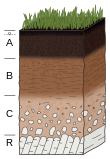
The physical properties of soil, in order of decreasing importance for ecosystem services such as crop production, are texture, structure, bulk density, porosity, consistency, temperature, colour and resistivity. Soil texture is determined by the relative proportion of the three kinds of soil mineral particles, called soil separates: sand, silt, and clay. At the next larger scale, soil structures called peds or more commonly soil aggregates are created from the soil separates when iron oxides, carbonates, clay, silica and humus, coat particles and cause them to adhere into larger, relatively stable secondary structures. Soil bulk density, when determined at standardized moisture conditions, is an estimate of soil compaction. Soil porosity consists of the void part of the soil volume and is occupied by gases or water. Soil consistency is the ability of soil materials to stick together. Soil temperature and colour are self-defining. Resistivity refers to the resistance to conduction of electric currents and affects the rate of corrosion of metal and concrete structures which are buried in soil. These properties vary through the depth of a soil profile, i.e. through soil horizons. Most of these properties determine the aeration of the soil and the ability of water to infiltrate and to be held within the soil.

Fault zone hydrogeology is the study of how brittlely deformed rocks alter fluid flows in different lithological settings, such as clastic, igneous and carbonate rocks. Fluid movements, that can be quantified as permeability, can be facilitated or impeded due to the existence of a fault zone. This is because different mechanisms that deform rocks can alter porosity and permeability within a fault zone. Fluids involved in a fault system generally are groundwater and hydrocarbons.

Pore structure is a common term employed to characterize the porosity, pore size, pore size distribution, and pore morphology of a porous medium. Pores are the openings in the surfaces impermeable porous matrix which gases, liquids, or even foreign microscopic particles can inhabit them. The pore structure and fluid flow in porous media are intimately related.