Risk management is the identification, evaluation, and prioritization of risks followed by coordinated and economical application of resources to minimize, monitor, and control the probability or impact of unfortunate events or to maximize the realization of opportunities.

A flood is an overflow of water that submerges land that is usually dry. In the sense of "flowing water", the word may also be applied to the inflow of the tide. Floods are an area of study of the discipline hydrology and are of significant concern in agriculture, civil engineering and public health. Human changes to the environment often increase the intensity and frequency of flooding, for example land use changes such as deforestation and removal of wetlands, changes in waterway course or flood controls such as with levees, and larger environmental issues such as climate change and sea level rise. In particular climate change's increased rainfall and extreme weather events increases the severity of other causes for flooding, resulting in more intense floods and increased flood risk.
Chronic toxicity, the development of adverse effects as a result of long term exposure to a contaminant or other stressor, is an important aspect of aquatic toxicology. Adverse effects associated with Chronic toxicity can be directly lethal but are more commonly sublethal, including changes in growth, reproduction, or behavior. Chronic toxicity is in contrast to acute toxicity, which occurs over a shorter period of time to higher concentrations. Various toxicity tests can be performed to assess the Chronic toxicity of different contaminants, and usually last at least 10% of an organism's lifespan. Results of aquatic Chronic toxicity tests can be used to determine water quality guidelines and regulations for protection of aquatic organisms.
A biocide is defined in the European legislation as a chemical substance or microorganism intended to destroy, deter, render harmless, or exert a controlling effect on any harmful organism. The US Environmental Protection Agency (EPA) uses a slightly different definition for biocides as "a diverse group of poisonous substances including preservatives, insecticides, disinfectants, and pesticides used for the control of organisms that are harmful to human or animal health or that cause damage to natural or manufactured products". When compared, the two definitions roughly imply the same, although the US EPA definition includes plant protection products and some veterinary medicines.

Environmental remediation is the cleanup of hazardous substances dealing with the removal, treatment and containment of pollution or contaminants from environmental media such as soil, groundwater, sediment. Remediation may be required by regulations before development of land revitalization projects. Developers who agree to voluntary cleanup may be offered incentives under state or municipal programs like New York State's Brownfield Cleanup Program. If remediation is done by removal the waste materials are simply transported off-site for disposal at another location. The waste material can also be contained by physical barriers like slurry walls. The use of slurry walls is well-established in the construction industry. The application of (low) pressure grouting, used to mitigate soil liquefaction risks in San Francisco and other earthquake zones, has achieved mixed results in field tests to create barriers, and site-specific results depend upon many variable conditions that can greatly impact outcomes.

Land development is the alteration of landscape in any number of ways such as:
A hazard analysis is used as the first step in a process used to assess risk. The result of a hazard analysis is the identification of different types of hazards. A hazard is a potential condition and exists or not. It may, in single existence or in combination with other hazards and conditions, become an actual Functional Failure or Accident (Mishap). The way this exactly happens in one particular sequence is called a scenario. This scenario has a probability of occurrence. Often a system has many potential failure scenarios. It also is assigned a classification, based on the worst case severity of the end condition. Risk is the combination of probability and severity. Preliminary risk levels can be provided in the hazard analysis. The validation, more precise prediction (verification) and acceptance of risk is determined in the risk assessment (analysis). The main goal of both is to provide the best selection of means of controlling or eliminating the risk. The term is used in several engineering specialties, including avionics, food safety, occupational safety and health, process safety, reliability engineering.
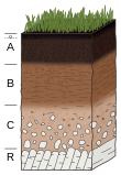
Soil contamination, soil pollution, or land pollution as a part of land degradation is caused by the presence of xenobiotic (human-made) chemicals or other alteration in the natural soil environment. It is typically caused by industrial activity, agricultural chemicals or improper disposal of waste. The most common chemicals involved are petroleum hydrocarbons, polynuclear aromatic hydrocarbons, solvents, pesticides, lead, and other heavy metals. Contamination is correlated with the degree of industrialization and intensity of chemical substance. The concern over soil contamination stems primarily from health risks, from direct contact with the contaminated soil, vapour from the contaminants, or from secondary contamination of water supplies within and underlying the soil. Mapping of contaminated soil sites and the resulting clean ups are time-consuming and expensive tasks, and require expertise in geology, hydrology, chemistry, computer modelling, and GIS in Environmental Contamination, as well as an appreciation of the history of industrial chemistry.
Exposure assessment is a branch of environmental science and occupational hygiene that focuses on the processes that take place at the interface between the environment containing the contaminant of interest and the organism being considered. These are the final steps in the path to release an environmental contaminant, through transport to its effect in a biological system. It tries to measure how much of a contaminant can be absorbed by an exposed target organism, in what form, at what rate and how much of the absorbed amount is actually available to produce a biological effect. Although the same general concepts apply to other organisms, the overwhelming majority of applications of exposure assessment are concerned with human health, making it an important tool in public health.
ISO/IEC 27005 "Information technology — Security techniques — Information security risk management" is an international standard published by the International Organization for Standardization (ISO) and the International Electrotechnical Commission (IEC) providing good practice guidance on managing risks to information. It is a core part of the ISO/IEC 27000-series of standards, commonly known as ISO27k.
In the study of air pollution, a critical load is defined as "a quantitative estimate of an exposure to one or more pollutants below which significant harmful effects on specified sensitive elements of the environment do not occur according to present knowledge".
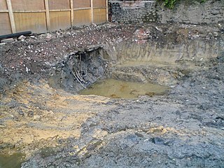
Contaminated land contains substances in or under the land that are definitively or potentially hazardous to health or the environment. These areas often have a long history of industrial production and industrial farming. Many sites may be affected by their former uses such as mining, industry, chemical and oil spills and waste disposal. Areas that were previously industrial areas, called brownfield sites, are higher risk areas.
The Pest Management Regulatory Agency (PMRA) is the Canadian government agency responsible for the regulation of pest control products in Canada under the federal authority of the Pest Control Products Act and Regulations. The agency is a branch that reports to Parliament through Health Canada. The PMRA is responsible for providing access to pest management tools while minimizing the risks to human health and the environment by “using modern evidence-based scientific approaches to pesticide regulation, in an open and transparent manner”. Their main activity areas include: new product evaluation, post market review and compliance and enforcement.
Environmental monitoring describes the processes and activities that need to take place to characterize and monitor the quality of the environment. Environmental monitoring is used in the preparation of environmental impact assessments, as well as in many circumstances in which human activities carry a risk of harmful effects on the natural environment. All monitoring strategies and programs have reasons and justifications which are often designed to establish the current status of an environment or to establish trends in environmental parameters. In all cases, the results of monitoring will be reviewed, analyzed statistically, and published. The design of a monitoring program must therefore have regard to the final use of the data before monitoring starts.
Mathematical exposure modeling is an indirect method of determining exposure, particularly for human exposure to environmental contaminants. It is useful when direct measurement of pollutant concentration is not feasible because direct measurement sometimes requires skilled professionals and complex, expensive laboratory equipment. The ability to make inferences in the absence of direct measurements, makes exposure modeling a powerful tool for predicting exposures by exploring hypothetical situations. It allows researchers to ask "what if" questions about exposure scenarios.

In simple terms, risk is the possibility of something bad happening. Risk involves uncertainty about the effects/implications of an activity with respect to something that humans value, often focusing on negative, undesirable consequences. Many different definitions have been proposed. The international standard definition of risk for common understanding in different applications is "effect of uncertainty on objectives".
Toxic equivalency factor (TEF) expresses the toxicity of dioxins, furans and PCBs in terms of the most toxic form of dioxin, 2,3,7,8-TCDD. The toxicity of the individual congeners may vary by orders of magnitude.
In environmental toxicology, effects range low (ERL) and effects range median (ERM) are measures of toxicity in marine sediment. They are used by public agencies in the United States in formulating guidelines in assessing toxicity hazards, in particular from trace metals or organic contaminants.
Toxicodynamics, termed pharmacodynamics in pharmacology, describes the dynamic interactions of a toxicant with a biological target and its biological effects. A biological target, also known as the site of action, can be binding proteins, ion channels, DNA, or a variety of other receptors. When a toxicant enters an organism, it can interact with these receptors and produce structural or functional alterations. The mechanism of action of the toxicant, as determined by a toxicant’s chemical properties, will determine what receptors are targeted and the overall toxic effect at the cellular level and organismal level.
The predicted no-effect concentration (PNEC) is the concentration of a chemical which marks the limit at which below no adverse effects of exposure in an ecosystem are measured. PNEC values are intended to be conservative and predict the concentration at which a chemical will likely have no toxic effect. They are not intended to predict the upper limit of concentration of a chemical that has a toxic effect. PNEC values are often used in environmental risk assessment as a tool in ecotoxicology. A PNEC for a chemical can be calculated with acute toxicity or chronic toxicity single-species data, Species Sensitivity Distribution (SSD) multi-species data, field data or model ecosystems data. Depending on the type of data used, an assessment factor is used to account for the confidence of the toxicity data being extrapolated to an entire ecosystem.