Transport in Mumbai is achieved by both public, and private transport. As of 2015, 52% of commuters use public transport. Mumbai has the largest organized bus transport network among major Indian cities.

The Mumbai Suburban Railway consists of exclusive inner suburban railway lines augmented by commuter rail on main lines serving outlying suburbs to serve the Mumbai Metropolitan Region. Spread over 390 kilometres (240 mi), the suburban railway operates 2,342 train services and carries more than 7.5 million commuters daily.

Mahim (Marathi: माहिम) is a neighbourhood in Mumbai, Maharashtra, India. The Mahim Junction railway station on the Western Railway and Harbour Railway of the Mumbai Suburban Railway network is the last station of the city, as neighboring Bandra comes in Mumbai Suburb. Mahim is an ethnically and religiously diverse town and has a Hindu temple, church, mosque and Parsi fire-temple existing within a few meters of each other. The town has a large Rich and Upper Middle class Marathi population.
Borivali is a suburb which is located in the north-western End of Mumbai and has a large Marathi population followed by others. Traditionally the tribals and East Indians lived in Borivali.

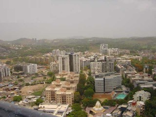
Goregaon ([ɡoːɾeɡaːʋ]) is a suburb of Mumbai city, in the Mumbai Suburban district of India. It has a railway station on the Mumbai suburban railway on the Western Line. An extension of the Harbour Line was completed in 2018 because of which it has regular trains to CSMT on the Harbour line. This is in addition to existing trains to Churchgate on the Western Line. Owing to the rapid urbanization and growing population of metropolitan Mumbai, Goregaon, which was once merely a hilly forest region is now a crowded suburb of Mumbai.

The Western Railway is one of the 19 zones of Indian Railways and is among the busiest railway networks in India, headquartered at Mumbai, Maharashtra. The major railway routes of Indian Railways which come under Western Railways are: Mumbai Central–Ratlam, Mumbai Central–Ahmedabad and Palanpur–Ahmedabad. The railway system is divided into six operating divisions: Ahmedabad, Vadodara, Rajkot, Bhavnagar, Ratlam, and Mumbai WR. Vadodara railway station, being the junction point for the Ahmedabad–Mumbai route and the Mumbai–Ratlam route towards New Delhi, is the busiest junction station in Western Railways and one of the busiest junctions of Indian Railways too, while Ahmedabad Division earns highest revenue followed by Mumbai Division and Vadodara Division. Surat railway station is one of the busiest railway station in Western Railway in non-junction category where more than 180 trains pass per day.
The Harbour line is a branch line of the Mumbai Suburban Railway operated by Central Railway. It was named so because it catered to the eastern neighbourhoods along the city's natural harbour. Its termini are Chhatrapati Shivaji Maharaj Terminus (CSMT), Goregaon and Panvel on the CSMT-Goregaon, CSMT-Panvel and Panvel-Goregaon routes.
The Mumbai Urban Transport Project (MUTP), is a project formulated by the Mumbai Metropolitan Region Development Authority (MMRDA) to bring about improvement in the traffic and transport situation in the Mumbai metropolitan region with the assistance of the World Bank.
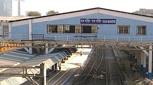
Oshiwara is a neighbourhood in northern Mumbai, India near Lokhandwala Complex. Its name was derived from the Oshiwara River. Located between the western sides of Goregaon and Jogeshwari, it has many industrial estates. A railway station was built at Oshiwara, called Ram Mandir, for the Western Line of Mumbai Suburban Railway, providing service to the extended Andheri and Lokhandwala areas of the western suburbs. Oshiwara is also known for its antique and second-hand furniture market, as well as its food corners.
Bangur Nagar is a residential area in Goregaon West, Mumbai, India. It was developed by the Bangur Group of Kolkata in the mid-1970s.
The Western Railway Elevated Corridor, also known as the Oval Maidan-Virar elevated corridor, was a proposed rapid transit corridor that would have run along the same alignment as the Western Line of the Mumbai Suburban Railway, and link Oval Maidan with Virar.

Churchgate is the southern terminus on the Western Line of the Mumbai Suburban Railway. It is located in Churchgate in South Mumbai, Maharashtra.
The Western line of the Mumbai Suburban Railway is a public transit system serving Mumbai Metropolitan Region, Maharashtra. It consists of 37 stations from Dahanu Road to Churchgate railway station. It is operated by Western Railways (WR). The entire line is at grade.

Andheri is a passenger rail station located at Andheri suburb of Mumbai. It serves the Western line and Harbour lines of the Mumbai Suburban Railway. It is also a stop for some express trains and August Kranti Rajdhani Express. The station also inter-connects the Line 1 of the Andheri metro station. Andheri station first came under prominence after the development of Salsette–Trombay Railway services in 1928 by the British Empire of India during the pre-independence period.
Jogeshwari is a railway station in the Jogeshwari suburb of Mumbai city. The station lies on the Western line of the Mumbai Suburban Railway network between Andheri and Ram Mandir railway stations. On March 29, 2018, Harbour line was extended from Mumbai CSMT to Goregaon.

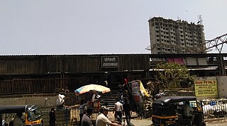
Goregaon is a railway station on the Western line and Harbour line of the Mumbai Suburban Railway network. It serves the suburb of Goregaon. As a general rule, Virar-bound fast trains skip Goregaon, while Borivali-bound fast trains halt here but being in middle between Andheri and Borivali ; it hosts as an important halt for termination and origination of Churchgate and Mumbai CSMT/ Panvel bound services with access to various areas of Dindoshi, Oshiwara, Film City and outlining areas from Malad and Jogeshwari.

Mira Road is a passenger railway station located at Mira Road, a suburb in the Western Suburbs of Mumbai. It is situated between Borivali and Bhayandar stations on the Western line, of Mumbai Suburban Railway. The route of the station is located between the salt pan towards the western zone of the suburb leading towards Bhayandar.

Ayodhya Junction railway station, officially named as Ayodhya Dham Junction railway station, is a railway station in the city of Ayodhya in the state of Uttar Pradesh, India. It is located at Dharmakata, 1.5 km (0.93 mi) south-west from the city centre and 1.2 km (0.75 mi) south-east from Ram Mandir. It is one of two railway junction stations in the city; the other one is Faizabad Junction. The station falls under the Northern Railway zone of the Indian Railways. The station's code is "AY".
The Western Suburbs is the western precinct of the city of Mumbai, India. The Western Suburbs consist of Andheri, Bandra, Bhayander, Borivali, Dahisar, Goregaon, Jogeshwari, Juhu, Kandivali, Khar, Malad, Mira Road, Santacruz and Vile Parle. Geographically, the Western Suburbs lie at the western part of Salsette Island, is a continuous urban sprawl spanning the areas from Bandra to Bhayander, which is separated by the Vasai Creek from Vasai-Virar city and Mithi River from Mumbai city district.