Agua Dulce people

Last updated
Utina
Lemoy012.jpg
One of Theodor de Bry's engravings, supposedly based on drawings by Jacques LeMoyne, depicting Chief Utina consulting his "sorcerer" before battle
Total population
Extinct as tribe
Regions with significant populations
North Florida along the middle St. Johns River
Languages
Timucua language, Agua Fresca dialect
Religion
Native
Related ethnic groups
Timucua

The Agua Dulce or Agua Fresca (Freshwater) were a Timucua people of northeastern Florida. They lived in the St. Johns River watershed north of Lake George, and spoke a dialect of the Timucua language also known as Agua Dulce.

Contents

In the 1560s, Agua Dulce villages were organized into the chiefdom of Utina, one of the region's most powerful and prominent forces in the early days of European colonization in Florida. Utina had dealings with the French colony of Fort Caroline, and later allied with the Spanish of St. Augustine, who established several missions in its territory. However, the chiefdom declined significantly in the last decades of the 16th century, and the confederacy fragmented into at least three chiefdoms.

The main body of the tribe withdrew south along the St. Johns River, and were known as the Agua Dulce to the Spanish. This chiefdom was largely abandoned by 1680. Additionally, a group of Christianized Agua Dulce migrated east towards St. Augustine, and became known as the Tocoy, but this small chiefdom disappeared by 1616. The Acuera, who spoke a different dialect but appear to have been part of the Utina confederacy in the days of French settlement, also broke away and established their own chiefdom. The Acuera proved more sustainable than the Agua Dulce and Tocoy chiefdoms, but had collapsed by 1680.

Name

Agua Dulce or Agua Fresca (both meaning "Freshwater") was a Spanish term for Timucua living along the freshwater lower St. Johns River, as opposed to the Mocama or "Salt Water" who lived along the coast. [1] The Utina chiefdom of the late 16th century is so called after its paramount chief at the time of contact with the Europeans, Olata Ouae Utina; other spellings of the name include "Outina". The name "Utina" does not appear to be a designation specific to this group; uti-na means "my land" in Timucuan. [2] The Saturiwa, another Timucua chiefdom who were enemies of the Utina, called them "Thimogona" or "Tymangoua", which is possibly the origin of the name "Timucua". [2] The French followed the Saturiwa in this use, but later, the Spanish used the word "Timucua" for a much wider area of northern Florida, which they incorporated into their mission system as the Timucua Province. [2]

In the 17th century the Spanish thus came to know the principal tribe in the Timucua Province, who lived to the north of the former Utina chiefdom, as the Timucua. At this time, the descendants of Chief Utina's people were known instead as the Agua Dulce. [3] In the 20th century, after the name "Timucua" had come to be applied to all speakers of the Timucua language, scholars began using "Utina" as a generic term for the group the Spanish had known as the Timucua. However, this has caused confusion between the 16th-century Utina chiefdom and the "Timucua proper", who were never known as Utina by their contemporaries. Scholars Jerald Milanich and Ken Johnson have suggested classing the two groups as eastern Utina and Northern Utina, respectively. [3] According to scholar John H. Hann, the village that served as the center of the chiefdom was later referred to as Nyaautina by historical sources. [4]

Area

A map of the Agua Dulce peoples AguaFresca-People-Map.png
A map of the Agua Dulce peoples

The Agua Dulce lived along the St. Johns River, from north of present-day Palatka to Lake George. They occupied an area to the west in what are now Clay and Putnam Counties, and on freshwater lagoons and inlets along the Atlantic coast. [5] [6]

The French record that in the 1560s Chief Utina had more than forty other village chiefs as his vassals. His main village was located about seventeen miles to the west of the St. Johns, perhaps near George's Lake (distinct from Lake George) in northwestern Putnam County. The place name Etoniah, derived from Utina, still survives through this area, for instance in Etoniah Creek. [7] However, as this area is well north of the distribution of late prehistoric archaeological sites, which are concentrated between about Palatka and Lake George, it is possible that the Utina had gained control of this northern stretch relatively recently. [8] Other villages subject to Chief Utina were Coya and Molona on the St. Johns; moving upriver to the south were the villages of Patica, Chilili, and Enacape. [9] French sources record that the Acuera, another Timucua tribe on the Oklawaha River farther south and who spoke a different dialect, were also part of the Utina chiefdom, as were groups on the east side of the St. Johns. [9]

To the west of the Utina, in the area around present-day Gainesville, were the Potano, another Timucua group who were enemies of the Utina. [10] Down the St. Johns to the north, in an area stretching roughly from what is now downtown Jacksonville to the mouth of the river, were another enemy chiefdom, the Saturiwa. The stretch of river between about Palatka and Jacksonville was relatively less populated, and may have served as a boundary between the Utina and the Saturiwa. [10] Up the river south of Lake George were the Mayaca, who were culturally similar to the Utina but did not speak the Timucua language and were more closely aligned with the Ais of the Atlantic coast. [11]

Early history and European contact

Chief Utina defeats the Potano with the aid of French forces. This engraving supposedly based on an original painting by Jacques le Moyne is unlikely to depict Native American warfare accurately Outina, aided by the French, overcomes his enemy, Potanou.tiff
Chief Utina defeats the Potano with the aid of French forces. This engraving supposedly based on an original painting by Jacques le Moyne is unlikely to depict Native American warfare accurately

The area had been populated for thousands of years. An archaeological culture known as the St. Johns culture emerged around 500 BC, and was still extant at the time of contact with the Europeans. At some point after the 8th century, Mississippian culture models, common throughout what is now the eastern United States, began to proliferate in Florida, and Mississippian-style chiefdoms emerged. [12] Archaeologists have uncovered two clusters of St. Johns-related sites along the river dating to the late prehistoric period. These correspond closely with the Utina and Saturiwa chiefdoms described by the Europeans, suggesting they were long established. [13] The Agua Dulce built burial mounds and left large shell middens, among the largest found in the United States. [14] They grew crops, but were not as dependent on agriculture as were tribes to the north; those living on the lagoons along the coast may not have practiced agriculture at all. [14]

The Acuera, one of the peoples noted by the French as part of Chief Utina's alliance, encountered the conquistador Hernando de Soto's expedition in 1539. De Soto stole corn from the Acuera while camped out in the nearby town of Ocale. [8] However, extensive contact with Europeans did not occur until 1564, when the French Huguenots from the recently established Fort Caroline in present-day Jacksonville first visited the area. The French noted that at this time all the villages along the middle St. Johns, as well as some farther into the interior such as those of the Acuera, were part of a chiefdom ruled by a young leader named Utina. Though only 25 years old, Utina had sovereignty over forty other chiefs and their villages, and was one of the most powerful figures in northern Florida. [9] [15] The exact nature of Utina's chiefdom is unclear. He may have been the paramount head of an integrated chiefdom, or he may have been simply the leading chief in a confederacy of smaller chiefdoms. In any case he was treated as a powerful leader by the French and Spanish. [11]

At this time the Utina appear to have been at war with two other powerful chiefdoms: the Saturiwa to the north and the Potano to the west. The French had forged a treaty of friendship with Chief Saturiwa, in whose territory their fort stood, but governor René Goulaine de Laudonnière still sought the favor of the powerful Utina. He sent an expedition that made contact with the Utina and aided them in an assault on the Potano. Later he refused to aid Saturiwa in an offensive against the Utina, straining relations with him. However, when French stores were running low in the spring of 1565, Utina exploited their situation to coerce Laudonnière into sending more military aid. When they realized that Utina was manipulating them, the desperate French kidnapped the chief in order to ransom him for supplies. This led to battle between the French and the Utina, which had grave effects for both sides. The French were unable to secure much food, and eventually released Utina. [16]

Later that year, the Spanish, recently established in St. Augustine, sieged Fort Caroline and ejected the French from Florida. The Utina quickly allied with the Spanish. In 1567, the Spanish assisted them against a coalition of the Saturiwa, Potano, and Mayaca, joining them in driving the Potano from their main village. However, over the next two decades the Spanish paid little attention to the Utina. [17] Concurrently the once-powerful confederacy declined significantly and fragmented. [18]

Fragmentation

By the time Franciscan missionary efforts began in the area in the 1590s, there had been a significant decrease in both population and in the number of remaining villages in the Agua Dulce area. Moreover, there appear to have been at least three smaller, independent chiefdoms in what had formerly been Utina territory. The details of the decline are unclear, but the more devastating warfare and diseases introduced by the Europeans probably contributed. [18] The core part of the chiefdom remained inhabited, but the declining population appears to have withdrawn south, with the administrative center shifting to the village of Antonico. The Spanish referred to the inhabitants as the Agua Dulce or Agua Fresca, the Freshwater tribe. [18] Northern villages that had not been abandoned were at that time under the authority of the Christian chiefs of Tocoy. The Tocoy chiefdom established a new town to the east, closer to St. Augustine. [19] Additionally, the Acuera, who part of Chief Utina's confederacy in the 1560s, had become an independent chiefdom. [20]

Agua Dulce chiefdom

The Mount Royal site, probably the town of Enacape MountRoyalOutside.jpg
The Mount Royal site, probably the town of Enacape

The Agua Dulce chiefdom inhabited a territory comprising the former center of the Utina chiefdom in what the Spanish called the Agua Dulce province. By 1595 Chief Utina appears to have been succeeded, at some remove or another, by the Christian chief Antonico, who ruled from a village also known as Antonico southeast of the old main village. Its precise location is unclear, but it certainly would have been part of Utina's confederacy if it existed at that time. Most of the northern villages, including the main town, were evidently abandoned, and the number of villages in the chiefdom were reduced to about six, situated between the Palatka area and Lake George. [18] In 1595, Franciscan friars founded a mission in Antonico village, incorporating Agua Dulce province into the mission system. [9] [21] The chiefdom maintained good relations with the Spanish, although it had no permanent friar from 1597 to 1605. [22] In this period, the Agua Dulce population had shrunk drastically to about 200-225 people. [23]

By 1616, the administrative center of the Agua Dulce had shifted south again, to Enacape (perhaps the Mount Royal site near Lake George). Anthropologist John E. Worth suggests the transfer occurred as part of the succession to Chief Antonico, who had apparently died. Antonico was succeeded by his nephew, Juan de Contreras, whose mother was evidently the chief of Enacape. Juan may have moved the administrative center due to his filial connections to the town. [24] The Spanish established a mission there, San Antonio de Enacape. [9] [25]

By the 1640s, the Agua Dulce Province had declined so much that it was merged with two others, Acuera and the remote Mayaca, to form the Ibiniuti Province. This change may have been dictated by the Spanish administration, but the fact that it had a Timucua name suggests the native political structure may also have changed based on the severe population changes. [26] In this period the distant province became a haven for Timucua fleeing the colonial labor system along the Spanish royal road, the Camino Royal, as well as Chisca people invited to the area by the Spanish. [27] In 1656, the Franciscans withdrew their friars from the entire province and established the mission town of Salamototo, which drew Indians from across the upper St. Johns. Though some Agua Dulce may have remained in their homeland, others evidently relocated to Salamototo. [28] San Antonio de Enacape was occupied by Yamassee refugees in the 1680 mission lists. [29] As with other Timucua peoples, remaining Agua Dulce probably mixed with other peoples and lost their independent identity. [30]

Tocoy chiefdom

The village of Tocoy on the St. Johns River became the center of an independent chiefdom in the later 16th century. Tocoy was located due west of St. Augustine and east of the old Utina village. It was thus presumably part of Utina's chiefdom in the 1560s, though at the northernmost bounds. [31] Shortly after the foundation of St. Augustine, the chief of Tocoy, Pedro Márquez, moved to a new village closer to the Spanish settlement, known as San Sebastián. Consequently, Pedro and his successor were often known as Chief of Tocoy and San Sebastián. [31] Pedro was one of the first chiefs to submit to Spanish authority, and converted to Christianity even before missionary efforts began. His son and successor Gaspar Márquez later noted that his father and mother had been "some of the first Christians baptized in these provinces", and had requested missionaries and built churches in San Sebastián. [31] [32] The relocation to San Sebastián and the alignment with the Spanish evidently elevated the profile of the Chiefs of Tocoy, who had probably been marginal in the Utina chiefdom, and facilitated the break. [31]

The Spanish established missions in both Tocoy and San Sebastián in 1587; these, together with the missions to the Mocama to north, were among the first successful missions established in Spanish Florida. [33] Gaspar Márquez succeeded his father around 1595, and maintained Pedro's good relations with the Spanish. [31] He continued to support the mission effort, and sent a petition to the King of Spain in 1606, but his people were in a state of precipitous decline. [34] In 1606, there were only about 90 people left in the chiefdom. [35]

Neither of Tocoy's missions is mentioned in records after 1608, and Tocoy was abandoned by 1616, leaving the area virtually unpopulated. [34] The area was merged with Agua Dulce Province, and any survivors may have relocated to Mission Nombre de Dios north of St. Augustine. [36] Because of its strategic location as a river crossing on the St. Johns, the Spanish relocated other Timucua to a new mission, San Diego de Helaca, in the former Tocoy area. This too was abandoned by the late 1650s, the remaining population relocated to the new multi-ethnic mission town of Salamototo. [37] The short-lived chiefdom of Tocoy left its mark on the landscape in the name of the San Sebastian River, the small river that flows into the Intracoastal Waterway where the erstwhile village of San Sebastián stood. [38]

Acuera chiefdom

The Acuera, who lived along Ocklawaha River, seem have become independent of the Agua Dulce chiefdom by the start of the 16th century, and founded at least one chiefdom of their own. The French sources attest that they were part of Utina's confederacy in the 1560s, though Worth notes that the level of control Utina exercised over them is arguable. [38] Francisco Pareja noted that the Acuera spoke their own dialect of the Timucua language (Acuera), distinct from the Agua Dulce dialect. [39] The Acuera did not experience demographic decline nearly as quickly as the Agua Dulce or Tocoy chiefdoms, perhaps partially because of their remote location in the Florida interior and their less frequent contact with the Europeans. [38] In the early mission period they may have had a population between 2,500-4,500. [40] As such, Acuera represents one of the simpler, localized chiefdoms that proved sustainable well after more integrated societies such as Utina's confederacy had fallen. [38]

Spanish records from the late 16th century indicate that Acuera village was ruled by a cacica (female chief). The chiefdom may have been relatively unintegrated. Some villages in the Acuera Province were missionized years before the main town, and some village chiefs rendered their obedience to the Spanish before the Cacica of Acuera village had done so. According to Worth, the Tucururu dialect, which Francisco Pareja noted was similar to but distinct from Acuera, may have been spoken in the Acuera Province, perhaps around the village of Tucuru. As such, the villages of the province may have been largely independent and only loosely associated with the main town. Alternately, the missionized villages, all located in the eastern part of the province, may have represented another small chiefdom or chiefdoms situated between Acuera and Agua Dulce. [41]

The Spanish established Mission San Blas de Avino in the town of Avino by 1612, but it was abandoned not long after. [42] By 1640, the population had decreased to the point that Acuera was joined with Agua Dulce and Mayaca into the Ibiniuti province. [26]

By 1655 there were two further missions, Santa Lucia de Acuera in the main village and San Luis de Eloquale in Eloquale. [42] Both of these were abandoned by 1680, and like Agua Dulce, the Acuera Province was merged into the larger Timucua Province. [42] [43] Any survivors may have relocated closer to St. Augustine, perhaps to the Puebla de Timucua, and lost their independent identity. [42]

Notes

  1. Milanich, p. 42, 98–99.
  2. 1 2 3 Milanich, p. 46.
  3. 1 2 Worth, The Timucuan Chiefdoms of Spanish Florida, Vol. 1, p. xxii.
  4. Hann, p. 16
  5. Milanich, p. 46; 51.
  6. Hann, p. 10
  7. Milanich, p. 51.
  8. 1 2 Worth, The Timucuan Chiefdoms of Spanish Florida, Vol. 1, p. 21.
  9. 1 2 3 4 5 Milanich, p. 52.
  10. 1 2 Milanich, p. 53.
  11. 1 2 Worth, The Timucuan Chiefdoms of Spanish Florida, Vol. 1, p. 22.
  12. Worth, The Timucuan Chiefdoms of Spanish Florida, Vol. 1, pp. 19–20.
  13. Worth, The Timucuan Chiefdoms of Spanish Florida, Vol. 1, pp. 20–21.
  14. 1 2 Hann, p. 13
  15. Worth, The Timucuan Chiefdoms of Spanish Florida, Vol. 1, pp. 21–22.
  16. Hann, pp. 38–49.
  17. Hann, pp. 63–64.
  18. 1 2 3 4 Worth, The Timucuan Chiefdoms of Spanish Florida, Vol. 1, p. 23.
  19. Worth, The Timucuan Chiefdoms of Spanish Florida, Vol. 1, p. 23–24.
  20. Worth, The Timucuan Chiefdoms of Spanish Florida, Vol. 1, p. 24.
  21. Worth, The Timucuan Chiefdoms of Spanish Florida, Vol. 1, p. 48.
  22. Worth, The Timucuan Chiefdoms of Spanish Florida, Vol. 1, pp. 54, 58–59.
  23. Worth, The Timucuan Chiefdoms of Spanish Florida, Vol. 2, p. 3.
  24. Worth, The Timucuan Chiefdoms of Spanish Florida, Vol. 1, pp. 62–63.
  25. Worth, The Timucuan Chiefdoms of Spanish Florida, Vol. 1, p. 63.
  26. 1 2 Worth, The Timucuan Chiefdoms of Spanish Florida, Vol. 2, p. 32.
  27. Worth, The Timucuan Chiefdoms of Spanish Florida, Vol. 2, pp. 32–35.
  28. Worth, The Timucuan Chiefdoms of Spanish Florida, Vol. 2, p. 100.
  29. Swanton, pp. 130–131.
  30. Swanton, p. 151.
  31. 1 2 3 4 5 Worth, The Timucuan Chiefdoms of Spanish Florida, Vol. 1, pp. 23–25.
  32. Worth, The Timucuan Chiefdoms of Spanish Florida, Vol. 1, p. 46.
  33. Worth, The Timucuan Chiefdoms of Spanish Florida, Vol. 1, p. 47.
  34. 1 2 Worth, The Timucuan Chiefdoms of Spanish Florida, Vol. 1, pp. 68–69.
  35. Worth, The Timucuan Chiefdoms of Spanish Florida, Vol. 2, p. 7.
  36. Worth, The Timucuan Chiefdoms of Spanish Florida, Vol. 1, p. 62.
  37. Worth, The Timucuan Chiefdoms of Spanish Florida, Vol. 2, pp. 32–33, 100.
  38. 1 2 3 4 Worth, The Timucuan Chiefdoms of Spanish Florida, Vol. 1, p. 25.
  39. Milanich, p. 43.
  40. Worth, The Timucuan Chiefdoms of Spanish Florida, Vol. , pp. 7–8.
  41. Worth, The Timucuan Chiefdoms of Spanish Florida, Vol. 1, pp. 65–66.
  42. 1 2 3 4 Swanton, p. 120.
  43. Milanich, p. 99.

Related Research Articles

<span class="mw-page-title-main">San Juan del Puerto, Florida</span> Spanish mission in Florida

San Juan del Puerto was a Spanish Franciscan mission founded before 1587 on Fort George Island, near the mouth of the St. Johns River in what is now Jacksonville, Florida. It was founded to serve the Saturiwa, a Timucua tribe who lived around the mouth of the St. Johns. It was organized by separating them into nine smaller villages. It has an important place in the study of the Timucua, as the place where Francisco Pareja undertook his work on the Timucua language.

<span class="mw-page-title-main">Timucua language</span> Extinct language in Florida and Georgia, USA

Timucua is a language isolate formerly spoken in northern and central Florida and southern Georgia by the Timucua peoples. Timucua was the primary language used in the area at the time of Spanish colonization in Florida. Differences among the nine or ten Timucua dialects were slight, and appeared to serve mostly to delineate band or tribal boundaries. Some linguists suggest that the Tawasa of what is now northern Alabama may have spoken Timucua, but this is disputed.

<span class="mw-page-title-main">Potano</span> Native American chiefdom in Florida, US

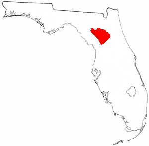
The Potano tribe lived in north-central Florida at the time of first European contact. Their territory included what is now Alachua County, the northern half of Marion County and the western part of Putnam County. This territory corresponds to that of the Alachua culture, which lasted from about 700 until 1700. The Potano were among the many tribes of the Timucua people, and spoke a dialect of the Timucua language.

Utinahica was a town that was the site of a Spanish mission, Santa Isabel de Utinahica. It may have been the chief town of a Timucua tribe and chiefdom in the 17th century, but Hann says there is not enough known about it to be sure. The name means "lord's village". Utinahica, was called a "province" in one Spanish report. It was 30 leagues east of Arapaha, and 50 leagues northeast of the town of Tarihica in the Northern Utina Province. It was at or near where the Oconee and Ocmulgee rivers join to form the Altamaha River. The people of Utinahica apparently practiced a regional variant of the Lamar regional culture, unusual for a Timucuan-speaking people. Worth identifies the province of Utinahica with archaeological sites, including the Lind Landing site, Coffee Bluff site, and Bloodroot site, that have yielded artifacts of the Square Ground Lamar culture from before the 15th century until the middle of the 17th century. The Square Ground Lamar culture is otherwise associated with sites occupied by speakers of Muskogean languages. Archaeological sites identified with all other known Timucuan-speakers, with the possible exception of Guadalquini, do not have affinities with the Square Ground Lamar culture.

<span class="mw-page-title-main">Mocama</span> Indigenous people of Florida and Georgia, US

The Mocama were a Native American people who lived in the coastal areas of what are now northern Florida and southeastern Georgia. A Timucua group, they spoke the dialect known as Mocama, the best-attested dialect of the Timucua language. Their heartland extended from about the Altamaha River in Georgia to south of the mouth of the St. John's River, covering the Sea Islands and the inland waterways, Intracoastal. and much of present-day Jacksonville. At the time of contact with Europeans, there were two major chiefdoms among the Mocama, the Saturiwa and the Tacatacuru, each of which evidently had authority over multiple villages. The Saturiwa controlled chiefdoms stretching to modern day St. Augustine, but the native peoples of these chiefdoms have been identified by Pareja as speaking Agua Salada, which may have been a distinct dialect.

<span class="mw-page-title-main">Saturiwa (chief)</span>

Saturiwa was chief of the Saturiwa tribe, a Timucua chiefdom centered at the mouth of the St. Johns River in Florida, during the 16th century. His main village, also known as Saturiwa, was located on the south bank of the river near its mouth, and according to French sources he was sovereign over thirty other village chiefs. Chief Saturiwa was a prominent figure in the early days of European settlement in Florida, forging friendly relations with the French Huguenot settlers, who founded Fort Caroline in his territory.

<span class="mw-page-title-main">Spanish missions in Florida</span> Catholic religious outposts

Beginning in the second half of the 16th century, the Kingdom of Spain established a number of missions throughout La Florida in order to convert the Native Americans to Christianity, to facilitate control of the area, and to prevent its colonization by other countries, in particular, England and France. Spanish Florida originally included much of what is now the Southeastern United States, although Spain never exercised long-term effective control over more than the northern part of what is now the State of Florida from present-day St. Augustine to the area around Tallahassee, southeastern Georgia, and some coastal settlements, such as Pensacola, Florida. A few short-lived missions were established in other locations, including Mission Santa Elena in present-day South Carolina, around the Florida peninsula, and in the interior of Georgia and Alabama.

Mayaca was the name used by the Spanish to refer to a Native American tribe in central Florida, to the principal village of that tribe and to the chief of that village in the 1560s. The Mayacas occupied an area in the upper St. Johns River valley just to the south of Lake George. According to Hernando de Escalante Fontaneda, the Mayaca language was related to that of the Ais, a tribe living along the Atlantic coast of Florida to the southeast of the Mayacas. The Mayacas were hunter-fisher-gatherers, and were not known to practice agriculture to any significant extent, unlike their neighbors to the north, the Utina, or Agua Dulce (Freshwater) Timucua. The Mayaca shared a ceramics tradition with the Freshwater Timucua, rather than the Ais.

Santa Fe de Toloca was a Spanish mission that existed near the Santa Fe River in the northwestern part of what is now Alachua County, Florida, United States during the 17th century. It became an important place on the camino real connecting St. Augustine with Apalachee Province, which was centered on the site of present-day Tallahassee, Florida. The site that the Santa Fe de Toloca mission occupied in the first half of the 17th century was partially excavated in the 1980s.

Acuera was the name of both an indigenous town and a province or region in central Florida during the 16th and 17th centuries. The indigenous people of Acuera spoke a dialect of the Timucua language. In 1539 the town first encountered Europeans when it was raided by soldiers of Hernando de Soto's expedition. French colonists also knew this town during their brief tenure (1564–1565) in northern Florida.

<span class="mw-page-title-main">Timucua</span> Native American people

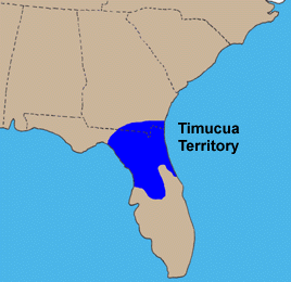
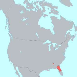
The Timucua were a Native American people who lived in Northeast and North Central Florida and southeast Georgia. They were the largest indigenous group in that area and consisted of about 35 chiefdoms, many leading thousands of people. The various groups of Timucua spoke several dialects of the Timucua language. At the time of European contact, Timucuan speakers occupied about 19,200 square miles (50,000 km2) in the present-day states of Florida and Georgia, with an estimated population of 200,000. Milanich notes that the population density calculated from those figures, 10.4 per square mile (4.0/km2) is close to the population densities calculated by other authors for the Bahamas and for Hispaniola at the time of first European contact. The territory occupied by Timucua speakers stretched from the Altamaha River and Cumberland Island in present-day Georgia as far south as Lake George in central Florida, and from the Atlantic Ocean west to the Aucilla River in the Florida Panhandle, though it reached the Gulf of Mexico at no more than a couple of points.

The indigenous peoples of Florida lived in what is now known as Florida for more than 12,000 years before the time of first contact with Europeans. However, the indigenous Floridians living east of the Apalachicola River had largely died out by the early 18th century. Some Apalachees migrated to Louisiana, where their descendants now live; some were taken to Cuba and Mexico by the Spanish in the 18th century, and a few may have been absorbed into the Seminole and Miccosukee tribes.

<span class="mw-page-title-main">Mocoso</span> 16th-century chiefdom in Florida

Mocoso was the name of a 16th-century chiefdom located on the east side of Tampa Bay, Florida near the mouth of the Alafia River, of its chief town and of its chief. Mocoso was also the name of a 17th-century village in the province of Acuera, a branch of the Timucua. The people of both villages are believed to have been speakers of the Timucua language.

<span class="mw-page-title-main">Saturiwa</span> Timucua chiefdom in Spanish Florida

The Saturiwa were a Timucua chiefdom centered on the mouth of the St. Johns River in what is now Jacksonville, Florida. They were the largest and best attested chiefdom of the Timucua subgroup known as the Mocama, who spoke the Mocama dialect of Timucuan and lived in the coastal areas of present-day northern Florida and southeastern Georgia. They were a prominent political force in the early days of European settlement in Florida, forging friendly relations with the French Huguenot settlers at Fort Caroline in 1564 and later becoming heavily involved in the Spanish mission system.

Tacatacuru was a Timucua chiefdom located on Cumberland Island in what is now the U.S. state of Georgia in the 16th and 17th centuries. It was one of two chiefdoms of the Timucua subgroup known as the Mocama, who spoke the Mocama dialect of Timucuan and lived in the coastal areas of southeastern Georgia and northern Florida.

<span class="mw-page-title-main">Northern Utina</span> Extinct Native American people in Florida

The Northern Utina, also known as the Timucua or simply Utina, were a Timucua people of northern Florida. They lived north of the Santa Fe River and east of the Suwannee River, and spoke a dialect of the Timucua language known as "Timucua proper". They appear to have been closely associated with the Yustaga people, who lived on the other side of the Suwannee. The Northern Utina represented one of the most powerful tribal units in the region in the 16th and 17th centuries, and may have been organized as a loose chiefdom or confederation of smaller chiefdoms. The Fig Springs archaeological site may be the remains of their principal village, Ayacuto, and the later Spanish mission of San Martín de Timucua.

The Yustaga were a Timucua people of what is now northwestern Florida during the 16th and 17th centuries. The westernmost Timucua group, they lived between the Aucilla and Suwannee Rivers in the Florida Panhandle, just east of the Apalachee people. A dominant force in regional tribal politics, they may have been organized as a loose regional chiefdom consisting of up to eight smaller local chiefdoms.

Ocale was the name of a town in Florida visited by the Hernando de Soto expedition, and of a putative chiefdom of the Timucua people. The town was probably close to the Withlacoochee River at the time of de Soto's visit, and may have later been moved to the Oklawaha River.

San Buenaventura de Potano was a Spanish mission near Orange Lake in southern Alachua County or northern Marion County, Florida, located on the site where the town of Potano had been located when it was visited by Hernando de Soto in 1539. The Richardson/UF Village Site (8AL100), in southern Alachua County, has been proposed as the location of the town and mission.

Arapaha was a Timucua town on the Alapaha River in the 17th century. The name was also sometimes used to designate a province or sub-province in Spanish Florida.

References