Aberdeen is a city in and the county seat of Brown County, South Dakota, United States, located approximately 125 miles (201 km) northeast of Pierre. The city population was 28,495 at the 2020 census, making it the third most populous city in the state after Sioux Falls and Rapid City. Aberdeen is the principal city of the Aberdeen Micropolitan Statistical Area, which includes all of Brown and Edmunds counties and has a population of 42,287 in 2020. Aberdeen is considered a college town, being the home of both Northern State University and Presentation College.
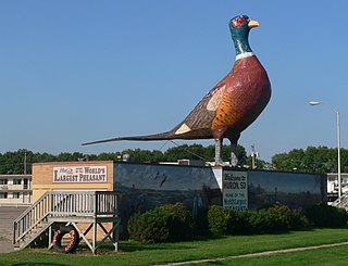
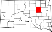
Huron is a city in Beadle County, South Dakota, United States. It is the county seat of Beadle County. The population was 14,263 at the 2020 census, and it is the 8th most populous city in South Dakota.

Dallas is a town in Gregory County, South Dakota, United States. The population was 89 at the 2020 census.

Gregory is a city in western Gregory County, South Dakota, United States. The population was 1,221 at the 2020 census.

Northville is a town in Spink County, South Dakota, United States. The population was 139 at the 2020 census.

Redfield is a city in and the county seat of Spink County, South Dakota, United States. The population was 2,214 at the 2020 census. The city was named for J. B. Redfield, a railroad official.
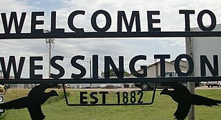
Wessington is a city on the border between Beadle and Hand counties in South Dakota, United States. The population was 197 at the 2020 census.
The Grand River is a tributary of the Missouri River in South Dakota in the United States. The length of the combined branch is 110 mi (177 km). With its longest fork, its length is approximately 200 mi (320 km).
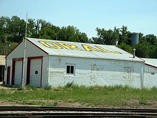
Oral is an unincorporated community and census-designated place (CDP) in Fall River County, South Dakota, United States. The population was 66 at the 2020 census.
Saint Onge is an unincorporated community and census-designated place (CDP) in Lawrence County, South Dakota, United States. As of the 2020 census, the population was 170.
Smithwick is an unincorporated community and census-designated place (CDP) in Fall River County, South Dakota, United States. The population was 39 at the 2020 census. Smithwick has been assigned the ZIP code of 57782.
The Touchet River is a 55-mile (89 km) tributary of the Walla Walla River in southeastern Washington in the United States. The Touchet River drains an area of about 740 square miles (1,900 km2) in Columbia County and Walla Walla County.

Minnesela is a ghost town and was the first settlement in and county seat of Butte County, South Dakota, United States. Minnesela was founded in 1882 and was located three miles southeast of present-day Belle Fourche. The railroad's decision to bypass Minnesela and to continue on to Belle Fourche in 1890 caused the town to be abandoned by 1901.
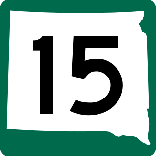
South Dakota Highway 15 (SD 15) is a 67.562-mile-long (108.730 km) state highway in the northeastern South Dakota, United States. It connects Clear Lake, Milbank, and Wilmot.

South Dakota Highway 20 (SD 20) is a 385.079-mile (619.725 km) state highway in northern South Dakota, United States, that connects the Montana state line, west-southwest of Camp Crook, with the Minnesota state line, east-southeast of Revillo, via Buffalo, Bison, Timber Lake, Mobridge, Selby, and Watertown. From Mobridge to the Walworth–Potter county line, this highway is part of the Lewis and Clark Trail. From about Timber Lake to just west of Mobridge, this highway is part of the Native American Scenic Byway. From the Montana state line to Camp Crook, the highway is a dirt road.
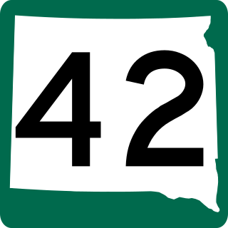
South Dakota Highway 42 (SD 42) is a segmented state highway in southeastern South Dakota, United States. The first segment is a six-mile-long (9.7 km) highway in Aurora County. The second and longest is 60 miles (97 km) long and connects Ethan and Sioux Falls. The final segment connects Sioux Falls to Iowa Highway 9 southeast of Rowena.
Zell is an unincorporated community in Faulk County, South Dakota, United States, astride U.S. Route 212. It was once a stop on the old Chicago and North Western Railway.

The Clearwater River is in the northwestern United States, in north central Idaho. Its length is 74.8 miles (120.4 km), it flows westward from the Bitterroot Mountains along the Idaho-Montana border, and joins the Snake River at Lewiston. In October 1805, the Lewis and Clark Expedition descended the Clearwater River in dugout canoes, putting in at "Canoe Camp," five miles (8 km) downstream from Orofino; they reached the Columbia Bar and the Pacific Ocean about six weeks later.
Crandon is an unincorporated community in Spink County, in the U.S. state of South Dakota.
Lucas is an unincorporated community in Gregory County, in the U.S. state of South Dakota. The community is located approximately eight miles west of Lake Francis Case between the north and south forks of Whetstone Creek. Gregory lies approximately 12 miles to the west-southwest and Burke lies about seven miles to the south-southwest.