Pearl Creek Colony is a Hutterite colony and census-designated place (CDP) in Beadle County, South Dakota, United States. It was first listed as a CDP prior to the 2020 census. The population of the CDP was 99 at the 2020 census.
Newdale Colony is a Hutterite colony and census-designated place (CDP) in Brookings County, South Dakota, United States. It was first listed as a CDP prior to the 2020 census. The population of the CDP was 6 at the 2020 census.
Norfeld Colony is a Hutterite colony and census-designated place (CDP) in Brookings County, South Dakota, United States. It was first listed as a CDP prior to the 2020 census. The population of the CDP was 9 at the 2020 census.
Rolland Colony is a Hutterite colony and census-designated place (CDP) in Brookings County, South Dakota, United States. It was first listed as a CDP prior to the 2020 census. The population of the CDP was 53 at the 2020 census.
Lakeview Colony is a Hutterite colony and census-designated place (CDP) within the Yankton Indian Reservation in Charles Mix County, South Dakota, United States. It was first listed as a CDP prior to the 2020 census. The population of the CDP was 0 at the 2020 census.
Mayfield Colony is a Hutterite colony and census-designated place (CDP) in Clark County, South Dakota, United States. The population was 146 at the 2020 census. It was first listed as a CDP prior to the 2020 census.
Silver Lake Colony is a Hutterite colony and census-designated place (CDP) in Clark County, South Dakota, United States. The population was 7 at the 2020 census. It was first listed as a CDP prior to the 2020 census.
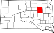
Claremont Colony is a Hutterite colony and census-designated place (CDP) in Hamlin County, South Dakota, United States. The population was 68 at the 2020 census. It was first listed as a CDP prior to the 2020 census.
New Elm Spring Colony is a Hutterite colony and census-designated place (CDP) in Hutchinson County, South Dakota, United States. The population was 100 at the 2020 census. It was first listed as a CDP prior to the 2020 census.
Old Elm Spring Colony is a Hutterite colony and census-designated place (CDP) in Hutchinson County, South Dakota, United States. The population was 114 at the 2020 census. It was first listed as a CDP prior to the 2020 census.
Wolf Creek Colony is a Hutterite colony and census-designated place (CDP) in Hutchinson County, South Dakota, United States. The population was 0 at the 2020 census. It was first listed as a CDP prior to the 2020 census.
Graceville Colony is a census-designated place (CDP) corresponding to the Gracevale Hutterite colony in Lake County, South Dakota, United States. The population was 21 at the 2020 census. It was first listed as a CDP prior to the 2020 census.
Newport Colony is a Hutterite colony and census-designated place (CDP) in Marshall County, South Dakota, United States. The population was 114 at the 2020 census. It was first listed as a CDP prior to the 2020 census.
Pleasant Valley Colony is a census-designated place (CDP) and Hutterite colony in Moody County, South Dakota, United States. The population was 6 at the 2020 census. It was first listed as a CDP prior to the 2020 census.
White Rock Colony is a census-designated place (CDP) and Hutterite colony in Roberts County, South Dakota, United States, partly within the Lake Traverse Indian Reservation. It was first listed as a CDP prior to the 2020 census. The population of the CDP was 0 at the 2020 census.
Upland Colony is a census-designated place (CDP) and Hutterite colony in Sanborn County, South Dakota, United States. It was first listed as a CDP prior to the 2020 census. The population of the CDP was 178 at the 2020 census.
Clark Colony is a census-designated place (CDP) and Hutterite colony in Spink County, South Dakota, United States. It was first listed as a CDP prior to the 2020 census. The population of the CDP was 92 at the 2020 census.
Glendale Colony is a census-designated place (CDP) and Hutterite colony in Spink County, South Dakota, United States. It was first listed as a CDP prior to the 2020 census. The population of the CDP was 176 at the 2020 census.
Hillside Colony is a census-designated place (CDP) and Hutterite colony in Spink County, South Dakota, United States. It was first listed as a CDP prior to the 2020 census. The population of the CDP was 123 at the 2020 census.
Spink Colony is a census-designated place (CDP) and Hutterite colony in Spink County, South Dakota, United States. It was first listed as a CDP before the 2020 census. The population of the CDP was 135 at the 2020 Census.