Newdale Colony is a Hutterite colony and census-designated place (CDP) in Brookings County, South Dakota, United States. It was first listed as a CDP prior to the 2020 census. The population of the CDP was 6 at the 2020 census.
Norfeld Colony is a Hutterite colony and census-designated place (CDP) in Brookings County, South Dakota, United States. It was first listed as a CDP prior to the 2020 census. The population of the CDP was 9 at the 2020 census.
Rolland Colony is a Hutterite colony and census-designated place (CDP) in Brookings County, South Dakota, United States. It was first listed as a CDP prior to the 2020 census. The population of the CDP was 53 at the 2020 census.
Hutterville Colony is a Hutterite colony and census-designated place (CDP) in Brown County, South Dakota, United States. It was first listed as a CDP prior to the 2020 census. The CDP had a population of 95 at the 2020 census.
Cedar Grove Colony is a Hutterite colony and census-designated place (CDP) in Brule County, South Dakota, United States. The population was 0 at the 2020 census. It was first listed as a CDP prior to the 2020 census.
Clearfield Colony is a Hutterite colony and census-designated place (CDP) within the Yankton Indian Reservation in Charles Mix County, South Dakota, United States. It was first listed as a CDP prior to the 2020 census. The population of the CDP was 99 at the 2020 census.
Platte Colony is a Hutterite colony and census-designated place (CDP) in Charles Mix County, South Dakota, United States. It was first listed as a CDP prior to the 2020 census. The population of the CDP was 299 at the 2020 census.
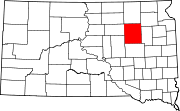
Collins Colony is a Hutterite colony and census-designated place (CDP) in Clark County, South Dakota, United States. The population was 92 at the 2020 census. It was first listed as a CDP prior to the 2020 census.
Mayfield Colony is a Hutterite colony and census-designated place (CDP) in Clark County, South Dakota, United States. The population was 146 at the 2020 census. It was first listed as a CDP prior to the 2020 census.
Newport Colony is a Hutterite colony and census-designated place (CDP) in Marshall County, South Dakota, United States. The population was 114 at the 2020 census. It was first listed as a CDP prior to the 2020 census.
Westwood Colony is a Hutterite colony and census-designated place (CDP) in Marshall County, South Dakota, United States. The population was 8 at the 2020 census. It was first listed as a CDP prior to the 2020 census.
Orland Colony is a census-designated place (CDP) and Hutterite colony in McCook County, South Dakota, United States. The population was 2 at the 2020 census. It was first listed as a CDP prior to the 2020 census.
Grassland Colony is a census-designated place (CDP) and Hutterite colony in McPherson County, South Dakota, United States. It was first listed as a CDP prior to the 2020 census. The population of the CDP was 127 at the 2020 census.
Long Lake Colony is a census-designated place (CDP) and Hutterite colony in McPherson County, South Dakota, United States. It was first listed as a CDP prior to the 2020 census. The population of the CDP was 8 at the 2020 census.
Cloverleaf Colony is a census-designated place (CDP) and former Hutterite colony in Miner County, South Dakota, United States. It was first listed as a CDP prior to the 2020 census. The population of the CDP was 16 at the 2020 census.
Shannon Colony is a census-designated place (CDP) and Hutterite colony in Miner County, South Dakota, United States. It was first listed as a CDP prior to the 2020 census. The population of the CDP was 1 at the 2020 census.
Camrose Colony is a census-designated place (CDP) and Hutterite colony in Spink County, South Dakota, United States. It was first listed as a CDP prior to the 2020 census. The CDP had a population of 76 at the 2020 census.
Clark Colony is a census-designated place (CDP) and Hutterite colony in Spink County, South Dakota, United States. It was first listed as a CDP prior to the 2020 census. The population of the CDP was 92 at the 2020 census.
Hillside Colony is a census-designated place (CDP) and Hutterite colony in Spink County, South Dakota, United States. It was first listed as a CDP prior to the 2020 census. The population of the CDP was 123 at the 2020 census.
Spink Colony is a census-designated place (CDP) and Hutterite colony in Spink County, South Dakota, United States. It was first listed as a CDP before the 2020 census. The population of the CDP was 135 at the 2020 Census.