Atlantic Northeast

Last updated

Atlantic Northeast
Boston skyline from Longfellow Bridge September 2017 panorama 2.jpg
Bass Harbor Lighthouse.jpg
Western Brook Pond Newfoundland Canada DSC 6405.jpg
Montreal August 2017 05.jpg
NB Fundy3 tango7174.jpg
WinterWashington.jpg
Halifax Harbour Sunset Skyline, Nova Scotia (24237034620).jpg
Nickname: 
Atlantica
New England Governors and Eastern Canadian Premiers Conference members.svg
Countries Canada and United States
States/Provinces
Territories
Largest metropolitan areas
Languages

The Atlantic Northeast (French : Atlantique nord-est) is a geographic and cultural region of eastern North America bounded by the Atlantic Ocean to the east and (loosely) by the Saint Lawrence River to the northwest. Though no official boundary exists, the most common conception includes the Maritime provinces, southern Quebec, and the island of Newfoundland in Canada, and the New England region of the United States. Broader conceptions reach further north into Canada, including Labrador and the Côte-Nord region of Quebec. Narrower conceptions may be limited to the coastal areas east of the Appalachian Mountains. The variety of definitions can be attributed to overlapping commonalities of the region's history, culture, geography, ecology, society, and other factors.

Contents

Definition

The term "Atlantic Northeast" should not be confused with Atlantic Canada, which includes the entirety of New Brunswick, Newfoundland and Labrador, Nova Scotia, and Prince Edward Island, but excludes Quebec. It should also not be confused with the northeastern portion of the Atlantic Ocean.

History

The predominant nations in the region over the course of the estimated last 11,000 years have been the Abenaki, Penobscot, Mi'kmaq, Maliseet, and Passamaquoddy, all of whom were later associated with the Wabanaki Confederacy. [1] These nations' countries mainly overlapped the soon-to-be Maritime provinces, such as Mi'kma'ki and Wolastokuk with New Brunswick, Nova Scotia, and Prince Edward Island, as well as Ndakinna, Peskotomuhkatik, and Pαnawαhpskewahki with Vermont, New Hampshire, and Massachusetts.

Before 1620 the conflicts between First Nations and English settlers started due to the alienation of tribes; they also kidnapped members of the tribes through violence. [2] The violence confused many Indigenous nations because they also traded with proper settlers, but this left the First Nations resentful of the European nations. [2] The presence of the French and English in the Atlantic Northeast attracted the Dutch to begin trading on the Hudson River with different peoples. The new presence of these traders also brought unwanted microbes, viruses, and bacteria that took a disastrous toll on the Indigenous populations. [1] When smallpox swept the New England area in 1610, the native population hit an all-time low, since they were trying to fight off a virus that was not indigenous to the area. [3] Eventually the population recovered but not completely. After the outbreak settlers became highly interested in the Wabanaki beaver pelts, which they would trade for glass, metal, and weapons. [4]

During the period of the expulsion of the Acadians, thousands were deported from the present-day Canadian provinces of Nova Scotia, New Brunswick, and PEI, as well as from northern Maine — parts of the French region called Acadie — into the Thirteen Colonies, from 1755 until 1758. Large parts of Nova Scotia were subsequently resettled by new arrivals from New England before 1775. [5] At the end of the American Revolution, nearly 75,000 Loyalists resettled in Nova Scotia, New Brunswick and Québec. Close to 3,500 free African Americans went to Nova Scotia. Before 1860, about 30,000–40,000 black people entered Canada, many of them joining the previous group in Nova Scotia, either free or as escaped slaves through the Underground Railroad. [6] From the mid-19th century until the Great Depression in the 1930s, nearly 900,000 French Canadians emigrated from Québec to the U.S. Two-thirds went into New England mill towns. [7]

Geography

Major geographical features of the Atlantic Northeast include the Appalachian Mountains, the Green Mountains, the Atlantic Ocean, Long Island Sound, the Gulf of Maine, the Gulf of Saint Lawrence, the Bay of Fundy, the Merrimack River, the Boston Harbor, the Taunton River, the Blackstone River, the Connecticut River, the Housatonic River, and the Hoosic River. [8]

Border disputes

The "Gray Zone" is an area of land and sea which is claimed by both Canada and the United States. It is located off the coasts of New Brunswick and Maine. The only land within this area are two islands, Machias Seal Island and North Rock. The "Gray Zone" is one of four areas between the two countries whose sovereignty is still in dispute, but is the only one of the disputed areas containing land. In 1979, both countries filed a joint application to the International Court of Justice to avoid having the dispute settled when oceanic boundaries in the area were set for mineral and fishing rights. Canadians have had a continuous presence in the area since 1832 when a lighthouse was built. [9] [10]

Places of interest

The Maritimes in the Atlantic Northeast Carte administrative de l'Acadie.svg
The Maritimes in the Atlantic Northeast

Northeast Canyons and Seamounts Marine National Monument is located 150 miles (240 km) off the shore of Cape Cod. The national monument comprises 4,900 square miles (13,000 km2) of underwater canyons carved into the continental shelf, and has an underwater mountain rising 7,000 feet (2,100 m) above the ocean floor. This monument is home to many marine species, fish, whales, and dolphins. The monument was formed by a declaration by President Barack Obama. [11]

Salem, Massachusetts, is a famous location in New England known primarily for the Salem witch trials. It was also one of Massachusetts' wealthiest ports for trading in the late 18th century. [8]

Acadia National Park is on Mount Desert Island in Maine, with 47,000 acres (19,000 ha) of woodlands, rocky shoreline, trails, camping, and wildlife. The park is home to Cadillac Mountain, the highest mountain on the east coast of the United States. [12]

Climate

The Atlantic Northeast region has a four-season climate. In the New England region of the United States, summers are hot with an average temperature of 80–85 °F (27–29 °C) in late June through August. In the fall the air is cool, with temperatures from 45 to 50 °F (7 to 10 °C), and in the spring it tends to be rainy, with temperatures from 40 to 60 °F (4 to 16 °C). In the winter there tends to be a lot of snowfall averaging around 35 inches (890 mm) per year. The typical temperature in this area during the winter is around 25 °F (−4 °C). [13] The Canadian Maritimes have seasons very similar to the New England areas. New Brunswick has cold winters ranging from approximately 19–31 °F (−7 – −1 °C) and hot summers with temperatures from 72 to 77 °F (22 to 25 °C). Prince Edward Island has a climate similar to New Brunswick with temperatures ranging from 46 to 71 °F (8 to 22 °C) in the summer and 11 to 26 °F (−12 to −3 °C) in the winter. [14] In the summer in Nova Scotia temperatures will reach around 75 °F (24 °C), and in the winter temperatures will drop as low as 24 °F (−4 °C). [15]

Demographics

Most of the region's population is concentrated in southwestern New England and the Saint Lawrence Lowlands of Quebec, both of which form the northern part of their respective country's largest megalopolises. The region's largest metropolitan areas are Greater Boston, Massachusetts, with 4.8 million people; [16] Greater Montreal, Quebec, with 4.1 million people; [17] Greater Providence, Rhode Island, with 1.62 million people; [18] and Greater Hartford, Connecticut, with 1.21 million people. [19]

Largest cities and metropolitan areas

This is a list of the most populous cities and metropolitan areas in the Atlantic Northeast based on the 2016 Canadian Census [20] [21] and United States Census Bureau population estimates as of July 1, 2019. [22] [23] [24] [25]

CityState/ProvincePopulation Metropolitan area
Montreal Quebec 1,704,6944,098,927
Boston Massachusetts 692,6004,875,390
Quebec City Quebec531,902800,296
Laval Quebec422,993 [n 1]
Halifax Nova Scotia 316,701403,131
Longueuil Quebec239,700 [n 1]
Worcester Massachusetts185,428923,672
Providence Rhode Island 179,8831,609,359
St. John's Newfoundland and Labrador 178,427205,955
Sherbrooke Quebec161,323212,105
Springfield Massachusetts153,606692,942
Saguenay Quebec145,949160,980
Bridgeport Connecticut 144,399939,904
Lévis Quebec143,414 [n 2]
Trois-Rivières Quebec134,413156,042
New Haven Connecticut130,250862,477
Stamford Connecticut129,638 [n 3]
Hartford Connecticut122,1051,214,295
Cambridge Massachusetts118,927 [n 4]
Manchester New Hampshire 112,673406,678
Terrebonne Quebec111,575 [n 1]
Lowell Massachusetts110,997 [n 4]
Moncton New Brunswick 108,620144,810
Waterbury Connecticut107,568 [n 5]

Notes


Culture

Sports

New England PatriotsNew England RevolutionBoston CelticsBoston BruinsBoston Red SoxHalifax HurricanesMontreal Canadiens
Home stadiumGillette StadiumGillette StadiumTD GardenTD GardenFenway ParkScotiabank CentreBell Centre
Home locationFoxboro, MassachusettsFoxboro, MassachusettsBoston, MassachusettsBoston, MassachusettsBoston, MassachusettsHalifax, Nova ScotiaMontreal, Québec
Championships won611769124
Sports leagueNational Football LeagueMajor League SoccerNational Basketball AssociationNational Hockey LeagueMajor League BaseballNational Basketball LeagueNational Hockey League
Year established1960199519461924190120071909

[26] [27]

Historical landmarks

Alexander Graham Bell National Historic Site in Baddeck, Cape Breton Island, Nova Scotia, commemorates Alexander Graham Bell, a remarkable inventor who created Canada's first engine-powered airplane, the world's fastest boat, and the world's first telephone, along with many other achievements. [28]

The Freedom Trail USA-The Freedom Trail.JPG
The Freedom Trail

Halifax Citadel National Historic Site is the site of Fort George in Halifax, Nova Scotia. Visitors can take tours of the fort, learning about its soldiers, its legends and ghost stories, and even become a soldier for the day. [29]

The Freedom Trail is a two and a half mile walking trail through the city of Boston that takes visitors past sixteen historic sites that led to the American Revolution, including the Boston Common, the Park Street Church, the Granary Burying Ground, King's Chapel, the Old Corner Bookstore, the Old State House, the site of the Boston Massacre, Faneuil Hall, the Paul Revere House, the Old North Church, the USS Constitution, and the Bunker Hill Monument. [30]

The Salem Witch Museum describes the history of the Salem witch trials of 1692 through life-size figures and narrations. [30]

The First Baptist Church in America was founded in Providence, Rhode Island, in 1638 by William Vincent Carpenter and Roger Williams and was later rebuilt in 1774. Guided tours are available from Memorial Day through Labor Day on weekdays, and self tours of the landmark are available all year round. [30]

The Lake Champlain Maritime Museum, in Vergennes, Vermont, open from May to October, houses historic schooners, steamboats, wooden boats, shipwrecks, and even a Revolutionary War gunboat replica. Visitors can learn about the history of the lake's role in commerce, communication, transportation, and war, as well as its natural history above and below sea level. [30]

Charlottetown City Hall is the oldest municipal building on Prince Edward Island, built in 1888. Visitors can tour the City Hall to learn about the history and present day of Prince Edward Island and the city of Charlottetown. [31]

Transportation

Sections owned by Amtrak are in red; sections with commuter service are highlighted in blue. NEC map.svg
Sections owned by Amtrak are in red; sections with commuter service are highlighted in blue.

Wildlife

Birds

Piping Plover Piping plover.jpg
Piping Plover

In the Atlantic Northeast it is common to see many birds living in the region, including bald eagles (Haliaeetus leucocephalus), piping plovers (Atlantic coast) (Charadrius melodus), the red-cockaded woodpecker (Picoides borealis), the red knot (Calidris canutus rufa), the North American subspecies of the roseate tern (Sterna dougallii dougallii), and shorebirds. [32]

Aquatic life

Atlantic horseshoe crab Limulus polyphemus (aq.).jpg
Atlantic horseshoe crab

The aquatic life in the Atlantic Northeast is quite extensive. The more common animals that are found in the area include the American eel (Anguilla rostrata), Appalachian monkey-face pearly mussel ( Theliderma sparsa ), dwarf wedgemussel (Alasmidonta heterodon), Atlantic horseshoe crab (Limulus polyphemus), Kenk's amphipod (Stygobromus kenki), and northern red-bellied cooter (Pseudemys rubriventris). [33] [ failed verification ]

Plants

Swamp Pink (Helonias bullata) Helonias bullata FWS.jpg
Swamp Pink (Helonias bullata)

The plant life in the Atlantic Northeast is quite varied due to the turbulent climate in that area, but some of the more common plant life includes such species as Furbish lousewort ( Pedicularis furbishiae ), Jesup's milk-vetch ( Astragalus robbinsii var. jesupii), and Northeastern bulrush ( Scirpus ancistrochaetus ). [34] [ failed verification ]

See also

Related Research Articles

<span class="mw-page-title-main">The Maritimes</span> Region of Atlantic Canada

The Maritimes, also called the Maritime provinces, is a region of Eastern Canada consisting of three provinces: New Brunswick, Nova Scotia, and Prince Edward Island. The Maritimes had a population of 1,899,324 in 2021, which makes up 5.1% of Canada's population. Together with Canada's easternmost province, Newfoundland and Labrador, the Maritime provinces make up the region of Atlantic Canada.

<span class="mw-page-title-main">Maine</span> U.S. state

Maine is the easternmost state in the New England region of the Northeastern United States. It borders New Hampshire to the west, the Gulf of Maine to the southeast, and the Canadian provinces of New Brunswick and Quebec to the northeast and northwest, respectively. Maine is the largest state in New England by total area. Of the 50 U.S. states, it is the 12th-smallest by area, the 9th-least populous, the 13th-least densely populated, and the most rural. Maine's capital is Augusta, and its most populous city is Portland, with a total population of 68,408, as of the 2020 census.

<span class="mw-page-title-main">Nova Scotia</span> Province of Canada

Nova Scotia is one of the thirteen provinces and territories of Canada. It is one of the three Maritime provinces and one of the four Atlantic provinces. Nova Scotia is Latin for "New Scotland".

<span class="mw-page-title-main">Acadians</span> Descendants of the 17th-century French colonists who settled in Acadia

The Acadians are an ethnic group descended from the French who settled in the New France colony of Acadia during the 17th and 18th centuries.

<span class="mw-page-title-main">Atlantic Canada</span> Region of Eastern Canada

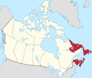
Atlantic Canada, also called the Atlantic provinces, is the region of Eastern Canada comprising the provinces located on the Atlantic coast, excluding Quebec. The four provinces are New Brunswick, Newfoundland and Labrador, Nova Scotia, and Prince Edward Island. As of 2021, the landmass of the four Atlantic provinces was approximately 488,000 km2 (188,000 sq mi), and had a population of over 2.4 million people. The provinces combined had an approximate GDP of $121.888 billion in 2011. The term Atlantic Canada was popularized following the admission of Newfoundland as a Canadian province in 1949.

<span class="mw-page-title-main">Acadia</span> Colony of New France in northwestern North America

Acadia was a colony of New France in northeastern North America which included parts of what are now the Maritime provinces, the Gaspé Peninsula and Maine to the Kennebec River.

<span class="mw-page-title-main">Miramichi, New Brunswick</span> City in New Brunswick, Canada

Miramichi ( ) is the largest city in northern New Brunswick, Canada. It is situated at the mouth of the Miramichi River where it enters Miramichi Bay. The Miramichi Valley is the second longest valley in New Brunswick, after the Saint John River Valley.

<span class="mw-page-title-main">British North America</span> Former British imperial territories

British North America comprised the colonial territories of the British Empire in North America from 1783 onwards. English colonisation of North America began in the 16th century in Newfoundland, then further south at Roanoke and Jamestown, Virginia, and more substantially with the founding of the Thirteen Colonies along the Atlantic coast of North America.

<span class="mw-page-title-main">Amherst, Nova Scotia</span> Town in Nova Scotia, Canada

Amherst is a town in northwestern Nova Scotia, Canada, located at the northeast end of the Cumberland Basin, an arm of the Bay of Fundy, and 22 km (14 mi) south of the Northumberland Strait. The town sits on a height of land at the eastern boundary of the Isthmus of Chignecto and Tantramar Marshes, 3 km (1.9 mi) east of the interprovincial border with New Brunswick and 65 km (40 mi) southeast of the city of Moncton. It is 60 km (37 mi) southwest of the New Brunswick abutment of the Confederation Bridge to Prince Edward Island at Cape Jourimain.

<span class="mw-page-title-main">Yarmouth, Nova Scotia</span> Town in Nova Scotia, Canada

Yarmouth is a town in southwestern Nova Scotia, Canada. A port town, its industries include fishing and tourism. It is the terminus of a ferry service to Bar Harbor, Maine, run by Bay Ferries.

<span class="mw-page-title-main">Gulf of Maine</span> Large gulf of the Atlantic Ocean on the east coast of North America

The Gulf of Maine is a large gulf of the Atlantic Ocean on the east coast of North America. It is bounded by Cape Cod at the eastern tip of Massachusetts in the southwest and by Cape Sable Island at the southern tip of Nova Scotia in the northeast. The gulf includes the entire coastlines of the U.S. states of New Hampshire and Maine, as well as Massachusetts north of Cape Cod, and the southern and western coastlines of the Canadian provinces of New Brunswick and Nova Scotia, respectively.

<span class="mw-page-title-main">Halifax, Nova Scotia</span> Capital and most populous municipality of Nova Scotia, Canada

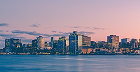
Halifax is the capital and largest municipality of the Canadian province of Nova Scotia, and the largest municipality in Atlantic Canada. As of 2022, it is estimated that the population of the Halifax CMA was 480,582, with 348,634 people in its urban area. The regional municipality consists of four former municipalities that were amalgamated in 1996: Halifax, Dartmouth, Bedford, and Halifax County.

<span class="mw-page-title-main">Greater Boston</span> Metropolitan area in the United States

Greater Boston is the metropolitan region of New England encompassing the municipality of Boston, the capital of the U.S. state of Massachusetts and the most populous city in New England, and its surrounding areas. The region forms the northern arc of the Northeast megalopolis, making Greater Boston both a metropolitan statistical area (MSA) and a combined statistical area (CSA). The most stringent definition of the region consists of most of the eastern third of mainland Massachusetts, excluding the Merrimack Valley and South Coast; while the most expansive definition includes these plus Cape Cod, Central Massachusetts, Rhode Island, southeastern New Hampshire, and Windham County, Connecticut.

<span class="mw-page-title-main">Maritime Union</span> Proposed political union of New Brunswick, Nova Scotia and Prince Edward Island

Maritime Union is a proposed political union of the three Maritime provinces of Canada – New Brunswick, Nova Scotia, and Prince Edward Island – to form a single new province.

<span class="mw-page-title-main">Dummer's War</span> Conflict between the New England Colonies and the Wabanaki Confederacy (1722–25)

Dummer's War (1722–1725) was a series of battles between the New England Colonies and the Wabanaki Confederacy, who were allied with New France. The eastern theater of the war was located primarily along the border between New England and Acadia in Maine, as well as in Nova Scotia; the western theater was located in northern Massachusetts and Vermont at the border between Canada and New England. During this time, Maine and Vermont were part of Massachusetts.

<span class="mw-page-title-main">Eastern Canada</span> Region of Canada

Eastern Canada is generally considered to be the region of Canada south of Hudson Bay/Hudson Strait and east of Manitoba, consisting of the following provinces : Newfoundland and Labrador, Nova Scotia, Prince Edward Island, New Brunswick, Quebec and Ontario.

<span class="mw-page-title-main">Indigenous peoples of the Northeastern Woodlands</span> Native peoples in Eastern Canada and Northeastern United States

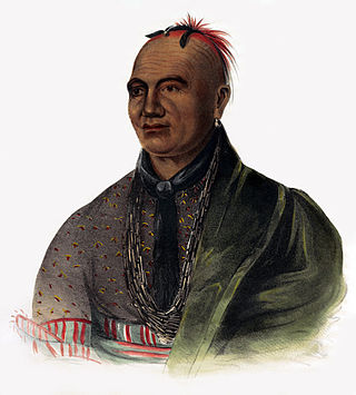
Indigenous peoples of the Northeastern Woodlands include Native American tribes and First Nation bands residing in or originating from a cultural area encompassing the northeastern and Midwest United States and southeastern Canada. It is part of a broader grouping known as the Eastern Woodlands. The Northeastern Woodlands is divided into three major areas: the Coastal, Saint Lawrence Lowlands, and Great Lakes-Riverine zones.

<span class="mw-page-title-main">Atlantica (trade zone)</span>

Atlantica, formally known as Atlantica: the International Northeast Economic Region (AINER), is the name of a proposed area of economic integration in the Atlantic Northeast of North America, incorporating parts of Canada and the United States.

<span class="mw-page-title-main">New England–Acadian forests</span> Temperate broadleaf and mixed forest ecoregion of Canada and the United States

The New England-Acadian forests are a temperate broadleaf and mixed forest ecoregion in North America that includes a variety of habitats on the hills, mountains and plateaus of New England and New York State in the Northeastern United States, and Quebec and the Maritime Provinces of Eastern Canada.

<span class="mw-page-title-main">Maritime Peninsula</span>

The Maritime Peninsula is a region of eastern North America that extends from the Kennebec River in the U.S. state of Maine northeast to the Maritime provinces of Canada and Quebec's Gaspé Peninsula. It is bounded by the Gulf of Saint Lawrence to the north and the Gulf of Maine to the south.

References

  1. 1 2 Hoxie, Frederick (2016). The Oxford Handbook of American Indian History. Oxford University Press. ISBN   9780199858897.
  2. 1 2 Hoxie, F.E. (2016). The Oxford Handbook of American Indian History. Oxford Handbooks. Oxford University Press. p. 340. ISBN   978-0-19-061402-7 . Retrieved February 19, 2023.
  3. Pestana, C.G. (2015). Inequality in Early America. Reencounters with Colonialism: New Perspectives on the Americas. Dartmouth College Press. p. 114. ISBN   978-1-61168-692-0 . Retrieved February 19, 2023.
  4. American Friends Service Committee (1989). The Wabanakis of Maine and the Maritimes: A Resource Book about Penobscot, Passamaquoddy, Maliseet, Micmac and Abenaki Indians; with Lesson Plans for Grades 4 Through 8. The Program. p. 21.
  5. John Brebner, The Neutral Yankees of Nova Scotia: A Marginal Colony During the Revolutionary Years (1937)
  6. Patrick Bode, "Upper Canada, 1793: Simcoe and the Slaves," Beaver 1993 73(3): 17–19; Paul Robert Magocsi, ed. Encyclopedia of Canada's Peoples (1999) p 142–3
  7. David Vermette, A Distinct Alien Race: The Untold Story of Franco-Americans: Industrialization, Immigration, Religious Strife (2018)
  8. 1 2 "Discover New England". Discover New England.org. Nancy Marshall Communications. Archived from the original on November 15, 2016. Retrieved November 15, 2016.
  9. "The Border Isn't As Clear As You Think". The Huffington Post. December 23, 2012. Retrieved November 15, 2016.
  10. "U.S.-Canada Border: History, Disputes & More". Sovereign Limits. October 30, 2018. Retrieved June 2, 2022.
  11. "Letter-writers make history: President Obama declares first Atlantic Ocean National Monument". National Geographic. Archived from the original on September 23, 2016.
  12. "The First Eastern National Park". NPS.gov. American government.
  13. "Facts About New England, USA | Discover New England". www.discovernewengland.org. Archived from the original on November 15, 2016. Retrieved November 15, 2016.
  14. Canada, Province of Prince Edward Island. "Government of PEI: What's the weather like?". www.gov.pe.ca. Retrieved November 15, 2016.
  15. "Average Temperature in Nova Scotia" . Retrieved November 15, 2016.
  16. "County Population Totals and Components of Change: 2010-2018". United States Census Bureau. Retrieved October 4, 2019.
  17. "Population and dwelling counts, for census metropolitan areas, 2016 and 2011 censuses – 100% data". Statistics Canada. Government of Canada. February 8, 2017. Archived from the original on February 11, 2017. Retrieved February 14, 2017.
  18. "Annual Estimates of the Resident Population: April 1, 2010 to July 1, 2019". United States Census Bureau. April 2, 2020. Retrieved April 27, 2020.
  19. "2019 U.S. Gazetteer Files". United States Census Bureau. Retrieved July 2, 2020.
  20. "Population counts, for census metropolitan areas, census agglomerations, population centres and rural areas, 2016 Census". Statistics Canada. February 8, 2017. Retrieved February 8, 2017.
  21. "Population and dwelling counts, for Canada, provinces and territories, census metropolitan areas and census agglomerations, 2016 and 2011 censuses – 100% data". Statistics Canada. February 8, 2017. Retrieved February 8, 2017.
  22. "Connecticut Subcounty Resident Population Estimates: April 1, 2010 to July 1, 2019". U.S. Census Bureau. Retrieved July 24, 2020.
  23. "Massachusetts Subcounty Resident Population Estimates: April 1, 2010 to July 1, 2019". U.S. Census Bureau. Retrieved July 24, 2020.
  24. "New Hampshire Subcounty Resident Population Estimates: April 1, 2010 to July 1, 2019". U.S. Census Bureau. Retrieved July 24, 2020.
  25. "Rhode Island Subcounty Resident Population Estimates: April 1, 2010 to July 1, 2019". U.S. Census Bureau. Retrieved July 24, 2020.
  26. "Massachusetts Sports Teams | Boston Sports Teams" . Retrieved November 15, 2016.
  27. "Home". www.halifaxhurricanes.ca. Archived from the original on July 19, 2017. Retrieved November 15, 2016.
  28. "Alexander Graham Bell National Historic Site". Tourism Nova Scotia. Retrieved November 15, 2016.
  29. "Halifax Citadel National Historic Site". Tourism Nova Scotia. Retrieved November 15, 2016.
  30. 1 2 3 4 "Colonial New England | Tours of Cities, Parks, Museums, Architecture". www.visitnewengland.com. Retrieved November 15, 2016.
  31. "Discover Charlottetown - See map". www.discovercharlottetown.com. Archived from the original on April 27, 2017. Retrieved November 16, 2016.
  32. "North Atlantic - Appalachian Region". Northeast Region, U.S. Fish and Wildlife Service. December 7, 2020.
  33. "Energy and Environmental affairs". Mass.gov. Massachusetts Division of Fisheries and Wildlife.
  34. "Energy and Environmental Affairs". Mass.gov. American government.

43°40′50″N70°44′01″W / 43.6806°N 70.7336°W / 43.6806; -70.7336