Aurelia, Iowa

Last updated

Aurelia, Iowa
Bandstand, Aurelia, Iowa LCCN2017706061.tif
Bandstand in Aurelia
Cherokee County Iowa Incorporated and Unincorporated areas Aurelia Highlighted.svg
Location of Aurelia, Iowa
Coordinates: 42°42′51″N95°26′5″W / 42.71417°N 95.43472°W / 42.71417; -95.43472
Country Flag of the United States.svg  United States
State Flag of Iowa.svg  Iowa
County Cherokee
Area
[1]
  Total1.01 sq mi (2.63 km2)
  Land1.01 sq mi (2.63 km2)
  Water0.00 sq mi (0.00 km2)
Elevation
1,391 ft (424 m)
Population
 (2020)
  Total968
  Density954.64/sq mi (368.44/km2)
Time zone UTC-6 (Central (CST))
  Summer (DST) UTC-5 (CDT)
ZIP code
51005
Area code 712
FIPS code 19-03745
GNIS feature ID0454283

Aurelia is a city in Cherokee County, Iowa, United States. The population was 968 at the 2020 census. [2]

Contents

History

Aurelia was founded in 1873 as a stop along the Illinois Central Railroad branch connecting Sioux City, Iowa, to Chicago, Illinois. This was the only railroad connecting the two Midwestern hubs and so gave birth to many railroad towns. Aurelia was named for the youngest daughter of the owner of the railroad, John Insley Blair, who died in 1866. [3] The location of Aurelia was only set after a last minute change in the railroad design that saw it redirect to go through LeMars and Cherokee, rather than connect Sioux City directly to Storm Lake. Almost 70% of Aurelia's population is people over age 50. Its newspaper is the Aurelia Star which was founded in March 1881 as the Aurelia Sentinel.

Geography

Aurelia is located at 42°42′51″N95°26′05″W / 42.714055°N 95.434696°W / 42.714055; -95.434696 . [4]

According to the United States Census Bureau, the city has a total area of 1.04 square miles (2.69 km2), all land. [5]

Demographics

Historical population
CensusPop.Note
1880 225
1890 663194.7%
1900 621−6.3%
1910 6250.6%
1920 70813.3%
1930 7232.1%
1940 7524.0%
1950 8077.3%
1960 90412.0%
1970 1,06517.8%
1980 1,1437.3%
1990 1,034−9.5%
2000 1,0622.7%
2010 1,036−2.4%
2020 968−6.6%
U.S. Decennial Census [6] [2]
The population of Aurelia, Iowa from US census data AureliaIowaPopPlot.png
The population of Aurelia, Iowa from US census data

2010 census

As of the census [7] of 2010, there were 1,036 people, 426 households, and 299 families living in the city. The population density was 996.2 inhabitants per square mile (384.6/km2). There were 447 housing units at an average density of 429.8 per square mile (165.9/km2). The racial makeup of the city was 96.3% White, 0.3% African American, 0.2% Native American, 0.6% Asian, 1.6% from other races, and 1.0% from two or more races. Hispanic or Latino of any race were 2.6% of the population.

There were 426 households, of which 27.7% had children under the age of 18 living with them, 59.9% were married couples living together, 7.5% had a female householder with no husband present, 2.8% had a male householder with no wife present, and 29.8% were non-families. 26.8% of all households were made up of individuals, and 13.6% had someone living alone who was 65 years of age or older. The average household size was 2.35 and the average family size was 2.84.

The median age in the city was 45.2 years. 22.6% of residents were under the age of 18; 6.6% were between the ages of 18 and 24; 20.4% were from 25 to 44; 26.4% were from 45 to 64; and 23.8% were 65 years of age or older. The gender makeup of the city was 49.5% male and 50.5% female.

2000 census

As of the census [8] of 2000, there were 1,062 people, 424 households, and 295 families living in the city. The population density was 1,015.2 inhabitants per square mile (392.0/km2). There were 469 housing units at an average density of 448.3 per square mile (173.1/km2). The racial makeup of the city was 98.87% White, 0.09% African American, 0.19% Asian, 0.75% from other races, and 0.09% from two or more races. Hispanic or Latino of any race were 0.85% of the population.

There were 424 households, out of which 30.0% had children under the age of 18 living with them, 62.0% were married couples living together, 6.6% had a female householder with no husband present, and 30.2% were non-families. 27.1% of all households were made up of individuals, and 15.3% had someone living alone who was 65 years of age or older. The average household size was 2.36 and the average family size was 2.88.

23.6% were under the age of 18, 5.9% from 18 to 24, 23.1% from 25 to 44, 18.8% from 45 to 64, and 28.5% were 65 years of age or older. The median age was 43 years. For every 100 females, there were 91.4 males. For every 100 females age 18 and over, there were 82.7 males.

The median income for a household in the city was $37,250, and the median income for a family was $44,135. Males had a median income of $30,259 versus $19,333 for females. The per capita income for the city was $17,417. About 3.0% of families and 5.7% of the population were below the poverty line, including 6.7% of those under age 18 and 4.1% of those age 65 or over.

Education

It is within the Alta–Aurelia Community School District. It was in the Aurelia Community School District until it merged into Alta–Aurelia on July 1, 2018. [9]

Aurelia houses one of the two K–4 elementary schools in the district and the sole middle school, which serves grades 5–8. The high school is in Alta.

Related Research Articles

<span class="mw-page-title-main">Stuart, Iowa</span> City in Iowa, United States

Stuart is a city in Lincoln Township, Adair County, and in Stuart Township, Guthrie County, in the U.S. state of Iowa. That part of the city within Guthrie County is part of the Des Moines–West Des Moines Metropolitan Statistical Area. The population was 1,782 at the 2020 census.

<span class="mw-page-title-main">Blairstown, Iowa</span> City in Iowa, United States

Blairstown is a city in Benton County, Iowa, United States. The population was 713 at the 2020 census. It is part of the Cedar Rapids Metropolitan Statistical Area.

<span class="mw-page-title-main">Sheldahl, Iowa</span> City in Iowa, United States

Sheldahl is a city in Polk, Boone, and Story counties in the U.S. state of Iowa. The population was 297 at the time of the 2020 census.

<span class="mw-page-title-main">Alta, Iowa</span> City in Iowa, United States

Alta is a city in Buena Vista County, Iowa, United States. The population was 2,087 at the 2020 census.

<span class="mw-page-title-main">Newell, Iowa</span> City in Iowa, United States

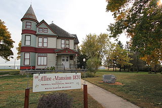
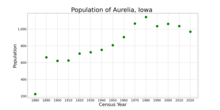
Newell is a city in Buena Vista County, Iowa, United States. The population was 906 according to the 2020 census.

<span class="mw-page-title-main">Alta Vista, Iowa</span> City in Iowa, United States

Alta Vista is a city in Chickasaw County, Iowa, United States. The population was 227 at the 2020 census.

<span class="mw-page-title-main">Vail, Iowa</span> City in Iowa, United States

Vail is a city in Crawford County, Iowa, United States. The population was 396 at the time of the 2020 census.

<span class="mw-page-title-main">De Soto, Iowa</span> City in Iowa, United States

De Soto is a city in Dallas County, Iowa, United States. The population was 915 at the time of the 2020 census. It is part of the Des Moines–West Des Moines Metropolitan Statistical Area.

<span class="mw-page-title-main">Mondamin, Iowa</span> City in Iowa, United States

Mondamin is a city in Harrison County, Iowa, United States. The population was 339 at the time of the 2020 census.

<span class="mw-page-title-main">Gilman, Iowa</span> City in Iowa, United States

Gilman is a city in the southeastern corner of Marshall County, Iowa, United States. The population was 542 at the time of the 2020 census.

<span class="mw-page-title-main">Emerson, Iowa</span> City in Iowa, United States

Emerson is a city in Mills County, Iowa, United States. The population was 403 at the time of the 2020 census.

<span class="mw-page-title-main">Pacific Junction, Iowa</span> City in Iowa, United States

Pacific Junction is a city in Mills County, Iowa, United States. The population was 96 at the time of the 2020 census.

<span class="mw-page-title-main">Carson, Iowa</span> City in Iowa, United States

Carson is a city in Pottawattamie County, Iowa, United States. The population was 766 at the 2020 census. Carson has a number of interesting and historic places.

<span class="mw-page-title-main">McClelland, Iowa</span> City in Iowa, United States

McClelland is a city in Pottawattamie County, Iowa, United States. The city was founded in 1903 after the Great Western Railroad was extended to include Council Bluffs, IA. The population was 146 at the time of the 2020 census.

<span class="mw-page-title-main">Neola, Iowa</span> City in Iowa, United States

Neola is a city in Pottawattamie County, Iowa, United States. The population was 918 at the time of the 2020 census.

<span class="mw-page-title-main">Conway, Iowa</span> City in Iowa, United States

Conway is a city in Taylor County, Iowa, United States. The population was 17 at the 2020 census.

<span class="mw-page-title-main">Alta Vista, Kansas</span> City in Wabaunsee County, Kansas

Alta Vista is a city in Wabaunsee County, Kansas, United States. As of the 2020 census, the population of the city was 409.

<span class="mw-page-title-main">Blairstown, Missouri</span> City in Missouri, United States

Blairstown is a city in Henry County, Missouri, United States. The population was 97 at the 2010 census.

<span class="mw-page-title-main">Terra Alta, West Virginia</span> Town in West Virginia, United States

Terra Alta is a town in eastern Preston County, West Virginia, United States. The population was 1,415 at the 2020 census. It is part of the Morgantown metropolitan area.

<span class="mw-page-title-main">West Bend, Iowa</span> City in Iowa, United States

West Bend is a city in Kossuth and Palo Alto (originally) counties in the U.S. state of Iowa. The population was 791 at the time of the 2020 census.

References

  1. "2020 U.S. Gazetteer Files". United States Census Bureau. Retrieved March 16, 2022.
  2. 1 2 "2020 Census State Redistricting Data". census.gov. United states Census Bureau. Retrieved August 12, 2021.
  3. "John Insley Blair Family Papers, 1843-1961 (Mostly 1891-1910) - Finding Aids".
  4. "US Gazetteer files: 2010, 2000, and 1990". United States Census Bureau. February 12, 2011. Retrieved April 23, 2011.
  5. "US Gazetteer files 2010". United States Census Bureau. Archived from the original on January 25, 2012. Retrieved May 11, 2012.
  6. "Census of Population and Housing". Census.gov. Retrieved June 4, 2015.
  7. "U.S. Census website". United States Census Bureau . Retrieved May 11, 2012.
  8. "U.S. Census website". United States Census Bureau . Retrieved January 31, 2008.
  9. "REORGANIZATION & DISSOLUTION ACTIONS SINCE 1965-66 Archived 2019-02-09 at the Wayback Machine ." Iowa Department of Education. Retrieved on July 29, 2018.