Balcones Heights, Texas

Last updated

Balcones Heights, Texas
Bhtxlogo.png
Bexar BalconesHeights.svg
Location of Balcones Heights, Texas
USA Texas location map.svg
Red pog.svg
Balcones Heights
Usa edcp location map.svg
Red pog.svg
Balcones Heights
North America laea location map.svg
Red pog.svg
Balcones Heights
Coordinates: 29°29′23″N98°32′53″W / 29.48972°N 98.54806°W / 29.48972; -98.54806
Country United States
State Texas
County Bexar
Government
  TypeType A general law
   City council Mayor Suzanne de Leon
Stephen Lara
Gloria Cantu
Juan Lecea
Lamar Gillian
Miguel Valverde [1]
  Interim city administratorGilbert T. Perales
Area
[2]
  Total0.66 sq mi (1.70 km2)
  Land0.66 sq mi (1.70 km2)
  Water0.00 sq mi (0.00 km2)
Elevation
[3]
833 ft (254 m)
Population
 (2020)
  Total2,746
  Density5,032.06/sq mi (1,944.32/km2)
Time zone UTC-6 (Central (CST))
  Summer (DST) UTC-5 (CDT)
ZIP code
78201
Area codes 210; 726 (assigned)
FIPS code 48-05384 [4]
GNIS feature ID1329967 [3]
Website bhtx.gov

Balcones Heights is a city in Bexar County, Texas, United States. Its population was 2,746 at the 2020 census, and it was incorporated in 1948. Balcones Heights is an enclave of San Antonio, surrounded entirely by the city, thus some residents and out-of-town visitors erroneously consider it merely a neighborhood of the larger city rather than its own unique community that did so to prevent annexation.

Contents

Geography

Balcones Heights is located at 29°29′23″N98°32′53″W / 29.48972°N 98.54806°W / 29.48972; -98.54806 (29.489729, –98.547927), [5] nine miles northwest of downtown San Antonio.

According to the United States Census Bureau, the city has a total area of 0.6 square miles (1.6 km2), all land.

Demographics

Balcones Heights racial composition as of 2020 [6]
(NH = Non-Hispanic) [lower-alpha 1]
RaceNumberPercentage
White (NH)41715.19%
Black or African American (NH)32311.76%
Native American or Alaska Native (NH)170.62%
Asian (NH)361.31%
Pacific Islander (NH)10.04%
Some other race (NH)130.47%
Mixed/multiracial (NH)501.82%
Hispanic or Latino 1,88968.79%
Total2,746

As of the 2020 United States census, 2,746 people, 1,461 households, and 558 families resided in the city.

Historical population
CensusPop.Note
1950 376
1960 950152.7%
1970 2,504163.6%
1980 2,6405.4%
1990 3,02214.5%
2000 3,016−0.2%
2010 2,941−2.5%
2020 2,746−6.6%
U.S. Decennial Census [8]

As of the census [4] of 2000, 3,016 people, 1,437 households, and 708 families lived in the city. The population density was 4,674.6 inhabitants per square mile (1,804.9/km2). The 1,539 housing units had an average density of 2,385.4 per square mile (921.0/km2). The racial makeup of the city was 69.66% White, 5.37% African American, 1.56% Native American, 1.13% Asian, 17.44% from other races, and 4.84% from two or more races. Hispanics or Latinos of any race were 69.60% of the population.

Of the 1,437 households, 27.2% had children under 18 living with them, 26.2% were married couples living together, 18.2% had a female householder with no husband present, and 50.7% were not families. About 43.6% of all households were made up of individuals, and 7.7% had someone living alone who was 65 or older. The average household size was 2.10, and the average family size was 2.92.

In the city, the age distribution was 23.7% under 18, 14.5% from 18 to 24, 33.1% from 25 to 44, 19.5% from 45 to 64, and 9.2% who were 65 or older. The median age was 32 years. For every 100 females, there were 107.1 males. For every 100 females 18 and over, there were 107.1 males.

The median income for a household in the city was $21,452, and for a family was $27,074. Males had a median income of $21,209 versus $18,944 for females. The per capita income for the city was $13,529. About 18.1% of families and 21.1% of the population were below the poverty line, including 23.6% of those under 18 and 15.2% of those 65 or over.

Education

Most of the city is served by San Antonio Independent School District. [9] Most residents of the San Antonio ISD section are zoned to Baskin Academy, [10] with a small portion zoned to Maverick Elementary. [11] All such residents are zoned to Longfellow Middle School, [12] and Jefferson High School, all in San Antonio. [13]

Some of the city is served by the North East Independent School District. [9] The portion is served by Dellview Elementary School, [14] Jackson Middle School, [15] and LEE High School, all in San Antonio. [16]

Related Research Articles

<span class="mw-page-title-main">Bexar County, Texas</span> County in Texas, United States

Bexar County is a county in the U.S. state of Texas. It is in South Texas and its county seat is San Antonio.

<span class="mw-page-title-main">Palos Heights, Illinois</span> City in Illinois, United States

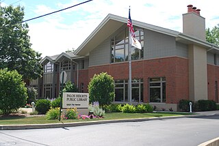
Palos Heights is a city in Cook County, Illinois, United States. It is a southwest suburb of Chicago. Per the 2020 census, the population was 12,068.

<span class="mw-page-title-main">Cross Mountain, Texas</span> Census-designated place in Texas, United States

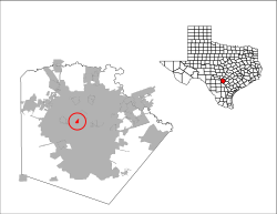
Cross Mountain is a census-designated place (CDP) in Bexar County, Texas, United States. The population was 3,944 at the 2020 census, an increase over the figure of 3,124 tabulated in 2010. It is part of the San Antonio Metropolitan Statistical Area.

<span class="mw-page-title-main">Grey Forest, Texas</span> City in Texas, United States

Grey Forest is a city in northwestern Bexar County, Texas, United States. The population was 492 at the 2020 census. It is part of the San Antonio Metropolitan Statistical Area.

<span class="mw-page-title-main">Leon Valley, Texas</span> City in Texas, United States

Leon Valley is a city in Bexar County, Texas, United States. It is an enclave on the northwestern side of San Antonio and is part of the San Antonio-New Braunfels metropolitan statistical area. Its population was 11,542 at the 2020 census. Leon Valley is an independent municipality surrounded by the city of San Antonio.

<span class="mw-page-title-main">Scenic Oaks, Texas</span> Census-designated place in Texas, United States

Scenic Oaks is a census-designated place (CDP) in Bexar County, Texas, United States. It is part of the San Antonio Metropolitan Statistical Area. The population was 10,458 at the 2010 census, up from 4,957 at the 2010 census.

<span class="mw-page-title-main">Shavano Park, Texas</span> City in Texas, United States

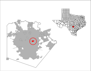
Shavano Park is a city located in Bexar County, Texas, United States. As of the 2020 census, the population was 3,524, an increase over the figure of 3,035 tabulated in 2010. It is part of the San Antonio Metropolitan Statistical Area, despite being much different in terms of demographics and having some of the wealthiest families in Bexar County.

<span class="mw-page-title-main">Terrell Hills, Texas</span> City in Texas, United States

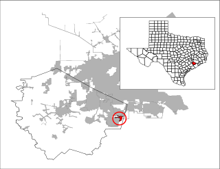
Terrell Hills is a city in Bexar County, Texas, United States; it is located 5 miles (8 km) northeast of downtown San Antonio. As of the 2020 census Terrell Hills had a population of 5,045. It is part of a group of three cities—Terrell Hills, Alamo Heights, and Olmos Park—located between Uptown San Antonio, Midtown San Antonio, Downtown San Antonio, and Fort Sam Houston. Terrell Hills is bordered on the west by Alamo Heights, on the east by Fort Sam Houston, on the north by Uptown San Antonio, and on the south by San Antonio's Near East Side. It is part of the San Antonio Metropolitan Statistical Area.

<span class="mw-page-title-main">Timberwood Park, Texas</span> Census-designated place in Texas, United States

Timberwood Park is a census-designated place (CDP) in far northern unincorporated Bexar County, Texas, United States and located within the southern edge of the Texas Hill Country. The district has roughly 42 miles of roads and encompasses over 2,000 acres. The overall plan shows 3,263 platted lots. The population was 35,217 at the 2020 census, up from 13,447 at the 2010 census. It is part of the San Antonio Metropolitan Statistical Area.

<span class="mw-page-title-main">Canyon Lake, Texas</span> CDP in Texas, United States

Canyon Lake is a census-designated place (CDP) in Comal County, Texas, United States. The population was 31,124 at the 2020 census. It is part of the San Antonio Metropolitan Statistical Area.

<span class="mw-page-title-main">Garden Ridge, Texas</span> City in Texas, United States

Garden Ridge is a city in Comal County, Texas, United States, incorporated in 1972. The population was 4,186 at the 2020 census, up from 3,259 at the 2010 census. It is part of the San Antonio metropolitan statistical rea.

<span class="mw-page-title-main">Arcola, Texas</span> City in Texas, United States

Arcola is a city in Fort Bend County, Texas, United States, within the Houston–Sugar Land–Baytown metropolitan area. The population was 2,034 as of the 2020 census, an increase over the figure of 1,642 tabulated by the 2010 census, which represented, in turn, an increase over the 2000 figure of 1,048.

<span class="mw-page-title-main">Taylor Lake Village, Texas</span> City in Harris County, Texas, United States

Taylor Lake Village is a city in Harris County, Texas, United States. The population was 3,704 at the 2020 U.S. census.

<span class="mw-page-title-main">Alamo, Texas</span> City in Texas

Alamo, located in the Rio Grande Valley in what is nicknamed the "Land of Two Summers", is a city in the irrigated area of southern Hidalgo County, Texas, United States. Known as the "Refuge to the Valley", it is located in an area of abundant vegetable farming and citrus groves, and is a noted winter resort/retirement town near the Mexico–U.S. border. Alamo is one of the Rio Grande Valley's gateways to Mexico, via U.S. Route 281 and Nuevo Progreso, Tamaulipas, as well as a gateway to the Santa Ana National Wildlife Refuge. Alamo's population was 18,353 at the 2010 census and an estimated 19,910 in 2019.

<span class="mw-page-title-main">Palmhurst, Texas</span> City in Texas

Palmhurst is a city in Hidalgo County, Texas, United States. The population was 2,607 at the 2010 United States Census. It is part of the McAllen–Edinburg–Mission and Reynosa–McAllen metropolitan areas.

<span class="mw-page-title-main">Linn, Texas</span> Census-designated place in Hidalgo County, Texas, United States

Linn, formerly San Manuel-Linn, is a census-designated place (CDP) in Hidalgo County, Texas, United States. The population was 801 at the 2010 census, down from 958 at the 2000 census. It is part of the McAllen–Edinburg–Mission Metropolitan Statistical Area.

<span class="mw-page-title-main">Porter Heights, Texas</span> Populated place in Texas, United States

Porter Heights is a census-designated place (CDP) in Montgomery County, Texas, United States. The population was 1,903 at the 2020 census.

<span class="mw-page-title-main">Escobares, Texas</span> City in Texas, United States

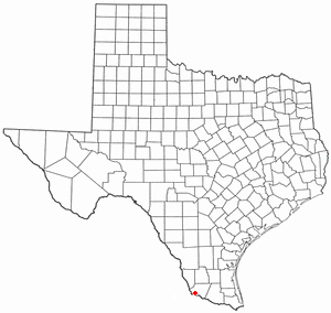
Escobares is a city in Starr County, Texas, United States. The population was 2,588 at the 2020 census. The city was formed in 2005 from part of the deleted Escobares CDP, and parts of Garceno, and North Escobares CDPs, and additional area. Prior to its 2005 incorporation as a city, it was a census-designated place (CDP). The population of the CDP was 1,954 at the 2000 census.

<span class="mw-page-title-main">Greater San Antonio</span> Metropolitan Statistical Area in Texas, United States

Greater San Antonio, officially designated San Antonio–New Braunfels, is an eight-county metropolitan area in the U.S. state of Texas defined by the Office of Management and Budget (OMB). The metropolitan area straddles South Texas and Central Texas and is on the southwestern corner of the Texas Triangle. The official 2020 U.S. census showed the metropolitan area's population at 2,558,143—up from a reported 1,711,103 in 2000—making it the 24th largest metropolitan area in the United States. Downtown Austin and Downtown San Antonio are approximately 80 miles (129 km) apart, and both fall along the Interstate 35 corridor. This combined metropolitan region of San Antonio–Austin has approximately 5 million people.

<span class="mw-page-title-main">Alamo Heights, Texas</span> City in Texas, United States

Alamo Heights is an incorporated city that is surrounded by the city of San Antonio in Bexar County in the U.S. state of Texas. At the time of the 2020 census, the population of Alamo Heights was 7,357. It is part of the Greater San Antonio metropolitan area. A portion of the University of the Incarnate Word is in Alamo Heights.

References

  1. "Mayor & City Council". City Of Balcones Heights. August 3, 2015. Retrieved May 4, 2020.
  2. "2019 U.S. Gazetteer Files". United States Census Bureau. Retrieved August 7, 2020.
  3. 1 2 U.S. Geological Survey Geographic Names Information System: Balcones Heights, Texas
  4. 1 2 "U.S. Census website". United States Census Bureau . Retrieved January 31, 2008.
  5. "US Gazetteer files: 2010, 2000, and 1990". United States Census Bureau. February 12, 2011. Retrieved April 23, 2011.
  6. "Explore Census Data". data.census.gov. Retrieved May 24, 2022.
  7. "About the Hispanic Population and its Origin". www.census.gov. Retrieved May 18, 2022.
  8. "Census of Population and Housing". Census.gov. Retrieved June 4, 2015.
  9. 1 2 "Zoning Map." City of Balcones Heights. Retrieved on March 24, 2010.
  10. "Baskin Elementary Attendance Boundary" (Archive). San Antonio Independent School District. Retrieved on June 26, 2016.
  11. "Maverick Elementary Attendance Boundary" (Archive). San Antonio Independent School District. Retrieved on June 26, 2016.
  12. "Longfellow Middle Attendance Boundary" (Archive). San Antonio Independent School District. Retrieved on June 26, 2016.
  13. "Jefferson High Attendance Boundary 2014-2015" (Archive). San Antonio Independent School District. Retrieved on June 26, 2016.
  14. "Dellview Elementary School [ permanent dead link ]" Map. North East Independent School District. Retrieved on March 24, 2010.
  15. "Jackson Middle School [ permanent dead link ]" Map. North East Independent School District. Retrieved on March 24, 2010.
  16. "Lee High School Archived 2010-08-06 at the Wayback Machine " Map. North East Independent School District. Retrieved on March 24, 2010.
  1. Note: the US Census treats Hispanic/Latino as an ethnic category. This table excludes Latinos from the racial categories and assigns them to a separate category. Hispanics/Latinos can be of any race. [7]