Grey Forest, Texas

Last updated

Grey Forest, Texas
TXMap-doton-GreyForest.PNG
Location of Grey Forest, Texas
Bexar GreyForest.svg
Coordinates: 29°37′1″N98°41′5″W / 29.61694°N 98.68472°W / 29.61694; -98.68472
Country United States
State Texas
County Bexar
Government
  MayorPaul Garro
Area
[1]
  Total0.71 sq mi (1.83 km2)
  Land0.70 sq mi (1.83 km2)
  Water0.00 sq mi (0.00 km2)
Elevation
[2]
1,142 ft (348 m)
Population
 (2020)
  Total492
  Density690/sq mi (270/km2)
Time zone UTC-6 (Central (CST))
  Summer (DST) UTC-5 (CDT)
ZIP code
78023
Area code(s) 210, 726 (planned)
FIPS code 48-31100 [3]
GNIS feature ID1337019 [2]
ANSI Code2410664 [4]
Website http://greyforest-tx.gov

Grey Forest is a city in northwestern Bexar County, Texas, United States. The population was 492 at the 2020 census. [5] It is part of the San Antonio Metropolitan Statistical Area.

Contents

Geography

Grey Forest is located on Scenic Loop Road, approximately 25 miles northwest of Downtown San Antonio.

According to the United States Census Bureau, the city has a total area of 0.7 square miles (1.8 km2), all land.

Demographics

Historical population
CensusPop.Note
1970 385
1980 44214.8%
1990 425−3.8%
2000 418−1.6%
2010 48315.6%
2020 4921.9%
U.S. Decennial Census [6]

As of the census [3] of 2000, there were 418 people, 179 households, and 127 families residing in the city. The population density was 565.9 inhabitants per square mile (218.5/km2). There were 211 housing units at an average density of 285.6 per square mile (110.3/km2). The racial makeup of the city was 98.80% White, 0.24% Native American, 0.72% from other races, and 0.24% from two or more races. Hispanic or Latino of any race were 7.66% of the population.

There were 179 households, out of which 28.5% had children under the age of 18 living with them, 59.2% were married couples living together, 8.9% had a female householder with no husband present, and 28.5% were non-families. 22.3% of all households were made up of individuals, and 6.1% had someone living alone who was 65 years of age or older. The average household size was 2.34 and the average family size was 2.75.

In the city, the population was spread out, with 19.9% under the age of 18, 5.7% from 18 to 24, 26.3% from 25 to 44, 33.5% from 45 to 64, and 14.6% who were 65 years of age or older. The median age was 44 years. For every 100 females, there were 95.3 males. For every 100 females age 18 and over, there were 91.4 males.

The median income for a household in the city was $47,614, and the median income for a family was $51,875. Males had a median income of $37,188 versus $29,464 for females. The per capita income for the city was $26,475. About 0.7% of families and 1.9% of the population were below the poverty line, including none of those under age 18 and 8.5% of those age 65 or over.

Education

Residents are zoned to schools in the Northside Independent School District. [7]

Students are zoned to:

Related Research Articles

<span class="mw-page-title-main">Bay County, Florida</span> County in Florida, United States

Bay County is a county on the Emerald Coast in Northwest Florida. As of the 2020 census, the population was 175,216. Its county seat is Panama City.

<span class="mw-page-title-main">Medina County, Texas</span> County in Texas, United States

Medina County is a county located in the U.S. state of Texas. As of the 2020 census, its population was 50,748. Its county seat is Hondo. The county is named for the Medina River. The extreme northern part of the county lies within the Edwards Plateau, which elevates into the Texas Hill Country. The Medina Dam, the fourth largest in the nation when completed in 1913, is listed on the National Register of Historic Places. The irrigation project, creating Medina Lake, was built by 1500 skilled workers who worked in shifts operating 24 hours a day to complete the dam in two years. Medina County is part of the San Antonio, TX Metropolitan Statistical Area.

<span class="mw-page-title-main">Bexar County, Texas</span> County in Texas, United States

Bexar County is a county in the U.S. state of Texas. It is in South Texas and its county seat is San Antonio.

<span class="mw-page-title-main">Gladstone, Missouri</span> City in Missouri, United States

Gladstone is a city in Clay County, Missouri, United States and a suburb of Kansas City. The City of Gladstone is located about 10–20 minutes from downtown Kansas City, and about 10–20 minutes from Kansas City International Airport. As of the 2020 census, the city population was 27,063. It is part of the Kansas City metropolitan area.

<span class="mw-page-title-main">Balcones Heights, Texas</span> City in Texas, United States

Balcones Heights is a city in Bexar County, Texas, United States. Its population was 2,746 at the 2020 census, and it was incorporated in 1948. Balcones Heights is an enclave of San Antonio, surrounded entirely by the city, thus some residents and out-of-town visitors erroneously consider it merely a neighborhood of the larger city rather than its own unique community that did so to prevent annexation.

<span class="mw-page-title-main">Cross Mountain, Texas</span> Census-designated place in Texas, United States

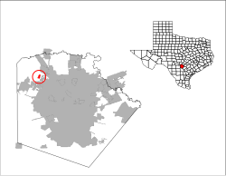
Cross Mountain is a census-designated place (CDP) in Bexar County, Texas, United States. The population was 3,944 at the 2020 census, an increase over the figure of 3,124 tabulated in 2010. It is part of the San Antonio Metropolitan Statistical Area.

<span class="mw-page-title-main">Helotes, Texas</span> City in Texas, United States

Helotes is a city in Bexar County, Texas, United States, located on the far northwestern side of San Antonio. It is part of the San Antonio-New Braunfels metropolitan statistical area. Its population was 9,030 at the 2020 census.

<span class="mw-page-title-main">Hill Country Village, Texas</span> City in Texas, United States

Hill Country Village is a city in Bexar County, Texas, United States. The population was 942 at the 2020 census. It is a very affluent enclave city, home to old money families. It is part of the San Antonio Metropolitan Statistical Area. It is the 7th wealthiest location in Texas by per capita income.

<span class="mw-page-title-main">Leon Valley, Texas</span> City in Texas, United States

Leon Valley is a city in Bexar County, Texas, United States. It is an enclave on the northwestern side of San Antonio and is part of the San Antonio-New Braunfels metropolitan statistical area. Its population was 11,542 at the 2020 census. Leon Valley is an independent municipality surrounded by the city of San Antonio.

<span class="mw-page-title-main">Scenic Oaks, Texas</span> Census-designated place in Texas, United States

Scenic Oaks is a census-designated place (CDP) in Bexar County, Texas, United States. It is part of the San Antonio Metropolitan Statistical Area. The population was 10,458 at the 2020 census, up from 4,957 at the 2010 census.

<span class="mw-page-title-main">Shavano Park, Texas</span> City in Texas, United States

Shavano Park is a city located in Bexar County, Texas, United States. As of the 2020 census, the population was 3,524, an increase over the figure of 3,035 tabulated in 2010. It is part of the San Antonio Metropolitan Statistical Area, despite being much different in terms of demographics and having some of the wealthiest families in Bexar County.

<span class="mw-page-title-main">Timberwood Park, Texas</span> Census-designated place in Texas, United States

Timberwood Park is a census-designated place (CDP) in far northern unincorporated Bexar County, Texas, United States and located within the southern edge of the Texas Hill Country. The district has roughly 42 miles of roads and encompasses over 2,000 acres. The overall plan shows 3,263 platted lots. The population was 35,217 at the 2020 census, up from 13,447 at the 2010 census. It is part of the San Antonio Metropolitan Statistical Area.

<span class="mw-page-title-main">Windcrest, Texas</span> City in Texas, United States

Windcrest is a city in Bexar County, Texas, United States. Its population was 5,865 at the 2020 census. It is part of the San Antonio metropolitan area.

<span class="mw-page-title-main">Wixon Valley, Texas</span> City in Texas, United States

Wixon Valley is a city in Brazos County, Texas, United States. The population was 228 at the 2020 census. It is part of the Bryan-College Station metropolitan area.

<span class="mw-page-title-main">Canyon Lake, Texas</span> CDP in Texas, United States

Canyon Lake is a census-designated place (CDP) in Comal County, Texas, United States. The population was 31,124 at the 2020 census. It is part of the San Antonio Metropolitan Statistical Area.

<span class="mw-page-title-main">Garden Ridge, Texas</span> City in Texas, United States

Garden Ridge is a city in Comal County, Texas, United States, incorporated in 1972. The population was 4,186 at the 2020 census, up from 3,259 at the 2010 census. It is part of the San Antonio metropolitan statistical rea.

<span class="mw-page-title-main">Pleak, Texas</span> Village in Texas, United States

Pleak is a village in Fort Bend County, Texas, United States, within the Houston–Sugar Land–Baytown metropolitan area. It is on Texas State Highway 36, south of Rosenberg. Its population was 971 at the 2020 census.

<span class="mw-page-title-main">Kingsbury, Texas</span> City in Texas, United States

Kingsbury is a city in eastern Guadalupe County, Texas, United States. Kingsbury was a Census-designated place in 2010, when the census reported a population of 782. It is part of the San Antonio Metropolitan Statistical Area. The election to incorporate Kingsbury into a Type-C Liberty City passed by a landslide vote of 66–2 on May 9, 2015 and the Order to declare Kingsbury a municipality was signed by County Judge Kyle Kutscher on May 19, 2015.

<span class="mw-page-title-main">Briarcliff, Texas</span> Village in Texas, United States

Briarcliff is a village in Travis County, Texas, United States. The population was 2,062 at the 2020 census.

<span class="mw-page-title-main">Creedmoor, Texas</span> City in Texas, United States

Creedmoor is a city in Travis County, Texas, United States. The population was 458 at the 2020 census.

References

  1. "2019 U.S. Gazetteer Files". United States Census Bureau. Retrieved August 7, 2020.
  2. 1 2 U.S. Geological Survey Geographic Names Information System: Grey Forest, Texas
  3. 1 2 "U.S. Census website". United States Census Bureau . Retrieved January 31, 2008.
  4. "US Gazetteer Files 2016-Places-Texas". US Census. Retrieved January 24, 2017.
  5. Bureau, US Census. "Search Results". The United States Census Bureau. Retrieved October 7, 2023.
  6. "Census of Population and Housing". Census.gov. Retrieved June 4, 2015.
  7. "2010 CENSUS - CENSUS BLOCK MAP: Grey Forest city, TX." U.S. Census Bureau. Retrieved on September 8, 2016.
  8. "2016-17 Elementary School Attendance Areas Archived 2016-09-08 at the Wayback Machine ." Northside Independent School District. Retrieved on September 8, 2016.
  9. "2016-17 Middle School Attendance Areas Archived 2016-09-08 at the Wayback Machine ." Northside Independent School District. Retrieved on September 8, 2016.
  10. "2016-17 High School Attendance Areas Archived 2016-09-08 at the Wayback Machine ." Northside Independent School District. Retrieved on September 8, 2016.