Olmos Park, Texas

Last updated

Olmos Park, Texas
Bexar OlmosPark.svg
Location of Olmos Park, Texas
Coordinates: 29°28′30″N98°29′17″W / 29.47500°N 98.48806°W / 29.47500; -98.48806
Country United States
State Texas
County Bexar
IncorporatedMay 1939 [1]
Government
  MayorDeanna Rickabaugh [2]
  City Council [2]
  • Will Brooks
  • Juliana Dusek
  • Erin Harrison
  • Kenyon McDonald
  • Sharon Plant
Area
[3]
  Total0.61 sq mi (1.59 km2)
  Land0.61 sq mi (1.59 km2)
  Water0.00 sq mi (0.00 km2)
Elevation
[4]
807 ft (246 m)
Population
 (2020)
  Total2,180
  Density3,600/sq mi (1,400/km2)
Time zone UTC-6 (Central (CST))
  Summer (DST) UTC-5 (CDT)
ZIP code
78212
Area code(s) 210, 726 (planned)
FIPS code 48-53988 [5]
GNIS feature ID1343270 [4]
ANSI Code2411315 [6]
Website http://www.olmospark.org/

Olmos Park is a city in Bexar County, Texas, United States. The population was 2,180 at the 2020 census. [7] The town is noted for its park-like setting, oak-tree lined streets, and large estates, many of which were constructed during the 1920s. [8] The town is four miles north of downtown San Antonio and is surrounded by the city of San Antonio on the west, north, and south side.

Contents

History

Olmos Park was developed in the 1920s as an exclusive suburb of San Antonio, which today completely surrounds it. H.C. Thorman, a renowned oilman and real estate tycoon, purchased property from an Austrian count and developed it into the posh Olmos Park. [9] The city occupied the site where Camp John Wise was built in 1917. Camp John Wise was a US Army balloonist training site. The camp shut down in 1919 when the balloonist training was moved to nearby Brooks Field.

Sometimes confused with the City of Olmos Park, Olmos Park Terrace, was developed by the same developer a few years later in the 1930s as part of his larger Olmos District development and borders Olmos Park's western edge. Olmos Park Terrace was designated a San Antonio Historic District on Oct. 4, 2007 by Ord. 2007-10-04-1070. [10] [11]

Geography

Olmos Park is located 4 miles north of Downtown San Antonio.

According to the United States Census Bureau, the city has a total area of 0.6-square-mile (1.6 km2), all land. It is an enclave of San Antonio, as it is completely bounded by the city. Olmos Park can be found in ZIP Code 78212.

U.S. Route 281 is a north-south highway that serves as the boundary for one side of the community, the other side being bounded by McCullough Road, a major San Antonio surface street.

Demographics

Historical population
CensusPop.Note
1940 1,822
1950 2,84155.9%
1960 2,457−13.5%
1970 2,250−8.4%
1980 2,069−8.0%
1990 2,1614.4%
2000 2,3438.4%
2010 2,237−4.5%
2020 2,180−2.5%
U.S. Decennial Census [12]

As of the census [5] of 2000, there were 2,343 people, 1,043 households, and 616 families residing in the city. The population density was 3,860.1 inhabitants per square mile (1,490.4/km2). There were 1,131 housing units at an average density of 1,863.3 per square mile (719.4/km2). The racial makeup of the city was 93.60% White, 2.09% African American, 0.47% Native American, 0.68% Asian, 0.09% Pacific Islander, 2.30% from other races, and 0.77% from two or more races. Hispanic or Latino of any race were 14.60% of the population.

There were 1,043 households, out of which 28.5% had children under the age of 18 living with them, 51.0% were married couples living together, 7.0% had a female householder with no husband present, and 40.9% were non-families. 36.1% of all households were made up of individuals, and 8.2% had someone living alone who was 65 years of age or older. The average household size was 2.24 and the average family size was 2.96.

In the city, the population was spread out, with 23.6% under the age of 18, 5.1% from 18 to 24, 28.1% from 25 to 44, 29.2% from 45 to 64, and 14.1% who were 65 years of age or older. The median age was 41 years. For every 100 females, there were 88.6 males. For every 100 females age 18 and over, there were 84.5 males.

The median income for a household in the city was $87,560, and the median income for a family was $128,814. Males had a median income of $81,296 versus $35,500 for females. The per capita income for the city was $65,697. About 1.9% of families and 3.9% of the population were below the poverty line, including 3.0% of those under age 18 and 2.1% of those age 65 or over. The median home price for 2019 was $756,000.

Government

Olmos Park adheres to the council-manager form of government. The mayor is Deanna Rickabaugh. [2]

Education

Most residents of Olmos Park are zoned to the Alamo Heights Independent School District, [13] and a small portion of Olmos Park is served by the San Antonio Independent School District.[ citation needed ]

Notable person

Related Research Articles

<span class="mw-page-title-main">Clinton Township, Butler County, Pennsylvania</span> Township in Pennsylvania, United States

Clinton Township is a township in Butler County, Pennsylvania, United States. The population was 2,913 at the 2020 census. For generations, it was home to a U.S. Steel plant.

<span class="mw-page-title-main">Millcreek Township, Lebanon County, Pennsylvania</span> Township in Pennsylvania, United States

Millcreek Township is a township in Lebanon County, Pennsylvania, United States. The population was 4,350 at the 2020 census. It is part of the Lebanon, Pennsylvania Metropolitan Statistical Area.

<span class="mw-page-title-main">Jourdanton, Texas</span> City in Texas, United States

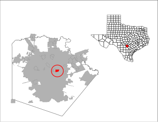
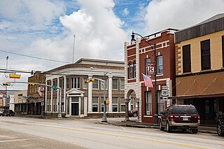
Jourdanton is a city in and the county seat of Atascosa County, Texas, United States. The population is 4,094. It is part of the San Antonio metropolitan statistical area. The mayor is Robert "Doc" Williams. The city manager is Bobby J. Martinez. The police chief is Eric Kaiser. The fire chief is Jay Fojtik.

<span class="mw-page-title-main">Lakehills, Texas</span> CDP in Texas, United States

Lakehills is a census-designated place (CDP) in Bandera County, Texas, United States. The population was 5,150 at the 2010 census, making it the most populous place in Bandera County. It is part of the San Antonio Metropolitan Statistical Area.

<span class="mw-page-title-main">Converse, Texas</span> City in Texas, United States

Converse is a city in Bexar County, Texas, United States, 15 miles (24 km) northeast of downtown San Antonio. As of the 2020 census, it had a population of 27,466. It is part of the San Antonio Metropolitan Statistical Area.

<span class="mw-page-title-main">Grey Forest, Texas</span> City in Texas, United States

Grey Forest is a city in northwestern Bexar County, Texas, United States. The population was 492 at the 2020 census. It is part of the San Antonio Metropolitan Statistical Area.

<span class="mw-page-title-main">Hill Country Village, Texas</span> City in Texas, United States

Hill Country Village is a city in Bexar County, Texas, United States. The population was 942 at the 2020 census. It is a very affluent enclave city, home to old money families. It is part of the San Antonio Metropolitan Statistical Area. It is the 7th wealthiest location in Texas by per capita income.

<span class="mw-page-title-main">Kirby, Texas</span> City in Texas, United States

Kirby is a city in Bexar County, Texas, United States. According to the 2020 United States Census, there were 8,142 people in the city.It is an enclave of San Antonio and is part of the San Antonio metropolitan statistical area. Founded as an agricultural settlement along the Southern Pacific railroad, the city was transformed into a suburban community upon its incorporation in 1955. It is known as the "Hobo Capital of Texas."

<span class="mw-page-title-main">Leon Valley, Texas</span> City in Texas, United States

Leon Valley is a city in Bexar County, Texas, United States. It is an enclave on the northwestern side of San Antonio and is part of the San Antonio-New Braunfels metropolitan statistical area. Its population was 11,542 at the 2020 census. Leon Valley is an independent municipality surrounded by the city of San Antonio.

<span class="mw-page-title-main">Scenic Oaks, Texas</span> Census-designated place in Texas, United States

Scenic Oaks is a census-designated place (CDP) in Bexar County, Texas, United States. It is part of the San Antonio Metropolitan Statistical Area. The population was 10,458 at the 2020 census, up from 4,957 at the 2010 census.

<span class="mw-page-title-main">Shavano Park, Texas</span> City in Texas, United States

Shavano Park is a city located in Bexar County, Texas, United States. As of the 2020 census, the population was 3,524, an increase over the figure of 3,035 tabulated in 2010. It is part of the San Antonio Metropolitan Statistical Area, despite being much different in terms of demographics and having some of the wealthiest families in Bexar County.

<span class="mw-page-title-main">Terrell Hills, Texas</span> City in Texas, United States

Terrell Hills is a city in Bexar County, Texas, United States; it is located 5 miles (8 km) northeast of downtown San Antonio. As of the 2020 census Terrell Hills had a population of 5,045. It is part of a group of three cities—Terrell Hills, Alamo Heights, and Olmos Park—located between Uptown San Antonio, Midtown San Antonio, Downtown San Antonio, and Fort Sam Houston. Terrell Hills is bordered on the west by Alamo Heights, on the east by Fort Sam Houston, on the north by Uptown San Antonio, and on the south by San Antonio's Near East Side. It is part of the San Antonio Metropolitan Statistical Area.

<span class="mw-page-title-main">Windcrest, Texas</span> City in Texas, United States

Windcrest is a city in Bexar County, Texas, United States. Its population was 5,865 at the 2020 census. It is part of the San Antonio metropolitan area.

<span class="mw-page-title-main">Marion, Texas</span> City in Texas, United States

Marion is a city in Guadalupe County, Texas, United States. The town was incorporated by 1941. The population was 1,034 at the 2020 census. It is part of the San Antonio Metropolitan Statistical Area.

<span class="mw-page-title-main">Santa Clara, Texas</span> City in Texas, United States

Santa Clara is a city in Guadalupe County, Texas, United States. The population was 725 at the 2010 census, down from 889 at the 2000 census. It is part of the San Antonio Metropolitan Statistical Area.

<span class="mw-page-title-main">Kenedy, Texas</span> City in Texas, United States

Kenedy is a city in Karnes County, Texas, United States, named for Mifflin Kenedy, who bought 400,000 acres (1,600 km2) and wanted to develop a new town that would carry his name. The population was 3,473 at the 2020 census, up from 3,296 at the 2010 census.

<span class="mw-page-title-main">Devine, Texas</span> City in Texas, United States

Devine is a city in Medina County, Texas, United States. The population was 4,324 at the 2020 census. It is part of the San Antonio Metropolitan Statistical Area.

<span class="mw-page-title-main">Natalia, Texas</span> City in Texas, United States

Natalia is a city in Medina County, Texas, United States. The population was 1,202 at the 2020 census. It was founded in 1912 and was named after Natalie Pearson Nicholson, daughter of Frederick Stark Pearson, engineer, designer and builder of the Medina Dam.

<span class="mw-page-title-main">Selma, Texas</span> City in Texas, United States

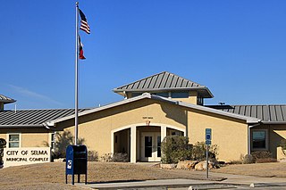
Selma is a city in Bexar, Comal, and Guadalupe counties in the U.S. state of Texas. It is part of the San Antonio metropolitan statistical area. Its population was 10,952 at the 2020 census, up from 5,540 at the 2010 census. Selma was settled by German and Polish immigrants in the mid 1800s.

<span class="mw-page-title-main">Alamo Heights, Texas</span> City in Texas, United States

Alamo Heights is an incorporated city that is surrounded by the city of San Antonio in Bexar County in the U.S. state of Texas. At the time of the 2020 census, the population of Alamo Heights was 7,357. It is part of the Greater San Antonio metropolitan area. A portion of the University of the Incarnate Word is in Alamo Heights.

References

  1. http://olmospark.org/vertical/sites/%7BC363F155-8965-4219-9F03-A72E929D1E68%7D/uploads/12financialreport.pdf [ bare URL PDF ]
  2. 1 2 3 "Olmos Park City Mayor and Council". City of Olmos Park. Retrieved November 12, 2022.
  3. "2019 U.S. Gazetteer Files". United States Census Bureau. Retrieved August 7, 2020.
  4. 1 2 U.S. Geological Survey Geographic Names Information System: Olmos Park, Texas
  5. 1 2 "U.S. Census website". United States Census Bureau . Retrieved January 31, 2008.
  6. "US Gazetteer Files 2016-Places-Texas". US Census. Retrieved January 24, 2017.
  7. Bureau, US Census. "Search Results". The United States Census Bureau. Retrieved October 7, 2023.
  8. Yves Gerem (2001). A Marmac Guide to San Antonio. Pelican Publishing. p. 38. ISBN   978-1-4556-0854-6.
  9. "About Olmos Park".
  10. City of San Antonio Website
  11. "Olmos Park Terrace Neighborhood". Archived from the original on July 27, 2011. Retrieved August 27, 2009.
  12. "Census of Population and Housing". Census.gov. Retrieved June 4, 2015.
  13. "Olmos Park city, Texas Archived 2011-06-06 at the Wayback Machine ." U.S. Census Bureau. Retrieved on March 24, 2010.