Castroville, Texas

Last updated

Castroville, Texas
Castroville City Hall Wiki.jpg
Castroville City Hall
City of Castroville Texas Seal.gif
Nickname: 
The Little Alsace of Texas
TXMap-doton-Castroville.PNG
Location of Castroville, Texas
Medina County Castroville.svg
Coordinates: 29°21′N98°53′W / 29.350°N 98.883°W / 29.350; -98.883
Country United States
State Texas
County Medina
IncorporatedJanuary 16, 1850 [1]
Government
  Type Council-Manager
   City Council Mayor J Darrin Schroeder
   City Manager R Scott Dixon
Area
[2]
  Total2.91 sq mi (7.55 km2)
  Land2.88 sq mi (7.46 km2)
  Water0.03 sq mi (0.09 km2)
Elevation
[3]
758 ft (231 m)
Population
 (2020)
  Total2,954
  Density1,000/sq mi (390/km2)
Time zone UTC-6 (Central (CST))
  Summer (DST) UTC-5 (CDT)
ZIP codes
78009, 78023
Area code 830
FIPS code 48-13312 [4]
GNIS feature ID1353948 [3]
Website www.castrovilletx.gov

Castroville is a city in Medina County, Texas, United States. Its population was 2,954 at the 2020 census. [5] Prior to 1893, Castroville was the first county seat of Medina County. Castroville was founded by Alsatian-Texans, who came to Texas during the German emigration period of the mid-1800s. Most Alsatians who came to Castroville spoke Alsatian (a dialect of German origin integrating Celtic, Yiddish, and French words). The Alsatian culture and language are still kept alive by the residents of Castroville. [6]

Contents

History

Castroville was established in 1844 by Henri Castro, an empresario of the Republic of Texas, who brought several dozen European families to the area from Alsace and adjoining Baden to populate his land grant along the Medina River 20 miles (32 km) west of San Antonio. The first colonists disembarked at Galveston on January 9, 1843. They were taken by ship to Lavaca Bay and traveled overland to San Antonio, where they took shelter in abandoned buildings until the Texas Rangers were prepared to escort them to their land and protect them from hostile Indians. On September 2, 1844, the first colonists arrived at Castro's land grant on the Medina River. [7]

From 1849, Castroville, on the Medina River, was a water stop on the San Antonio-El Paso Road and a stagecoach station on the San Antonio-El Paso Mail Line and San Antonio-San Diego Mail Line.

After a few hard years, the town and surrounding farms flourished, but for generations, the residents remained insular. In Castroville's first century, a visitor would be more likely to hear Alsatian—a dialect spoken in Europe before Standard German was prevalent—than English spoken in the town's homes, stores, and taverns. Modern Alsatian travelers noted that the dialect spoken in Castroville was more like that which was spoken in the 1840s. The descendants of the original settlers worked diligently to preserve their language, whose usage in Europe has been diminished by the political actions of France and Germany, especially since World War II.

The Steinbach Haus (originally built between 1618 and 1648 in Wahlbach, Alsace) was dismantled and reconstructed in Castroville in 1998. It was opened to the public in 2002.

Sister cities

Castroville has two twin towns:

Geography

Castroville is located at 29°21′N98°53′W / 29.350°N 98.883°W / 29.350; -98.883 (29.3550, −98.8807). [8] This is 26 miles west of downtown San Antonio.

According to the United States Census Bureau, the city has a total area of 2.5 square miles (6.5 km2), of which 0.39% is covered with water.

Demographics

Historical population
CensusPop.Note
1850 366
1860 45825.1%
1870 51512.4%
1880 73141.9%
1890 679−7.1%
1950 985
1960 1,50853.1%
1970 1,89325.5%
1980 1,821−3.8%
1990 2,15918.6%
2000 2,66423.4%
2010 2,6800.6%
2020 2,95410.2%
U.S. Decennial Census [9]

2020 census

Castroville racial composition [10]
(NH = Non-Hispanic) [lower-alpha 1]
RaceNumberPercentage
White (NH)1,62054.84%
Black or African American (NH)210.71%
Native American or Alaska Native (NH)80.27%
Asian (NH)190.64%
Pacific Islander (NH)10.03%
Some other race (NH)100.34%
Mixed/multiracial (NH)471.59
Hispanic or Latino 1,22841.57%
Total2,954

As of the 2020 United States census, there were 2,954 people, 1,113 households, and 860 families residing in the city.

2010 census

As of the census [4] of 2010, 3,053 people resided in the city. The population density was 1,045.4 inhabitants per square mile (403.6/km2). The 1,025 housing units had an average density of 402.2 per square mile (155.3/km2). [12]

Of the 941 households, 37.4% had children under 18 living with them, 61.5% were married couples living together, 10.4% had a female householder with no husband present, and 23.5% were not families. About 20.5% of all households were made up of individuals, and 8.7% had someone living alone who was 65 or older. The average household size was 2.74, and the average family size was 3.17.

In the city, the population was distributed as 28.0% under 18, 6.9% from 18 to 24, 27.7% from 25 to 44, 21.7% from 45 to 64, and 15.6% who were 65 or older. The median age was 37 years. For every 100 females, there were 97.2 males. For every 100 females age 18 and over, there were 88.3 males.

The median income for a household in the city was $42,308, and for a family was $51,007. Males had a median income of $35,625 versus $27,228 for females. The per capita income for the city was $20,615. About 5.4% of families and 9.1% of the population were below the poverty line, including 11.9% of those under age 18 and 5.9% of those age 65 or over.

Education

The City of Castroville is served by the Medina Valley Independent School District and Saint Louis Catholic School (Pre-kindergarten–5th grade).

Related Research Articles

<span class="mw-page-title-main">Alsace</span> Region of France

Alsace is a cultural region and a territorial collectivity in eastern France, on the west bank of the upper Rhine next to Germany and Switzerland. In January 2021, it had a population of 1,919,745. Alsatian culture is characterized by a blend of German and French influences.

<span class="mw-page-title-main">Medina County, Texas</span> County in Texas, United States

Medina County is a county located in the U.S. state of Texas. As of the 2020 census, its population was 50,748. Its county seat is Hondo. The county is named for the Medina River. The extreme northern part of the county lies within the Edwards Plateau, which elevates into the Texas Hill Country. The Medina Dam, the fourth largest in the nation when completed in 1913, is listed on the National Register of Historic Places. The irrigation project, creating Medina Lake, was built by 1500 skilled workers who worked in shifts operating 24 hours a day to complete the dam in two years. Medina County is part of the San Antonio, TX Metropolitan Statistical Area.

<span class="mw-page-title-main">Calhoun County, Texas</span> County in Texas, United States

Calhoun County is a county located in the U.S. state of Texas. As of the 2020 census, the population was 20,106. Its county seat is Port Lavaca. The county is named for John Caldwell Calhoun, the seventh vice president of the United States. Calhoun County comprises the Port Lavaca, TX Micropolitan Statistical Area, which is also included in the Victoria-Port Lavaca, TX Combined Statistical Area.

<span class="mw-page-title-main">Bexar County, Texas</span> County in Texas, United States

Bexar County is a county in the U.S. state of Texas. It is in South Texas and its county seat is San Antonio.

<span class="mw-page-title-main">Castroville, California</span> Unincorporated community in California, United States

Castroville is an unincorporated town and census-designated place (CDP) in Monterey County, California, United States. At the time of the 2020 census the population was 7,515, up from 6,481 in 2010. Castroville is known for its artichoke crop and for the annual Castroville Artichoke Festival, leading to its nickname as the "Artichoke Center of the World".

<span class="mw-page-title-main">Lakehills, Texas</span> CDP in Texas, United States

Lakehills is a census-designated place (CDP) in Bandera County, Texas, United States. The population was 5,295 at the 2020 census, making it the most populous place in Bandera County. It is part of the San Antonio Metropolitan Statistical Area.

<span class="mw-page-title-main">Hill Country Village, Texas</span> City in Texas, United States

Hill Country Village is a city in Bexar County, Texas, United States. The population was 942 at the 2020 census. It is a very affluent enclave city, home to old money families. It is part of the San Antonio Metropolitan Statistical Area. It is the 7th wealthiest location in Texas by per capita income.

<span class="mw-page-title-main">Kirby, Texas</span> City in Texas, United States

Kirby is a city in Bexar County, Texas, United States. According to the 2020 United States Census, there were 8,142 people in the city. It is an enclave of San Antonio and is part of the San Antonio metropolitan statistical area. Founded as an agricultural settlement along the Southern Pacific railroad, the city was transformed into a suburban community upon its incorporation in 1955. It is known as the "Hobo Capital of Texas."

<span class="mw-page-title-main">George West, Texas</span> City in Texas, United States

George West is a city in Live Oak County, Texas, United States, and named for cattle rancher George Washington West. The population was 2,445 at the 2010 census. It is the county seat of Live Oak County. George West was named the "storytelling capital of Texas" in 2005 by the Texas Senate; and it hosts the George West Storyfest, a festival that features storytelling, cowboy poetry, and music. Numerous ranches surround George West.

<span class="mw-page-title-main">Devine, Texas</span> City in Texas, United States

Devine is a city in Medina County, Texas, United States. The population was 4,324 at the 2020 census. It is part of the San Antonio Metropolitan Statistical Area.

<span class="mw-page-title-main">Hondo, Texas</span> City in Texas, United States

Hondo is a city in and the county seat of Medina County, Texas, United States. According to the 2020 Census, the population was 8,289. It is part of the San Antonio Metropolitan Statistical Area.

<span class="mw-page-title-main">LaCoste, Texas</span> City in Texas, United States

La Coste is a city in Medina County, Texas, United States. The population was 1,077 at the 2010 census. It is part of the San Antonio Metropolitan Statistical Area.

<span class="mw-page-title-main">Natalia, Texas</span> City in Texas, United States

Natalia is a city in Medina County, Texas, United States. The population was 1,202 at the 2020 census. It was founded in 1912 and was named after Natalie Pearson Nicholson, daughter of Frederick Stark Pearson, engineer, designer and builder of the Medina Dam.

<span class="mw-page-title-main">Utopia, Texas</span> Census-designated place in Texas, United States

Utopia is a census-designated place (CDP) in Uvalde County, Texas, United States. The population was 227 at the 2010 census.

<span class="mw-page-title-main">Henri Castro</span> American diplomat (1786–1865)

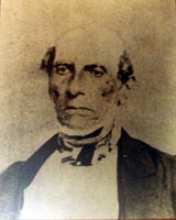
Henri Castro, a Jewish Texan, was one of the most important empresarios of the Republic of Texas.

Rio Medina or Riomedina is an unincorporated community in Medina County, Texas, United States. It is located approximately six miles north of Castroville and is part of the San Antonio Metropolitan Statistical Area. According to the 2006–07 Texas Almanac, it had a population of 60 people in 2000. According to an online community profile, Rio Medina has a population of 541 people.

<span class="mw-page-title-main">Greater San Antonio</span> Metropolitan Statistical Area in Texas, United States

Greater San Antonio, officially designated San Antonio–New Braunfels, is an eight-county metropolitan area in the U.S. state of Texas defined by the Office of Management and Budget (OMB). The metropolitan area straddles South Texas and Central Texas and is on the southwestern corner of the Texas Triangle. The official 2020 U.S. census showed the metropolitan area's population at 2,558,143—up from a reported 1,711,103 in 2000—making it the 24th largest metropolitan area in the United States. Downtown Austin and Downtown San Antonio are approximately 80 miles (129 km) apart, and both fall along the Interstate 35 corridor. This combined metropolitan region of San Antonio–Austin has approximately 5 million people.

<span class="mw-page-title-main">Landmark Inn State Historic Site</span> United States historic place

The Landmark Inn State Historic Site is a historic inn in Castroville, Texas, United States. It serves the general public as both a state historic site and a bed & breakfast with eight overnight rooms.

<span class="mw-page-title-main">New Fountain, Texas</span> Ghost town in Texas, United States

New Fountain is a ghost town established in 1846. It is located 1.8 miles (2.9 km) west of Quihi and 5.6 miles (9.0 km) east northeast of Hondo in Medina County in the U.S. state of Texas. It was part of empresario Henri Castro's colonization of the Medina River valley in the Republic of Texas.

<span class="mw-page-title-main">Castroville Historic District</span> Historic core of Castroville, Texas

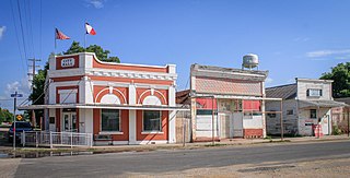
Castroville Historic District is a United States historic district in Castroville, Texas. It includes the oldest parts of the city of Castroville and contains twelve designated contributing properties, including a Texas State Historic Site and numerous Recorded Texas Historic Landmarks. The district was listed on the National Register of Historic Places in 1970.

References

  1. Texas (1898). "The Laws of Texas 1822–1897: Austin's Colonization Law and Contract; Mexican Constitution of 1824; Federal Colonization Law; Colonization Laws of Coahuila and Texas; Colonization Law of State of Tamaulipas; Fredonian Declaration of Independence; Laws and Decrees, with Constitution of Coahuila and Texas; San Felipe Convention; Journals of the Consultation; Proceedings of the General Council; Goliad Declaration of Independence; Journals of the Convention at Washington; Ordinances and Decrees of the Consultation; Declaration of Independence; Constitution of the Republic; Laws, General and Special, of the Republic; Annexation Resolution of the United States; Ratification of the Same by Texas; Constitution of the United States; Constitutions of the State of Texas, with All the Laws, General and Special, Passed Thereunder, Including Ordinances, Decrees, and Resolutions, with the Constitution of the Confederate States and the Reconstruction Acts of Congress".
  2. "2019 U.S. Gazetteer Files". United States Census Bureau. Retrieved August 7, 2020.
  3. 1 2 U.S. Geological Survey Geographic Names Information System: Castroville, Texas
  4. 1 2 "U.S. Census website". United States Census Bureau . Retrieved January 31, 2008.
  5. "Explore Census Data". data.census.gov. Retrieved April 30, 2024.
  6. "Alsatian Language – Castroville Area Chamber of Commerce". September 21, 2017.
  7. Wolff, Linda (1999). Indianola and Matagorda Island 1837 – 1887. Austin, Texas: Eakin Press. p. 9. ISBN   1-57168-340-2.
  8. "US Gazetteer files: 2010, 2000, and 1990". United States Census Bureau. February 12, 2011. Retrieved April 23, 2011.
  9. "Census of Population and Housing". Census.gov. Retrieved June 4, 2015.
  10. "Explore Census Data". data.census.gov. Retrieved May 20, 2022.
  11. "About the Hispanic Population and its Origin". www.census.gov. Retrieved May 18, 2022.
  12. "Archived copy" (PDF). Archived from the original (PDF) on March 15, 2006. Retrieved August 4, 2006.{{cite web}}: CS1 maint: archived copy as title (link)
  1. Note: the US Census treats Hispanic/Latino as an ethnic category. This table excludes Latinos from the racial categories and assigns them to a separate category. Hispanics/Latinos can be of any race. [11]