
The Robert F. Kennedy Bridge is a complex of bridges and elevated expressway viaducts in New York City. The bridges link the boroughs of Manhattan, Queens, and the Bronx. The viaducts cross Randalls and Wards Islands, previously two islands and now joined by landfill.
Hunts Point is a neighborhood located on a peninsula in the South Bronx of New York City. It is the location of one of the largest food distribution facilities in the world, the Hunts Point Cooperative Market. Its boundaries are the Bruckner Expressway to the west and north, the Bronx River to the east, and the East River to the south. Hunts Point Avenue is the primary street through Hunts Point.

Hart Island, sometimes referred to as Hart's Island, is located at the western end of Long Island Sound, in the northeastern Bronx in New York City. Measuring approximately 1 mile (1.6 km) long by 0.33 miles (0.53 km) wide, Hart Island is part of the Pelham Islands archipelago, to the east of City Island.

Bronx Park is a public park along the Bronx River, in the Bronx, New York City. The park is bounded by Southern Boulevard to the southwest, Webster Avenue to the northwest, Gun Hill Road to the north, Bronx Park East to the east, and East 180th Street to the south. With an area of 718 acres (2.91 km2), Bronx Park is the eighth-largest park in New York City.

Fort Washington Park is a public park located in the Washington Heights section of Upper Manhattan in New York City. It runs along the banks of the Hudson River next to Riverside Drive and the Henry Hudson Parkway from West 155th Street to Dyckman Street. The George Washington Bridge crosses above the park; below the bridge is a small point of land called Jeffrey's Hook, which is the site of the Little Red Lighthouse.

Crotona Park is a public park in the South Bronx in New York City, covering 127.5 acres (51.6 ha). The park is bounded by streets of the same name on its northern, eastern, southern, and western borders, and is adjacent to the Crotona Park East and Morrisania neighborhoods of the Bronx. It is divided into four portions by Claremont Parkway and Crotona Avenue, which run through it.
Westchester Creek is a tidal inlet of the East River located in the south eastern portion of the Bronx in New York City. It is 2.1 miles (3.39 km) in length. The creek formerly traveled further inland, to what is now Pelham Parkway, extending almost to Eastchester Bay and making Throggs Neck into an island during heavy storms. However, much of the route has been filled in, replaced by such structures as the New York City Subway's Westchester Yard and the Hutchinson Metro Center. Westchester Creek's present-day head is at Herbert H. Lehman High School; the remaining portion is largely inaccessible and surrounded by industrial enterprises or empty lots. Westchester Creek is traversed by the Bruckner Interchange at about its midpoint.

The Riegelmann Boardwalk is a 2.7-mile-long (4.3 km) boardwalk along the southern shore of the Coney Island peninsula in the New York City borough of Brooklyn, facing the Atlantic Ocean. Opened in 1923, the boardwalk runs between West 37th Street at the edge of the Sea Gate neighborhood to the west and Brighton 15th Street in Brighton Beach to the east. It is operated by the New York City Department of Parks and Recreation.

Starlight Park is a public park located along the Bronx River in the Bronx in New York City. Starlight Park stands on the site of an amusement park of the same name that operated in the first half of the 20th century.

Playground 52 is a 1.8-acre (0.73 ha) playground at 681 Kelly Street in the Longwood neighborhood of the Bronx, in New York City. The playground features basketball and handball courts, bathrooms, a spray shower, and a skate park. as well as an amphitheater with a large dance floor.

The Municipal Asphalt Plant is a former asphalt plant at York Avenue and 91st Street on the Upper East Side of Manhattan in New York City, housing the Asphalt Green recreation center. The asphalt plant was completed in 1944 to designs by Ely Jacques Kahn and Robert Allan Jacobs. The current structure, originally a mixing plant, reopened as the George and Annette Murphy Center in 1984; it was attached to a conveyor belt and storage facility, both of which have been demolished. The Murphy Center is a New York City designated landmark and is listed on the National Register of Historic Places.

The Battery, formerly known as Battery Park, is a 25-acre (10 ha) public park located at the southern tip of Manhattan Island in New York City facing New York Harbor. It is bounded by Battery Place on the north, State Street on the east, New York Harbor to the south, and the Hudson River to the west. The park contains attractions such as an early 19th-century fort named Castle Clinton; multiple monuments; and the SeaGlass Carousel. The surrounding area, known as South Ferry, contains multiple ferry terminals, including the Staten Island Ferry's Whitehall Terminal; a boat launch to the Statue of Liberty National Monument ; and a boat launch to Governors Island.
St. Mary's Park is a public park in the Mott Haven neighborhood in the South Bronx section of the Bronx, New York City. The park has sporting facilities and an indoor recreation center.

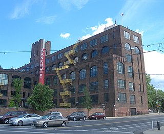
The American Bank Note Company Printing Plant is a repurposed printing plant in the Hunts Point neighborhood of the Bronx in New York City. It was built in 1909 by the American Bank Note Company, contemporaneously with their corporate headquarters in Manhattan. In addition to printing paper documents, stamps, and currency, the plant also minted coins, and was thus known by local area residents as The Penny Factory.

The South Bronx Greenway is a project to improve waterfront access, recreational facilities, and transportation systems, including pedestrian and bicycle paths, in the South Bronx in New York City.

Sunset Park is a 24.5-acre (9.9 ha) public park in the neighborhood of Sunset Park, Brooklyn, New York City, between 41st and 44th Streets and 5th and 7th Avenues. The modern-day park contains a playground, recreation center, and pool. The recreation center and pool comprise the Sunset Play Center, which was designated as both an exterior and interior landmark by the New York City Landmarks Preservation Commission. The park is operated by the New York City Department of Parks and Recreation, also known as NYC Parks.

Calvert Vaux Park is an 85.53-acre (34.61 ha) public park in Gravesend, Brooklyn, in New York City. Created in 1934, it is composed of several disconnected sections along the Belt Parkway between Bay 44th and Bay 49th Streets. The peninsula upon which the park is located faces southwest into Gravesend Bay, immediately north of the Coney Island Creek. The park was expanded in the 1960s by waste from the construction of the Verrazzano-Narrows Bridge, and was renamed after architect Calvert Vaux in 1998. It is operated by the New York City Department of Parks and Recreation, also known as NYC Parks.
Rocking the Boat is a non-profit organization in The Bronx, New York City. They run educational programs for high school students, teaching boat building, environmental science, and sailing, with the goal of empowering economically disadvantaged young people in the South Bronx. An annual fund-raising event features rowing around Manhattan.

Little Island at Pier 55 is an artificial island park in the Hudson River west of Manhattan in New York City, adjoining Hudson River Park. Designed by Heatherwick Studio, it is near the intersection of West Street and 13th Street in the Meatpacking District and Chelsea neighborhoods of Manhattan. It is located slightly west of the Manhattan shoreline atop Hudson River Pier 55, connected to Hudson River Park in Manhattan by footbridges at 13th and 14th Streets.

Claremont Park is a park in the Morrisania section of the Bronx in New York City. The land on which the park sits was once part of the Morris family estate. It became a municipal park in 1884 as part of the New Parks Act.
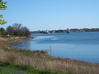
 Barretto Point Park from Tiffany Street Pier
 Tiffany Street Pier near Barretto Point Park, with North Brother and South Brother islands in the distance
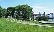 Amphitheater
 Amphitheater
 Floating Pool Lady
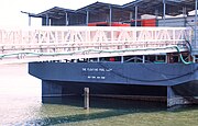 Floating Pool Lady


