
Briarwood is a middle-class neighborhood in the New York City borough of Queens. The neighborhood is roughly bounded by the Van Wyck Expressway to the west, Parsons Boulevard to the east, Union Turnpike to the north, and Hillside Avenue to the south.

Douglaston–Little Neck is a neighborhood in the northeastern part of the New York City borough of Queens. The community is located on the North Shore of Long Island, bordered to the east by the region of Great Neck in Nassau County, to the south by Glen Oaks and the North Shore Towers, and to the west by Bayside.

Interstate 495 (I-495), commonly known as the Long Island Expressway (LIE), is an auxiliary Interstate Highway in southeastern New York state. It is jointly maintained by the New York State Department of Transportation (NYSDOT), the New York City Department of Transportation (NYCDOT), MTA Bridges and Tunnels (TBTA), and the Port Authority of New York and New Jersey (PANYNJ).

The Cross Island Parkway is a controlled-access parkway in New York City, part of the Belt System of parkways running along the perimeter of the boroughs of Queens and Brooklyn. The Cross Island Parkway runs 10.6 miles (17.1 km) from the Whitestone Expressway in Whitestone past the Throgs Neck Bridge, along and across the border of Queens and Nassau County to meet up with the Southern State Parkway, acting as a sort of separation point which designates the limits of New York City. The road is designated as New York State Route 907A (NY 907A), an unsigned reference route, and bears the honorary name 100th Infantry Division Parkway.

Fresh Meadows is a neighborhood in the northeastern section of the New York City borough of Queens. Fresh Meadows used to be part of the broader town of Flushing and is bordered to the north by the Horace Harding Expressway and Auburndale; to the west by Pomonok, St. John's University, Hillcrest, and Utopia; to the east by Cunningham Park and the Clearview Expressway; and to the south by the Grand Central Parkway.

Interstate 678 (I-678) is a north–south auxiliary Interstate Highway that extends for 14 miles (23 km) through two boroughs of New York City. The route begins at John F. Kennedy International Airport on Jamaica Bay and travels north through Queens and across the East River to the Bruckner Interchange in the Bronx, where I-678 ends and the Hutchinson River Parkway begins.

New York State Route 25A (NY 25A) is a state highway on Long Island in New York, United States. It serves as the main east–west route for most of the North Shore of Long Island, running for 73 miles (117 km) from Interstate 495 (I-495) at the Queens–Midtown Tunnel in the New York City borough of Queens to NY 25 in Calverton, Suffolk County. The highway is a northern alternate route of NY 25, which follows a more inland routing along Jericho Turnpike.
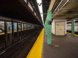
The Forest Hills–71st Avenue station is an express station on the IND Queens Boulevard Line of the New York City Subway, located on Queens Boulevard at 71st (Continental) Avenue in Forest Hills, Queens. It is served by the E and F trains at all times, the <F> train during rush hours in the reverse peak direction, and the R train at all times except late nights. It serves as the terminus for the latter service.

The 75th Avenue station is a local station on the IND Queens Boulevard Line of the New York City Subway. Located at the intersection of 75th Avenue and Queens Boulevard in Forest Hills, Queens, it is served by the F train at all times, the E train at all times except weekday rush hours and middays, and the <F> train during rush hours in the reverse peak direction.

Locust Manor is a station on the Long Island Rail Road's Atlantic Branch in the Locust Manor neighborhood of Queens, New York City. The station is located at Farmers Boulevard and Bedell Street and is 14.0 miles (22.5 km) from Penn Station in Midtown Manhattan. The stop serves the Rochdale, Queens section and its Rochdale Village apartment complex, and was also the stop for the racecourse on which Rochdale Village was erected, Jamaica Race Course. Today it contains fiberglass populuxe designed shelters on high-level platforms.
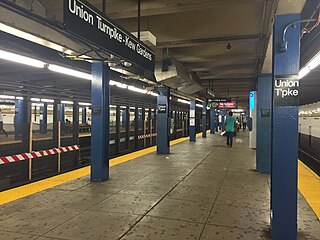
The Kew Gardens–Union Turnpike station is an express station on the IND Queens Boulevard Line of the New York City Subway. Located at Union Turnpike and Queens Boulevard on the border of Kew Gardens and Forest Hills, Queens, it is served by the E and F trains at all times, and the <F> train during rush hours in the reverse peak direction. Despite the station's name, Union Turnpike forms the border between Kew Gardens and Forest Hills, and the station straddles that border, with multiple entrances located in each neighborhood.

The Fifth Avenue/53rd Street station is a station on the IND Queens Boulevard Line of the New York City Subway. Located at the intersection of Fifth Avenue and 53rd Street in Manhattan, it is served by the E and F trains at all times and the <F> train during rush hours in the peak direction.
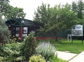
Alley Pond Park is the second-largest public park in Queens, New York City, occupying 655.3 acres (265.2 ha). The park is bordered to the east by Douglaston, to the west by Bayside, to the north by Little Neck Bay, and to the south by Union Turnpike. The Cross Island Parkway travels north-south through the park, while the Long Island Expressway and Grand Central Parkway travel east-west through the park. The park primarily consists of woodlands south of the Long Island Expressway and meadowlands north of the expressway. It is run and operated by the New York City Department of Parks and Recreation.

The Woodhaven Boulevard station is a local station on the IND Queens Boulevard Line of the New York City Subway, consisting of four tracks. Located in Elmhurst, Queens, it is served by the R train at all times except nights, and the E and F trains at night. The station serves the adjacent Queens Center Mall, as well as numerous bus lines.

The Flushing River, also known as Flushing Creek, is a waterway that flows northward through the borough of Queens in New York City, mostly within Flushing Meadows–Corona Park, emptying into the Flushing Bay and the East River. The river runs through a valley that may have been a larger riverbed before the last Ice Age, and it divides Queens into western and eastern halves. Until the 20th century, the Flushing Creek was fed by three tributaries: Mill Creek and Kissena Creek on the eastern bank, and Horse Brook on the western bank.
The Brooklyn Manor station was a station on the Long Island Rail Road's Rockaway Beach Branch located on the south side of Jamaica Avenue at 100th Street, straddling the border between Richmond Hill and Woodhaven in Queens, New York City. The station name referred to the nearby Brooklyn Manor section of Woodhaven, originally a 603-lot development bounded by Woodhaven Boulevard to the west, 96th/98th Streets to the east, Forest Park to the north, and Jamaica Avenue to the south. The station opened in January 1911, and was constructed as a replacement for the Brooklyn Hills station, which was located 3,000 feet (910 m) to the north. This station closed along with the rest of the Rockaway Beach Branch in 1962, and was subsequently demolished.

Roy Wilkins Park, originally known as Southern Queens Park, is a 54-acre (22 ha) park in the St. Albans neighborhood of southeastern Queens in New York City. It is located on an irregular plot of land bounded by 115th and 116th Avenues to the north, 175th Street to the west, Merrick Boulevard to the southwest, Baisley Boulevard to the southeast, and the St. Albans Community Living Center to the east. Roy Wilkins Park contains the Roy Wilkins Recreation Center, a community center with an indoor swimming pool. It also includes various outdoor sporting facilities, a playground, and an artificial pond.
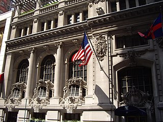
The New York Yacht Club Building is a seven-story Beaux-Arts clubhouse at 37 West 44th Street in the Midtown Manhattan neighborhood of New York City. Opened in 1901, the building was designed by architect Whitney Warren of Warren and Wetmore as the sixth clubhouse of the New York Yacht Club (NYYC). The clubhouse is part of Clubhouse Row, a concentration of clubhouses on 44th Street between Fifth and Sixth Avenues. The building is a New York City designated landmark and is listed on the National Register of Historic Places as a National Historic Landmark.
Douglaston Manor Windmill (c.1870s-1988) was a Dutch windmill built in Littleneck, New York to pump water for farming. Alley Pond Park has a standing windmill that is a replica of the Douglaston Manor windmill. The windmill's tower was relocated to Alley Pond Park after being threatened with demolition in November 1986, having been originally situated on Arleigh Road in Douglaston. A committee formed to save the windmill raised US$50,000 to relocate the structure.
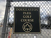 Sign at the entrance of the course
 Douglaston Manor Clubhouse
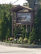 Douglaston Manor entrance sign


