Bethel Acres, Oklahoma

Last updated

Bethel Acres, Oklahoma
Bethel Acres Fire Station and Community Building, Bethel Acres, Oklahoma.jpg
Bethel Acres Community Building
OKMap-doton-BethelAcres.PNG
Location of Bethel Acres, Oklahoma
Coordinates: 35°18′17″N97°02′13″W / 35.30472°N 97.03694°W / 35.30472; -97.03694
Country United States
State Oklahoma
County Pottawatomie
Area
[1]
  Total28.28 sq mi (73.24 km2)
  Land28.27 sq mi (73.22 km2)
  Water0.01 sq mi (0.03 km2)
Elevation
[2]
1,139 ft (347 m)
Population
 (2020)
  Total3,029
  Density107.15/sq mi (41.37/km2)
Time zone UTC-6 (Central (CST))
  Summer (DST) UTC-5 (CDT)
FIPS code 40-05800 [3]
GNIS feature ID2411683 [2]

Bethel Acres is a town in Pottawatomie County, Oklahoma, United States. The population was 2,895 at the time of the 2010 census, an increase of 5.9 percent from the figure of 2,735 in 2000. [4] It is primarily a bedroom community for people who work in the three nearby larger cities of Shawnee, Tecumseh and Oklahoma City.

Contents

History

The area comprising the present Bethel Acres was opened to non-Indian settlement September 22, 1891. The people who settled here established the Bethel school district. Bethel Acres was not incorporated until April 24, 1962, when the residents feared annexation by Shawnee, Tecumseh or Oklahoma City. They wanted to protect their rural lifestyle, especially to be free to keep livestock on their property. [5]

In 1970, Bethel Acres had 1,083 residents. The number jumped to 2,314 in 1980 and has continued to increase through the 2010 census. Over 97 percent of the employed residents commute to work in Oklahoma City, Shawnee and Tecumseh. [5]

On May 19, 2013, an EF4 tornado tore through Northwest Bethel Acres, and a mobile home park sustained a direct hit from this tornado, killing one person and injuring six others, two critically. This was part of the tornado outbreak of May 18–21, 2013.

Geography

Bethel Acres is 4 miles (6.4 km) west of Shawnee. [5]

According to the United States Census Bureau, the town has a total area of 28.2 square miles (73 km2), of which 28.2 square miles (73 km2) is land and 0.04 square miles (0.10 km2) (0.07%) is water.

Demographics

Historical population
CensusPop.Note
1910 388
1970 1,083
1980 2,314113.7%
1990 2,5058.3%
2000 2,7359.2%
2010 2,8955.9%
2020 3,0294.6%
U.S. Decennial Census [6]

As of the census [3] of 2000, there were 2,735 people, 985 households, and 816 families residing in the town. The population density was 96.9 inhabitants per square mile (37.4/km2). There were 1,104 housing units at an average density of 39.1 per square mile (15.1/km2). The racial makeup of the town was 88.56% White, 0.51% African American, 5.92% Native American, 0.33% Asian, 0.04% Pacific Islander, 0.44% from other races, and 4.20% from two or more races. Hispanic or Latino of any race were 1.32% of the population.

There were 985 households, out of which 37.0% had children under the age of 18 living with them, 70.9% were married couples living together, 7.9% had a female householder with no husband present, and 17.1% were non-families. 15.2% of all households were made up of individuals, and 5.6% had someone living alone who was 65 years of age or older. The average household size was 2.72 and the average family size was 3.01.

In the town, the population was spread out, with 27.7% under the age of 18, 6.9% from 18 to 24, 27.5% from 25 to 44, 25.2% from 45 to 64, and 12.7% who were 65 years of age or older. The median age was 38 years. For every 100 females, there were 103.0 males. For every 100 females age 18 and over, there were 97.9 males.

The median income for a household in the town was $43,961, and the median income for a family was $45,000. Males had a median income of $37,390 versus $24,185 for females. The per capita income for the town was $18,826. About 5.3% of families and 6.3% of the population were below the poverty line, including 9.1% of those under age 18 and 6.4% of those age 65 or over.

Education

Four schools make up Bethel Public Schools, including an upper elementary, lower elementary, middle school and Bethel High School. Tod Harrison is the superintendent. [7]

Notable person

Related Research Articles

<span class="mw-page-title-main">Pottawatomie County, Oklahoma</span> County in Oklahoma, United States

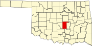
Pottawatomie County is a county located in the U.S. state of Oklahoma. As of the 2020 census, the population was 72,454. Its county seat is Shawnee.

<span class="mw-page-title-main">Park Layne, Ohio</span> Census-designated place in Ohio, United States

Park Layne is a census-designated place (CDP) in Bethel Township, Clark County, Ohio, United States. The population of the CDP was 4,248 at the 2020 census. It is part of the Springfield, Ohio Metropolitan Statistical Area. Park Layne became a CDP in the 1980 United States Census.

<span class="mw-page-title-main">Greenville, Ohio</span> City in Ohio, United States

Greenville is a city in and the county seat of Darke County, Ohio, United States. It is located near Ohio's western edge, about 33 miles (53 km) northwest of Dayton. The population was 12,786 at the 2020 census.

<span class="mw-page-title-main">Tushka, Oklahoma</span> Town in Oklahoma, United States

Tushka is a town in Atoka County, Oklahoma, United States. The population was 312 at the 2010 census, a decline of 9.6 percent from the figure of 345 recorded in 2000.

<span class="mw-page-title-main">Union City, Oklahoma</span> Town in Oklahoma, United States

Union City is a town in Canadian County, Oklahoma, United States. The population was 1,645 at the 2010 census, a 19.6 percent increase from 1,375 in 2000. It is part of the Oklahoma City metropolitan statistical area.

<span class="mw-page-title-main">Bluejacket, Oklahoma</span> Town in Oklahoma, United States

Bluejacket is a town in eastern Craig County, Oklahoma, United States. The population was 339 at the 2010 census, an increase of 23.7 percent over the figure of 274 recorded in 2000.

<span class="mw-page-title-main">Leedey, Oklahoma</span> Town in Oklahoma, United States

Leedey is a town in Dewey County, Oklahoma, United States. The population was 415 at the 2020 census.

<span class="mw-page-title-main">Carney, Oklahoma</span> Town in Oklahoma, United States

Carney is a town in Lincoln County, Oklahoma, United States. As of the 2020 census, the population of the town was 545.

<span class="mw-page-title-main">Warwick, Oklahoma</span> Town in Oklahoma, United States

Warwick is a town in Lincoln County, Oklahoma, United States. The population was 184 at the 2020 census, up from 148 in 2010.

<span class="mw-page-title-main">Cole, Oklahoma</span> Town in Oklahoma, United States

Cole is a town in McClain County, Oklahoma, United States. The population was 624 at the 2020 census, up from 555 at the 2010 census.

<span class="mw-page-title-main">Idabel, Oklahoma</span> City in Oklahoma, United States

Idabel is a city in and the county seat of McCurtain County, Oklahoma, United States. The population was 7,010 at the 2010 census. It is in Oklahoma's southeast corner, a tourist area known as Choctaw Country.

<span class="mw-page-title-main">Sulphur, Oklahoma</span> City in Oklahoma, United States

Sulphur is a city in and county seat of Murray County, Oklahoma, United States. The population was 5,065 at the 2020 census, a 2.8 percent gain over the figure of 4,929 in 2010. The area around Sulphur has been noted for its mineral springs, since well before the city was founded late in the 19th century. The city received its name from the presence of sulfur in the water.

<span class="mw-page-title-main">Harrah, Oklahoma</span> City in Oklahoma, United States

Harrah is a city in Oklahoma County, Oklahoma, United States, and a part of the Oklahoma City metropolitan area. Located 25 miles (40 km) east of downtown Oklahoma City, Harrah had a population of 6,245 people as of the 2020 Census, a 22.6% increase from 2010.

<span class="mw-page-title-main">Warr Acres, Oklahoma</span> City in Oklahoma, United States

Warr Acres is a city in Oklahoma County, Oklahoma, United States, and a part of the Oklahoma City metropolitan area. It was established after World War II by C.B. Warr, a dynamic businessman, builder, and commercial developer. The population was 10,452 at the 2020 census, a 4.1% increase from 2010.

<span class="mw-page-title-main">Wyandotte, Oklahoma</span> Town in Oklahoma, United States

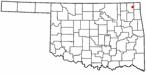
Wyandotte is a town in Ottawa County, Oklahoma, United States. The population was 333 at the 2010 census, a decline of 8.26 percent from the figure of 363 recorded in 2000. The town is the tribal headquarters of the Wyandotte Nation of Oklahoma, for which the town was named.

<span class="mw-page-title-main">Byng, Oklahoma</span> Town in Oklahoma, United States

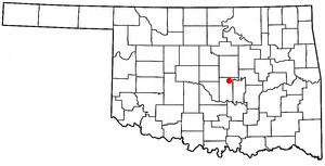
Byng is a town in Pontotoc County, Oklahoma, United States. The population was 1,175 at the 2010 census.

Asher is a town in Pottawatomie County, Oklahoma. The population was 393 at the 2010 census, a decline of 6.2 percent from the figure of 419 in 2000.

<span class="mw-page-title-main">Johnson, Oklahoma</span> Town in Oklahoma, United States

Johnson is a town in north-central Pottawatomie County, Oklahoma, United States. The population was 247 at the 2010 census, a 10.8 percent increase from the figure of 223 in 2000.

<span class="mw-page-title-main">Tecumseh, Oklahoma</span> City in Oklahoma, United States

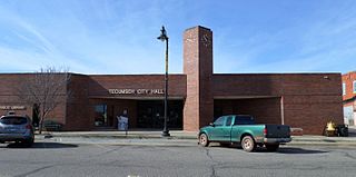
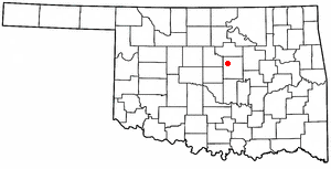
Tecumseh is a city in Pottawatomie County, Oklahoma. The population was 6,302 by the 2020 United States census. It was named for the noted Shawnee chief, Tecumseh. The locale was designated as the county seat at Oklahoma's statehood, but a county-wide election moved the seat to Shawnee in 1930.

<span class="mw-page-title-main">Konawa, Oklahoma</span> City in Oklahoma, United States

Konawa is a city in Seminole County, Oklahoma, United States. The population was 1,288 at the time of the 2020 census. Konawa is a Seminole word meaning, "string of beads."

References

  1. "ArcGIS REST Services Directory". United States Census Bureau. Retrieved September 20, 2022.
  2. 1 2 U.S. Geological Survey Geographic Names Information System: Bethel Acres, Oklahoma
  3. 1 2 "U.S. Census website". United States Census Bureau . Retrieved January 31, 2008.
  4. CensusViewer:Population of the City of Bethel Acres, Oklahoma
  5. 1 2 3 4 Linda D. Wilson, "Bethel Acres," Encyclopedia of Oklahoma History and Culture. Accessed May 23, 2015
  6. "Census of Population and Housing". Census.gov. Retrieved June 4, 2015.
  7. "Bethel Public Schools". Bethel Public Schools. Archived from the original on February 28, 2012. Retrieved March 6, 2012.