Sparks, Oklahoma

Last updated

Sparks, Oklahoma
Sparks Town Hall, Sparks, Oklahoma 2.jpg
Sparks Town Hall
OKMap-doton-Sparks.PNG
Location of Sparks, Oklahoma
Coordinates: 35°36′41″N96°49′08″W / 35.61139°N 96.81889°W / 35.61139; -96.81889
Country United States
State Oklahoma
County Lincoln
Area
[1]
  Total0.41 sq mi (1.06 km2)
  Land0.40 sq mi (1.03 km2)
  Water0.01 sq mi (0.02 km2)
Elevation
[2]
850 ft (260 m)
Population
 (2020)
  Total122
  Density305.76/sq mi (117.93/km2)
Time zone UTC-6 (Central (CST))
  Summer (DST) UTC-5 (CDT)
ZIP code
74869
Area code(s) 539/918
FIPS code 40-68950 [3]
GNIS feature ID2413312 [2]

Sparks is a town in Lincoln County, Oklahoma, United States. The population was 169 at the 2010 census, a 23.4 percent gain from the figure of 137 in 2000. [4] The center of population of Oklahoma is located in Sparks .

Contents

Geography

According to the United States Census Bureau, the town has a total area of 0.4 square miles (1.0 km2), of which 0.4 square miles (1.0 km2) is land and 2.50% is water.

Demographics

Historical population
CensusPop.Note
1910 421
1920 47212.1%
1930 470−0.4%
1940 339−27.9%
1950 233−31.3%
1960 186−20.2%
1970 183−1.6%
1980 772321.9%
1990 202−73.8%
2000 137−32.2%
2010 16923.4%
2020 122−27.8%
U.S. Decennial Census

As of the census [3] of 2000, there were 137 people, 55 households, and 37 families residing in the town. The population density was 354.6 inhabitants per square mile (136.9/km2). There were 73 housing units at an average density of 188.9 per square mile (72.9/km2). The racial makeup of the town was 81.75% White, 3.65% African American, 11.68% Native American, and 2.92% from two or more races. Hispanic or Latino of any race were 0.73% of the population.

There were 55 households, out of which 36.4% had children under the age of 18 living with them, 49.1% were married couples living together, 7.3% had a female householder with no husband present, and 32.7% were non-families. 29.1% of all households were made up of individuals, and 12.7% had someone living alone who was 65 years of age or older. The average household size was 2.49 and the average family size was 3.08.

In the town, the population was spread out, with 29.2% under the age of 18, 5.8% from 18 to 24, 29.2% from 25 to 44, 23.4% from 45 to 64, and 12.4% who were 65 years of age or older. The median age was 36 years. For every 100 females, there were 114.1 males. For every 100 females age 18 and over, there were 110.9 males.

The median income for a household in the town was $20,000, and the median income for a family was $21,750. Males had a median income of $16,875 versus $12,083 for females. The per capita income for the town was $7,715. There were 22.9% of families and 25.4% of the population living below the poverty line, including 40.5% of under eighteens and 7.4% of those over 64.

History

Located on the Deep Fork River in eastern Lincoln County and five miles (8 km) east of State Highway 18 on State Highway 18B, Sparks lies between Meeker and Chandler. The town is situated on land that was once part of the Sac and Fox Reservation, which was dissolved in 1890 when the principal chiefs signed an agreement with the Jerome Commission that each tribal member would receive a 160-acre (0.65 km2) allotment. The surplus land was opened to settlement in a land run on September 22, 1891. The original townsite totaled 186 acres (0.75 km2) and was homesteaded by William and Tabitha Baker.

The Eastern Oklahoma Railway (acquired by Atchison, Topeka and Santa Fe Railway in 1907) and the Fort Smith and Western Railroad (FS&W) established plans for a town at the junction of the two lines as they began surveying Lincoln County in 1902. The town was named in honor of George T. Sparks, an FS&W director. The first school, known as Ball School, was built southeast of Sparks in the late 1890s. In addition, there were two subscription schools, which charged a dollar per pupil per month. A post office was established on August 30, 1902, and the town eventually had approximately fifty businesses. Soon, two newspapers, the Sparks Review and the Sparks Visitor, were published, both Republican in politics. At 1907 statehood the population was 503.

When farm prices fell after World War I and during the Great Depression, people looked elsewhere for employment. In 1920 and 1930 the federal census reported 472 and 470 citizens, respectively. The last bank closed in 1938, and rail service ceased in 1939. By 1940 the population dropped to 339. The high school closed in 1957, and the grade school closed in 1993. The number of citizens declined from 233 in 1950 to 183 in 1970. At the turn of the 21st century the town, with 137 residents, had a post office, a few churches, a rural water district, a volunteer fire department, and two community centers, one in the Old Sparks School Building, which served as a senior citizens' center and town library.

On November 5, 2011, a 5.7-magnitude earthquake occurred near Sparks. At the time, it was the largest earthquake in Oklahoma's history. [5] [6] This record lasted for less than five years; a larger, 5.8-magnitude earthquake broke the record on September 3, 2016. [7] [8]

Related Research Articles

<span class="mw-page-title-main">Pawnee County, Oklahoma</span> County in Oklahoma, United States

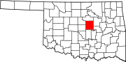
Pawnee County is a county located in the U.S. state of Oklahoma. As of the 2020 census, the population was 15,553. Its county seat is Pawnee. The county is named after the Pawnee Nation, whose reservation used to encompass the county prior to allotment in 1893.

<span class="mw-page-title-main">Greenbrier, Arkansas</span> City in Arkansas, United States

Greenbrier is a city in Faulkner County, Arkansas, United States. It is part of the Central Arkansas region. The population was 5,707 at the 2020 census, up from 4,706 at the 2010 census.

<span class="mw-page-title-main">Guy, Arkansas</span> City in Arkansas, United States

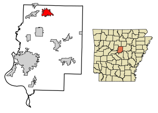
Guy is a city in Faulkner County, Arkansas, United States. The population was 708 at the 2010 census, up from 202 at the 2000 census. It is part of the Central Arkansas region.

<span class="mw-page-title-main">Hollis, Maine</span> Town in the state of Maine, United States

Hollis is a town in York County, Maine, United States. The population was 4,745 at the 2020 census. Hollis is a rural bedroom community of Portland and is part of the Portland–South Portland–Biddeford metropolitan statistical area.

<span class="mw-page-title-main">Sparta, North Carolina</span> Town in North Carolina, United States

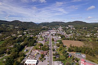
Sparta is a town in Alleghany County, North Carolina, United States. As of the 2020 census, the population of the town was 1,834. It is the county seat of Alleghany County.

<span class="mw-page-title-main">Anna, Ohio</span> Village in Ohio, United States

Anna is a village in Shelby County, Ohio, United States. The population was 1,470 at the 2020 census.

<span class="mw-page-title-main">Dickson, Oklahoma</span> Town in Oklahoma, United States

Dickson is a town in Carter County, Oklahoma, United States. The population was 1,207 at the 2010 census. It is part of the Ardmore, Oklahoma Micropolitan Statistical Area.

<span class="mw-page-title-main">Shattuck, Oklahoma</span> Town in Oklahoma, United States

Shattuck is a town in Ellis County, Oklahoma, United States. The population was 1,249 at the time of the 2020 census, a change from the 1,356 reported in the 2010 census.

<span class="mw-page-title-main">Amber, Oklahoma</span> Town in Oklahoma, United States

Amber is a town in Grady County, Oklahoma, United States. The population was 413 at the 2020 census, a 1.4% decrease from 2010.

<span class="mw-page-title-main">Agra, Oklahoma</span> Town in Oklahoma, United States

Agra is a town in northern Lincoln County, Oklahoma, United States. The population was 339 at the 2010 census. An early real estate developer coined the town's name from the word "agriculture".

<span class="mw-page-title-main">Carney, Oklahoma</span> Town in Oklahoma, United States

Carney is a town in Lincoln County, Oklahoma, United States. As of the 2020 census, the population of the town was 545.

<span class="mw-page-title-main">Davenport, Oklahoma</span> Town in Oklahoma, United States

Davenport is a town in Lincoln County, Oklahoma, United States. The population was 814 at the 2010 census.

<span class="mw-page-title-main">Kendrick, Oklahoma</span> Town in Oklahoma, United States

Kendrick is a town in Lincoln County, Oklahoma, United States. The population was 139 at the 2010 census.

<span class="mw-page-title-main">Meeker, Oklahoma</span> Town in Oklahoma, United States

Meeker is a town in Lincoln County, Oklahoma, United States. The population was 1,145 at the 2010 census.

<span class="mw-page-title-main">Prague, Oklahoma</span> City in Oklahoma, United States

Prague is a city in Lincoln County, Oklahoma, United States. The population was 2,356 at the 2020 census, an 1.76 percent decrease from the figure of 2,388 in 2010. Czech immigrants founded the city, and named it after the capital of the present-day Czech Republic.

<span class="mw-page-title-main">Jones, Oklahoma</span> Town in Oklahoma, United States

Jones is a town in Oklahoma County, Oklahoma. It is named after Charles G. Jones, a three-time mayor of Oklahoma City. The population was 2,692 at the time of the 2010 census.

<span class="mw-page-title-main">Lake Aluma, Oklahoma</span> Town in Oklahoma, United States

Lake Aluma is a town in Oklahoma County, Oklahoma, United States, and a part of the Oklahoma City Metropolitan Area. The population was 88 at the 2010 census.

<span class="mw-page-title-main">Pawnee, Oklahoma</span> City in Oklahoma, United States

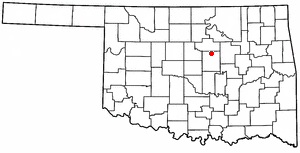
Pawnee is a city and county seat of Pawnee County, Oklahoma, United States. The town is northeast of Stillwater at the junction of U.S. Route 64 and State Highway 18.

<span class="mw-page-title-main">Bradley, Wisconsin</span> Town in Wisconsin, United States

Bradley is a town in Lincoln County, Wisconsin, United States. The population was 2,408 at the 2010 census, down from 2,573 at the 2000 census. The unincorporated communities of Bradley, Gilbert, Heafford Junction, and West Kraft are located in the town.

<span class="mw-page-title-main">Verdi, Nevada</span> Census-designated place in Nevada, United States

Verdi is a census-designated place (CDP) in Washoe County, Nevada, United States. It is on the western side of the Reno–Sparks Metropolitan Statistical Area, near Interstate 80 and stretches eastward towards its neighborhood-exclave of Lawton, Nevada surrounded by Reno, Nevada west of Mae Anne Avenue. The CDP of Verdi, California lies immediately adjacent across the state line. Both are in the shadow of California's Verdi Range. In 2010, the population was 1,415. Prior to 2010, the community was listed by the U.S. Census Bureau as part of the Verdi-Mogul CDP.

References

  1. "ArcGIS REST Services Directory". United States Census Bureau. Retrieved September 20, 2022.
  2. 1 2 U.S. Geological Survey Geographic Names Information System: Sparks, Oklahoma
  3. 1 2 "U.S. Census website". United States Census Bureau . Retrieved January 31, 2008.
  4. CensusViewer:Sparks, Oklahoma Population Retrieved January 22, 2014.
  5. Oklahoma's largest quake buckles highway; 1 injured, CNN.com (November 6, 2011)
  6. Magnitude 5.6 - OKLAHOMA: 2011 November 06 03:53:10 UTC, USGS.gov (November 6, 2011)
  7. "M5.8 - 15km NW of Pawnee, Oklahoma". Earthquake Hazards Program. United States Geological Survey. September 7, 2016. Retrieved September 20, 2016.
  8. "Magnitudes for Oklahoma Earthquakes Shift Upward". United States Geological Survey. September 7, 2016. Retrieved September 20, 2016.