Warr Acres, Oklahoma

Last updated

Warr Acres, Oklahoma
Oklahoma County Oklahoma Incorporated and Unincorporated areas Warr Acres highlighted.svg
Location in Oklahoma County and the state of Oklahoma.
Usa edcp location map.svg
Red pog.svg
Warr Acres, Oklahoma
Location in the United States
Coordinates: 35°31′42″N97°37′06″W / 35.52833°N 97.61833°W / 35.52833; -97.61833
Country United States
State Oklahoma
County Oklahoma
Area
[1]
  Total2.84 sq mi (7.35 km2)
  Land2.80 sq mi (7.26 km2)
  Water0.03 sq mi (0.09 km2)
Elevation
[2]
1,319 ft (402 m)
Population
 (2020)
  Total10,452
  Density3,728.86/sq mi (1,439.86/km2)
Time zone UTC-6 (Central (CST))
  Summer (DST) UTC-5 (CDT)
ZIP codes
73122, 73123, 73132
Area code 405
FIPS code 40-78500 [3]
GNIS feature ID2412182 [2]
Website www.warracres-ok.gov

Warr Acres is a city in Oklahoma County, Oklahoma, United States, and a part of the Oklahoma City metropolitan area. It was established after World War II by C.B. Warr, a dynamic businessman, builder, and commercial developer. [4] The population was 10,452 at the 2020 census, a 4.1% increase from 2010. [5]

Contents

The city lies within the Putnam City School District.

History

The Warr Acres housing addition and Warr Acres Second Addition was developed in 1937 by Clyde B. Warr. [4] An addition that would later form part of the city of Warr Acres, Putnam City was developed by state lawmaker Israel Putnam in 1909. [4]

The city formed when the residents of 11 additions, including Putnam City, petitioned to incorporate in February 1948. [4] The city of Bethany filed suit, but lost in an Oklahoma Supreme Court decision. [4]

Warr Acres was a racially segregated community that used restrictive covenants and extra-legal means to prevent African-Americans from owning properties from its founding through the 1960's. [6] [7] [8]

Shopping districts appeared along MacArthur Avenue in the 1960s and 1970s. [4] By 1979, the town had grown to three square miles after annexing several residential developments. [4]

Geography

Warr Acres is a northwest suburb of Oklahoma City. According to the United States Census Bureau, the city has a total area of 2.8 square miles (7.3 km2) centered along N MacArthur Boulevard, of which 2.8 square miles (7.3 km2) is land and 0.04 square miles (0.10 km2) (1.06%) is water. The city lies in the Sandstone Hills region of Oklahoma, known for hills of 250 to 400 feet (120 m) and forests of blackjack oak and post oak. [9]

Climate

Warr Acres has a humid subtropical climate, with variations in weather daily and seasonally, except during summer, which is consistently hot and humid. Central Oklahoma is subject to droughts and heavy rainfall leading to flash flooding and flooding. Consistent winds help cool the summers and can lead to winter ice storms. Warr Acres is in the center of Tornado Alley and is prone to frequent and severe tornadoes. The Oklahoma City metropolitan area is one of the most tornado-prone major cities in the world. More than 150 tornadoes have struck within the city limits since 1890, including eight rated F4/EF4 and one rated F5. [10]

Demographics

Historical population
CensusPop.Note
1950 2,378
1960 7,135200.0%
1970 9,88738.6%
1980 9,9400.5%
1990 9,288−6.6%
2000 9,7354.8%
2010 10,0433.2%
2020 10,4524.1%
Sources: [3] [11] [12] [13] [14]

According to the 2020 U.S. Census, the racial composition of Warr Acres was as follows: [15]

As of the 2010 census, there were 10,043 people, 3,945 households, and 2,600 families residing in the city. The population density was 3,586.8 people per square mile. The population was relatively unchanged since the 2000 census recorded 9,735 people, 3,978 households, and 2,681 families. Households with children under the age of 18 make up 34.5% of the 3,945 households and 43.5% were occupied by married couples living together. [5] Non-family households make up 33.9% of the total households and 16.4% were occupied by a female householder with no husband present. [5] The average household size was 2.52 and the average family size was 3.07. [5]

The median income for a household in the city was $40,941, and the median income for a family was $50,533. [5] The per capita income for the city was $29,966. [5] About 13.8% of families, 75.2% of employees and 16.6% of the population were below the poverty line, including 30.2% of those under age 18 and 3.3% of those age 65 or over. [5]

City government

Warr Acres Fire Dept. Engine 23 at a local Walmart Neighborhood Market. WAFD Engine 23.jpg
Warr Acres Fire Dept. Engine 23 at a local Walmart Neighborhood Market.

The city provides residents with a fire department, police department, animal control, and sewer and sanitation services. [16] The Warr Acres fire department consists of 20 paid employees that respond to more than 1,800 calls per year. [17] The police department consists of 26 paid employees divided up into patrol, investigative, communications, and administrative divisions. The Patrol Division is the primary contact for citizens. [18]

Education

As a northwest suburb of Oklahoma City, Warr Acres is close to Oklahoma City University, the Southern Nazarene University, Southwestern Christian University and Oklahoma Christian University.

The city is serviced by the Putnam City School District. [19] Schools in Warr Acres include: [20]

The Putnam City Enrollment Center is also in Warr Acres. [20]

A portion of Warr Acres is zoned to Putnam City West High School in Oklahoma City. [21]

The Roman Catholic Archdiocese of Oklahoma City operates St. Charles Borromeo Catholic K-8 School. [20]

Related Research Articles

<span class="mw-page-title-main">Pottawatomie County, Oklahoma</span> County in Oklahoma, United States

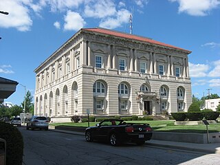
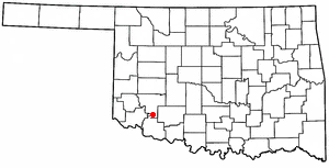
Pottawatomie County is a county located in the U.S. state of Oklahoma. As of the 2020 census, the population was 72,454. Its county seat is Shawnee.

<span class="mw-page-title-main">Oklahoma County, Oklahoma</span> County in Oklahoma, United States

Oklahoma County is located in the central part of the U.S. state of Oklahoma. As of the 2020 census, the population was 796,292, making it the most populous county in Oklahoma. The county seat is Oklahoma City, the state capital and largest city. Oklahoma County is at the heart of the Oklahoma City metropolitan statistical area.

<span class="mw-page-title-main">Harrison, Ohio</span> City in Ohio, United States

Harrison is a city in western Hamilton County, Ohio, United States. The population was 12,563 at the 2020 census. It is part of the Cincinnati metropolitan area.

<span class="mw-page-title-main">Ottawa, Ohio</span> Village in Ohio, US

Ottawa is a village and the county seat of Putnam County, Ohio, United States. It is located about 51 miles (82 km) southwest of Toledo. The population is 4,456 as of the 2020 census.

<span class="mw-page-title-main">El Reno, Oklahoma</span> City in Oklahoma, United States

El Reno is a city in and county seat of Canadian County, Oklahoma, United States. As of the 2020 census, the city population was 16,989, marking a change of 1.55% from 16,729, recorded in the 2010 census. The city was begun shortly after the 1889 land rush and named for the nearby Fort Reno. It is located in Central Oklahoma, about 25 miles (40 km) west of downtown Oklahoma City.

<span class="mw-page-title-main">Union City, Oklahoma</span> Town in Oklahoma, United States

Union City is a town in Canadian County, Oklahoma, United States. The population was 1,645 at the 2010 census, a 19.6 percent increase from 1,375 in 2000. It is part of the Oklahoma City metropolitan statistical area.

<span class="mw-page-title-main">Moore, Oklahoma</span> City in Oklahoma, United States

Moore is a city in Cleveland County, Oklahoma, United States, and is part of the Oklahoma City metropolitan area. The population was 62,793 at the 2020 census, making Moore the seventh-largest city in the state of Oklahoma.

<span class="mw-page-title-main">Lindsay, Oklahoma</span> City in Oklahoma, United States

Lindsay is a city in Garvin County, Oklahoma, United States. The population was 2,840 at the 2010 census. It once promoted itself as "The Broomcorn Capital of the World" but no longer uses that slogan, as broomcorn is no longer raised in the area.

<span class="mw-page-title-main">Snyder, Oklahoma</span> City in Oklahoma, United States

Snyder is a city in Kiowa County, Oklahoma, United States. The population was 1,394 at the 2010 census. This figure represented a decline of 7.6 percent from 1,509 persons in 2000.

<span class="mw-page-title-main">Newcastle, Oklahoma</span> City in Oklahoma, United States

Newcastle is a city in McClain County, Oklahoma, United States, and part of the Oklahoma City Metropolitan Area. The population was 10,984 at the 2020 census.

<span class="mw-page-title-main">Idabel, Oklahoma</span> City in Oklahoma, United States

Idabel is a city in and the county seat of McCurtain County, Oklahoma, United States. The population was 7,010 at the 2010 census. It is in Oklahoma's southeast corner, a tourist area known as Choctaw Country.

<span class="mw-page-title-main">Bethany, Oklahoma</span> City in Oklahoma, United States

Bethany is a city in Oklahoma County, Oklahoma, United States, and a part of the Oklahoma City metropolitan area. Bethany has a population of 20,831 at the 2020 census, a 9.3% increase from 2010. The community was founded in 1909 by followers of the Church of the Nazarene from Oklahoma City.

<span class="mw-page-title-main">Choctaw, Oklahoma</span> City in Oklahoma, United States

Choctaw is a city in Oklahoma County, Oklahoma, United States, with a population of 12,182 at the 2020 census, a 9.3% increase from 2010. It is the oldest chartered town in Oklahoma Territory. The city is located approximately 10 miles (16.1 km) east of Oklahoma City and is part of the Oklahoma City metropolitan area.

<span class="mw-page-title-main">Del City, Oklahoma</span> City in Oklahoma, United States

Del City is a city in Oklahoma County, Oklahoma, United States, and a part of the Oklahoma City metropolitan area. The population was 21,822 at the United States Census, 2020, a 2.3% increase from 2010.

<span class="mw-page-title-main">Harrah, Oklahoma</span> City in Oklahoma, United States

Harrah is a city in Oklahoma County, Oklahoma, United States, and a part of the Oklahoma City metropolitan area. Located 25 miles (40 km) east of downtown Oklahoma City, Harrah had a population of 6,245 people as of the 2020 Census, a 22.6% increase from 2010.

<span class="mw-page-title-main">Woodlawn Park, Oklahoma</span> Town in Oklahoma, United States

Woodlawn Park is a town in Oklahoma County, Oklahoma, United States, and a part of the Oklahoma City Metropolitan Area. The population was 161 at the 2000 census.

<span class="mw-page-title-main">Bethel Acres, Oklahoma</span> Town in Oklahoma, United States

Bethel Acres is a town in Pottawatomie County, Oklahoma, United States. The population was 2,895 at the time of the 2010 census, an increase of 5.9 percent from the figure of 2,735 in 2000. It is primarily a bedroom community for people who work in the three nearby larger cities of Shawnee, Tecumseh and Oklahoma City.

<span class="mw-page-title-main">Tecumseh, Oklahoma</span> City in Oklahoma, United States

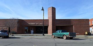
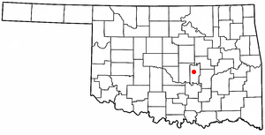
Tecumseh is a city in Pottawatomie County, Oklahoma. The population was 6,302 by the 2020 United States census. It was named for the noted Shawnee chief, Tecumseh. The locale was designated as the county seat at Oklahoma's statehood, but a county-wide election moved the seat to Shawnee in 1930.

<span class="mw-page-title-main">Seminole, Oklahoma</span> City in Oklahoma, United States

Seminole is a city in Seminole County, Oklahoma, United States. The population was 7,488 at the 2010 census. Seminole experienced a large population growth in the 1920s due to an oil boom.

<span class="mw-page-title-main">Clinton, Oklahoma</span> City in Oklahoma, United States

Clinton is a city in Custer and Washita counties in the U.S. state of Oklahoma. The population was 8,521 at the time of the 2020 census.

References

  1. "ArcGIS REST Services Directory". United States Census Bureau. Retrieved September 20, 2022.
  2. 1 2 U.S. Geological Survey Geographic Names Information System: Warr Acres, Oklahoma
  3. 1 2 "U.S. Census website". United States Census Bureau . Retrieved January 31, 2008.
  4. 1 2 3 4 5 6 7 Everett, Dianna, "Warr Acres," Encyclopedia of Oklahoma History and Culture (accessed March 5, 2015).
  5. 1 2 3 4 5 6 7 Search of Warr Acres city, Oklahoma at U.S. Census website, United States Census. (accessed June 30, 2019)
  6. Williams, Payton "A forgotten Oklahoma story gets retold" The Lawton Constitution (Aug. 16, 2022) (accessed May 22, 2024)
  7. Janda, Sara Eppler The list is Herland: Gendered activism in Oklahoma from the 1870s to the 2010s) (Vol. 1)(2021)
  8. Coleman Spoke: A mother, a son, civil rights, Vietnam (2022)
  9. Oklahoma Geography, NetState.com. (accessed August 2, 2013)
  10. "Tornadoes Which Have Occurred in the Oklahoma City, Oklahoma Area Since 1890". National Weather Service Norman Oklahoma. 2013. Retrieved August 2, 2013.
  11. "Population-Oklahoma" (PDF). U.S. Census 1910. U.S. Census Bureau. Retrieved November 22, 2013.
  12. "Population-Oklahoma" (PDF). 15th Census of the United States. U.S. Census Bureau. Retrieved November 27, 2013.
  13. "Number of Inhabitants: Oklahoma" (PDF). 18th Census of the United States. U.S. Census Bureau. Retrieved November 22, 2013.
  14. "Oklahoma: Population and Housing Unit Counts" (PDF). U.S. Census Bureau. Retrieved November 22, 2013.
  15. "Explore Census Data".
  16. City of Warr Acres
  17. City of Warr Acres: Fire Department (accessed August 3, 2013)
  18. City of Warr Acres: Police Department (accessed August 3, 2013)
  19. "2020 CENSUS - SCHOOL DISTRICT REFERENCE MAP: Oklahoma County, OK" (PDF). U.S. Census Bureau . Retrieved January 28, 2024.
  20. 1 2 3 "How do I enroll my child in school?". City of Warr Acres. Retrieved January 28, 2024.
  21. "Putnam City West High School Boundaries". Putnam City Public Schools . Retrieved January 28, 2024. - Linked from here, compare to Warr Acres boundaries.