Etowah, Oklahoma

Last updated

Etowah, Oklahoma
Cleveland County, Oklahoma Incorporated and Unincorporated areas highlighting Etowah.svg
Location of Etowah, Oklahoma.
Coordinates: 35°07′15″N97°10′07″W / 35.12083°N 97.16861°W / 35.12083; -97.16861
Country United States
State Oklahoma
County Cleveland
Area
[1]
  Total1.99 sq mi (5.16 km2)
  Land1.99 sq mi (5.15 km2)
  Water0.00 sq mi (0.01 km2)
Elevation
[2]
1,076 ft (328 m)
Population
 (2020)
  Total159
  Density80.02/sq mi (30.90/km2)
Time zone UTC-6 (Central (CST))
  Summer (DST) UTC-5 (CDT)
FIPS code 40-24460 [3]
GNIS feature ID2412604 [2]

Etowah is a town in Cleveland County, Oklahoma, United States. The population was 159 at the 2020 census, a 72.8% increase from 2010.

Contents

Geography

According to the United States Census Bureau, the town has a total area of 2.0 square miles (5.2 km2), all land.

Demographics

Historical population
CensusPop.Note
1990 33
2000 122269.7%
2010 92−24.6%
2020 15972.8%
U.S. Decennial Census [4]

At the 2010 census, there were 92 people, 42 households, and 34 families in the town. The population density was 59.4 inhabitants per square mile (22.9/km2). There were 50 housing units at an average density of 21.4 per square mile (8.3/km2). The racial makeup of the town was 93.44% White, 0.82% Native American, and 5.74% from two or more races. Hispanic or Latino of any race were 3.28% of the population.

Of the 42 households 45.2% had children under the age of 18 living with them, 78.6% were married couples living together, and 19.0% were non-families. 19.0% of households were one person and 4.8% were one person aged 65 or older. The average household size was 2.90 and the average family size was 3.32.

The age distribution was 32.0% under the age of 18, 11.5% from 18 to 24, 32.8% from 25 to 44, 18.0% from 45 to 64, and 5.7% 65 or older. The median age was 31 years. For every 100 females, there were 121.8 males. For every 100 females age 18 and over, there were 102.4 males.

The median household income was $34,375 and the median family income was $34,375. Males had a median income of $26,786 versus $25,833 for females. The per capita income for the town was $10,190. None of the population and none of the families were below the poverty line.

Related Research Articles

<span class="mw-page-title-main">Etowah County, Alabama</span> County in Alabama, United States

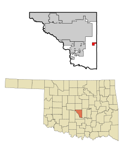
Etowah County is a county located in the northeastern part of the U.S. state of Alabama. As of the 2020 census the population was 103,436. Its county seat is Gadsden. Its name is from a Cherokee word meaning "edible tree". In total area, it is the smallest county in Alabama, but one of the most densely populated. Etowah County comprises the Gadsden Metropolitan Statistical Area.

<span class="mw-page-title-main">Hokes Bluff</span> City in Alabama, United States

Hokes Bluff is a city in Etowah County, Alabama, United States. It is part of the Gadsden Metropolitan Statistical Area. At the 2020 census, the population was 4,446.

<span class="mw-page-title-main">Ridgeville, Alabama</span> Town in Alabama, United States

Ridgeville is a town in Etowah County, Alabama, United States. It incorporated in 1969 and is part of the Gadsden Metropolitan Statistical Area. At the 2020 census the population was 83, down from 158 in 2000. It is noteworthy for being the only community in Etowah County to have a black majority. Since 1970, it has also been the least populated community wholly within the county.

<span class="mw-page-title-main">Sardis City, Alabama</span> Town in Alabama, United States

Sardis City is a town in Etowah and Marshall counties in the U.S. state of Alabama. It is part of the Gadsden Metropolitan Statistical Area. It originally incorporated in May 1963 under the name of "Sardis". It became Sardis City in the 1980s. At the 2020 census, the population was 1,814.

<span class="mw-page-title-main">Hamlin, Kansas</span> City in Brown County, Kansas

Hamlin is a city in Brown County, Kansas, United States. As of the 2020 census, the population of the city was 25.

<span class="mw-page-title-main">Eagle Lake, Maine</span> Town in the state of Maine, United States

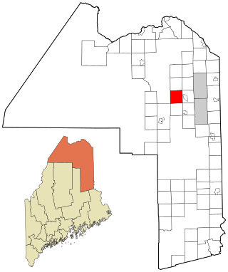
Eagle Lake is a town in Aroostook County, Maine, United States. The population was 772 at the 2020 census. The town was named by a body of troops heading from Bangor to the Aroostook War for the many eagles that they saw around the lake. A total of 49.0% of the population speaks French, reflecting a trend in Northeastern Maine.

<span class="mw-page-title-main">Wade, Maine</span> Town in the state of Maine, United States

Wade is a town in Aroostook County, Maine, United States. The population was 229 at the 2020 census.

<span class="mw-page-title-main">Byron, Maine</span> Town in the state of Maine, United States

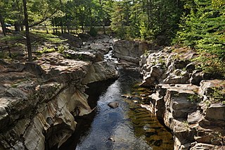
Byron is a town in Oxford County, Maine, United States. The population was 103 at the 2020 census. Home to Coos Canyon on the Swift River, Byron includes the village of Houghton.

<span class="mw-page-title-main">Troy, Maine</span> Town in the state of Maine, United States

Troy is a town in Waldo County, Maine, United States. The population was 1,018 at the 2020 census.

<span class="mw-page-title-main">Etowah, North Carolina</span> Census-designated place in Henderson County, North Carolina, USA

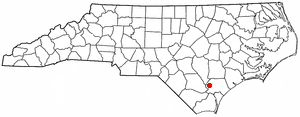
Etowah is an unincorporated community and census-designated place (CDP) in Henderson County, North Carolina, United States. The population was 6,944 at the 2010 census. It is part of the Asheville Metropolitan Statistical Area.

<span class="mw-page-title-main">Atkinson, North Carolina</span> Town in North Carolina, United States

Atkinson is a town in Pender County, North Carolina, United States. At the 2010 census, the town population was 299. It is part of the Wilmington Metropolitan Statistical Area. The town was incorporated in 1989.

<span class="mw-page-title-main">Brice, Ohio</span> Village in Ohio, United States

Brice is a village in Franklin County, Ohio, United States, on the southeast side of the Columbus metropolitan area. The population was 93 at the 2020 census.

<span class="mw-page-title-main">Forward Township, Allegheny County, Pennsylvania</span> Township of Allegheny County, Pennsylvania

Forward Township is a township in Allegheny County, Pennsylvania, United States. The population was 3,068 at the 2020 census. The township is named after Walter Forward, U.S. Secretary of the Treasury from 1841 to 1843.

<span class="mw-page-title-main">Dolton, South Dakota</span> Town in South Dakota, United States

Dolton is a town in Turner County, South Dakota, United States. The population was 34 at the 2020 census.

<span class="mw-page-title-main">Strongs Prairie, Wisconsin</span> Town in Wisconsin, United States

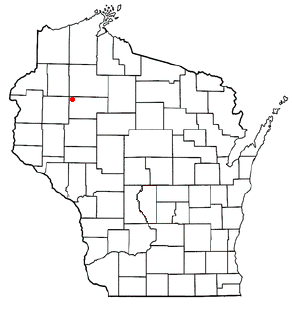
The Town of Strongs Prairie is located in Adams County in the U.S. state of Wisconsin. The population was 1,150 at the 2010 census. The unincorporated communities of Arkdale, Dellwood, and Strongs Prairie are located within the town.

<span class="mw-page-title-main">Wascott, Wisconsin</span> Town in Wisconsin, United States

Wascott is a town in Douglas County, Wisconsin, United States. The population was 714 at the 2000 census. The unincorporated community of Wascott is located in the town.

<span class="mw-page-title-main">Peru, Wisconsin</span> Town in Wisconsin, United States

The Town of Peru is a Town located in Dunn County, Wisconsin, United States. The population was 247 at the 2000 census. The unincorporated communities of Meridean and Red Cedar and the ghost towns of Old Tyrone and Old Meridean are located in the town.

<span class="mw-page-title-main">Centerville, Manitowoc County, Wisconsin</span> Town in Wisconsin, United States

Centerville is a town in Manitowoc County, Wisconsin, United States. The population was 713 at the 2000 census. The town is divided by I-43 and surrounds the Village of Cleveland.

<span class="mw-page-title-main">Wilson, Rusk County, Wisconsin</span> Town in Wisconsin, United States

Wilson is a town in Rusk County, Wisconsin, United States. The population was 84 at the 2000 census.

<span class="mw-page-title-main">Gale, Wisconsin</span> Town in Wisconsin, United States

Gale is a town in Trempealeau County, Wisconsin, United States. The population was 1,426 at the 2000 census. The unincorporated communities of Butman Corners and Frenchville are located in the town.

References

  1. "ArcGIS REST Services Directory". United States Census Bureau. Retrieved September 20, 2022.
  2. 1 2 U.S. Geological Survey Geographic Names Information System: Etowah, Oklahoma
  3. "U.S. Census website". United States Census Bureau . Retrieved January 31, 2008.
  4. "Census of Population and Housing". Census.gov. Retrieved June 4, 2015.