Grundy is a town in Buchanan County, Virginia, United States, an area located within the Appalachian Mountains region. It is the county seat of Buchanan County. The town is home to the Appalachian School of Law. The population was 875 as of the 2020 census.

Haysi is a town in Dickenson County, Virginia, United States. The population was 498 at the 2010 census, up from 186 at the 2000 census, over which time period the town's area tripled.

The Cumberland River is a major waterway of the Southern United States. The 688-mile-long (1,107 km) river drains almost 18,000 square miles (47,000 km2) of southern Kentucky and north-central Tennessee. The river flows generally west from a source in the Appalachian Mountains to its confluence with the Ohio River near Paducah, Kentucky, and the mouth of the Tennessee River. Major tributaries include the Obey, Caney Fork, Stones, and Red Rivers.
The Powell River is a 195-mile-long river in the United States that rises in Southwest Virginia and flows southwest into East Tennessee.

Peachtree Creek is a major stream in Atlanta. It flows for 7.5 miles (12.1 km) almost due west into the Chattahoochee River just south of Vinings.
Accoville is an unincorporated community and census-designated place (CDP) in Logan County, West Virginia, United States. The community lies along Buffalo Creek. As of the 2010 United States Census, its population was 574.

Breaks Interstate Park is a bi-state state park located partly in southeastern Kentucky and mostly in southwestern Virginia, in the Jefferson National Forest, at the northeastern terminus of Pine Mountain. Rather than their respective state park systems, it is instead administered by an interstate compact between the states of Virginia and Kentucky. It is one of several interstate parks in the United States, but only one of two operated jointly under a compact rather than as two separate state park units. The Virginia Department of Conservation and Recreation and the Kentucky Department of Parks are still major partner organizations.
Prices Fork is a small traditionally agricultural census-designated place (CDP), in Montgomery County, Virginia, United States. The population as of the 2010 Census was 1,066. It is located about three miles west of Blacksburg and the campus of Virginia Polytechnic Institute and State University.
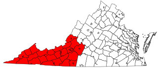
Southwest Virginia, often abbreviated as SWVA, is a mountainous region of Virginia in the westernmost part of the commonwealth. Located within the broader region of western Virginia, Southwest Virginia has been defined alternatively as all Virginia counties on the Appalachian Plateau, all Virginia counties west of the Eastern Continental Divide, or at its greatest expanse, as far east as Blacksburg and Roanoke. Another geographic categorization of the region places it as those counties within the Tennessee River watershed. Regardless of how borders are drawn, Southwest Virginia differs from the rest of the commonwealth in that its culture is more closely associated with Appalachia than the other regions of Virginia. Historically, the region has been and remains a rural area, but in the 20th century, coal mining became an important part of its economy. With the decline in the number of coal jobs and the decline of tobacco as a cash crop, Southwest Virginia is increasingly turning to tourism as a source of economic development. Collectively, Southwest Virginia's craft, music, agritourism and outdoor recreation are referred to as the region's "creative economy."

Bays Mountain is a ridge of the Ridge-and-Valley Appalachians, located in eastern Tennessee. It runs southwest to northeast, from just south of Knoxville to Kingsport.
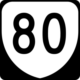
State Route 80 is a primary state highway in the southwest part of the U.S. state of Virginia. It runs from the Kentucky state line at Breaks Interstate Park east to U.S. Route 11 near Meadowview. Kentucky Route 80 and Missouri's Route 80 continue the number west to Matthews, Missouri. The entire length of SR 80 is part of U.S. Bicycle Route 76.

Mouthcard is a small unincorporated community in Pike County, Kentucky, United States near the Virginia state line. It lies on the Levisa Fork River of the Big Sandy River in the heart of the Appalachians. U.S. Route 460 runs through Mouthcard to meet U.S. Route 23 in Pikeville, the county seat.

North Fork Mountain is a quartzite-capped mountain ridge in the Ridge and Valley physiographic province of the Allegheny Mountains, also known as the High Alleghenies or Potomac Highlands, of eastern West Virginia. Kile Knob, at 4,588 feet, is the mountain's highest point, and Panther Knob and Pike Knob are nearly as high.

Hurley is an unincorporated community in Buchanan County, Virginia located at the convergence of County Routes 643, 646, 650, and 697, a short distance from the Kentucky and West Virginia state lines.
Tuckasegee, named after the historic Cherokee town of that name located near here, is an unincorporated community in Jackson County, North Carolina, United States. It followed the earlier Cherokee town as developing on the upper Tuckaseegee River, at the confluence of its East and West forks.

John W. Flannagan Dam is a flood control dam located in the Cumberland Mountains of Dickenson County, Virginia. It forms the John W. Flannagan Reservoir behind it. It was named after Congressman John Williams Flannagan, Jr.

Dante is a census-designated place in Russell and Dickenson counties, Virginia, in the United States. The population as of the 2010 Census was 649.
Forest Glen is an unincorporated community in Trinity County, California, United States. Forest Glen is located on California State Route 36, 14.5 miles (23.3 km) south-southwest of Hayfork. With a population around 10 permanent residents and 20 seasonal Forest Service cabin owners, visitors often drive right through in 30 seconds little realizing there was a town.

The Eastern Magisterial District is one of three magisterial districts in Jackson County, West Virginia, United States. It was established during a process of redistricting undertaken in the 1990s. In 2010, 9,882 people lived in the district.