Russell County is a county located in the Commonwealth of Virginia. As of the 2010 census, the population was 28,897. Its county seat is Lebanon.
Dickenson County is a county located in the Commonwealth of Virginia. As of the 2010 census, the population was 15,903. Its county seat is Clintwood.

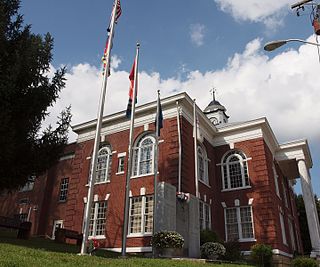
Clintwood is a town in Dickenson County, Virginia, United States. The population was 1,414 at the 2010 census, with an estimated population of 1,304 in 2018. It is the county seat of Dickenson County.

Haysi is a town in Dickenson County, Virginia, United States. The population was 498 at the 2010 census, up from 186 at the 2000 census, over which time period the town's area tripled. The pronunciation of the final syllable is that of "sigh".

State Route 83 is a primary state highway in the U.S. state of Virginia. The state highway runs 61.71 miles (99.31 km) from U.S. Route 23 Business in Pound east to the West Virginia state line in Paynesville, where the highway continues as West Virginia Route 83. SR 83 is the main highway of Dickenson County, where it connects the county's three towns of Clintwood, Clinchco, and Haysi. The state highway connects those towns with Pound in Wise County and Grundy in Buchanan County, and connects Grundy with McDowell County, West Virginia.

State Route 63 is a primary state highway in the U.S. state of Virginia. The state highway runs 39.28 miles (63.22 km) from U.S. Route 58 Alternate in St. Paul north to SR 80 and SR 83 in Haysi.

Nora is an unincorporated community in Dickenson County in the southern U.S. state of Virginia. In the 2000 US census, its population is listed as 566. Nora is situated along the McClure River.

This is a list of the National Register of Historic Places listings in Dickenson County, Virginia.

Trammel is an unincorporated community in Dickenson County, Virginia, United States. Trammel is located along Virginia State Route 63 7.6 miles (12.2 km) north of St. Paul. Trammel had a post office with ZIP code 24289 from October 8, 1919, to November 16, 2002; the community is now part of ZIP code 24237.
Fremont is an unincorporated community in Dickenson County, Virginia, in the United States.
Aily is an unincorporated community in Dickenson County, Virginia, in the United States.
Isom is an unincorporated community in Dickenson County, Virginia, in the United States.
Millard is an unincorporated community in Dickenson County, Virginia, in the United States.
Skeetrock is an unincorporated community in Dickenson County, Virginia, in the United States.
Stratton is an unincorporated community in Dickenson County, Virginia, in the United States.
Tarpon is an unincorporated community in Dickenson County, Virginia, in the United States.
Viers is an unincorporated community in Dickenson County, Virginia, in the United States.
Wakenva is an unincorporated community in Dickenson County, Virginia, in the United States.
Virginia's 4th House of Delegates district is one of 100 seats in the Virginia House of Delegates, the lower house of the state's bicameral legislature. District 4 covers all of Dickenson County and portions of Russell County, Washington County, and Wise County, Virginia. The district is represented by Republican Delegate Will Wampler

John Calhoun Dickenson was a Virginia planter and politician who served in both chambers of the Virginia General Assembly, including in the Virginia Senate during the American Civil War and after Congressional Reconstruction ended, and is usually referred to with the honorific "Colonel", perhaps alluding to his service with the Home Guard during the American Civil War.