The Sierra Nevada is a mountain range in the Western United States, between the Central Valley of California and the Great Basin. The vast majority of the range lies in the state of California, although the Carson Range spur lies primarily in Nevada. The Sierra Nevada is part of the American Cordillera, an almost continuous chain of mountain ranges that forms the western "backbone" of the Americas.

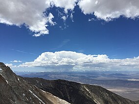
The Great Basin Desert is part of the Great Basin between the Sierra Nevada and the Wasatch Range. The desert is a geographical region that largely overlaps the Great Basin shrub steppe defined by the World Wildlife Fund, and the Central Basin and Range ecoregion defined by the U.S. Environmental Protection Agency and United States Geological Survey. It is a temperate desert with hot, dry summers and snowy winters. The desert spans large portions of Nevada and Utah, and extends into eastern California. The desert is one of the four biologically defined deserts in North America, in addition to the Mojave, Sonoran, and Chihuahuan Deserts.

Mount Baxter is a peak along the crest of the Sierra Nevada in California. Mount Baxter is on the boundary between Kings Canyon National Park and the John Muir Wilderness just north of Baxter Pass and to the northeast of the Rae Lakes, a popular backpacking destination along the John Muir Trail.

Boundary Peak is a mountain in Esmeralda County, Nevada, United States. With a peak elevation of 13,147 feet (4,007 m), it is the highest natural point in the state of Nevada.

Montgomery Peak is a mountain in the White Mountains of California, USA. It is less than 1 mile (1.6 km) from Boundary Peak, the highest point in Nevada; and it is taller than Boundary Peak. Boundary Peak has a prominence of less than 300 feet. Montgomery can be climbed in combination with Boundary Peak. The two peaks are in the Inyo National Forest and White Mountains Wilderness. Montgomery Peak is in Inyo County (California), and Boundary Peak is in Esmeralda County, in Nevada.

The Jarbidge Wilderness is a wilderness area located in the Jarbidge Mountains of northern Elko County in northeastern Nevada, United States. It is contained within the Jarbidge Ranger District of the Humboldt-Toiyabe National Forest.

Inyo National Forest is a United States National Forest covering parts of the eastern Sierra Nevada of California and the White Mountains of California and Nevada. The forest hosts several superlatives, including Mount Whitney, the highest point in the contiguous United States; Boundary Peak, the highest point in Nevada; and the Ancient Bristlecone Pine Forest, which protects the oldest living trees in the world. The forest, encompassing much of the Owens Valley, was established by Theodore Roosevelt as a way of sectioning off land to accommodate the Los Angeles Aqueduct project in 1907, making the Inyo National Forest one of the least wooded forests in the U.S. National Forest system.

The Owens Peak Wilderness is a 73,767-acre (298.52 km2) wilderness area comprising the rugged eastern face of the Sierra Nevada. Owens Peak (8,445 ft) is the high point. The land was set aside with the passage of the California Desert Protection Act of 1994 by the US Congress.
The Grant Range Wilderness is a protected wilderness area in the Grant Range of Nye County, in the central section of the state of Nevada in the western United States.
The Santa Rosa–Paradise Peak Wilderness is a protected wilderness area in the southern part of the Santa Rosa Range in Humboldt County, in northern Nevada in the western United States. It covers an area of approximately 31,000 acres (13,000 ha), and is administered by the Humboldt–Toiyabe National Forest.

The Alta Toquima Wilderness is a protected wilderness area in the Toquima Range of Nye County, in the central section of the state of Nevada in the western United States. It covers an area of 35,860 acres (14,510 ha), and is administered by the Humboldt-Toiyabe National Forest. The Mount Jefferson Research Natural Area protects 4,953 acres (2,004 ha) around Mount Jefferson, the highest peak in the Toquima Range and Nye County. The Mount Jefferson Research Natural Area is one of the most unusual environments in the United States, due to its extreme alpine conditions. Wildlife is plentiful in the Wilderness, including bighorn sheep, deer, grouse, chukar and native trout.
The Mt. Rose Wilderness is a protected wilderness area in the Carson Range of Washoe County, in the northwesternU.S. state of Nevada. It is located between Lake Tahoe and Reno, Nevada.

Banner Peak is the second tallest peak in the Ritter Range of California's Sierra Nevada. The mountain is 12,942 feet (3,945 m) tall, and there are several glaciers on its slopes. It lies within the boundaries of the Ansel Adams Wilderness; at the foot of the peak lie Garnet Lake, Lake Ediza, and the famous Thousand Island Lake. Banner Peak is near the town of Mammoth Lakes; from there, climbers can hike to the foot of the mountain where various routes reach the summit, the easiest of which is a class 2 from the west end of Thousand Island Lake and then the saddle between Banner Peak and the slightly taller Mount Ritter. Other nearby lakes include Lake Catherine and Shadow Lake.

The Calico Hills or Calico Mountains are a mountain range in northwestern Nevada. The range runs north to south along the western edge of the Black Rock Desert. This mountain range is located in western Humboldt County and the northwestern corner of Pershing County, approximately 30 miles north of the town of Gerlach, Nevada. The best access to the Calico Hills is located from the maintained Soldier Meadows Road that forms its eastern boundary.
Becky Peak Wilderness is a 18,119-acre (7,332 ha) wilderness area in White Pine County, in the U.S. state of Nevada. Located north of the town of Mcgill, the Wilderness was created by the White Pine County Conservation, Recreation and Development Act of 2006 and is administered by the U.S. Bureau of Land Management.
Triple Divide Peak is a mountain along the Great Western Divide in the Sierra Nevada range on the boundary between Kings Canyon and Sequoia national parks, in Tulare County, California. It rises to 12,640 feet (3,853 m).

The Dinkey Lakes Wilderness is a federally designated wilderness area located 45 miles (72 km) northeast of Fresno, in the state of California, United States. It comprises 30,000 acres (12,141 ha) within the Sierra National Forest and was added to the National Wilderness Preservation System by the California Wilderness Act of 1984. Elevations range from 8,200 feet (2,500 m) to 10,619 feet (3,237 m). Recreational activities in the wilderness include day hiking, backpacking, horseback riding, fishing, rock climbing and cross-country skiing.
The Bucks Lake Wilderness is a 23,958-acre (97.0 km2) wilderness area located in the Plumas National Forest section of the Sierra Nevada, in northeastern California, United States.

The Mokelumne Wilderness is a 105,165-acre federally designated wilderness area located 70 miles (110 km) east of Sacramento, California. It is within the boundaries of three national forests: Stanislaus, Eldorado and Toiyabe. First protected under the Wilderness Act of 1964, the Mokelumne's borders were expanded under the California Wilderness Act of 1984 with the addition of 55,000 acres. The wilderness takes its name from the Mokelumne River, which was named after a Mi-wok Indian village located on the riverbank in California's Central Valley.

Mount Mills is a Thirteener and California 4000 meter peak, on the Sierra Crest, north of Mount Abbot and south of Mono Pass in the Sierra Nevada.