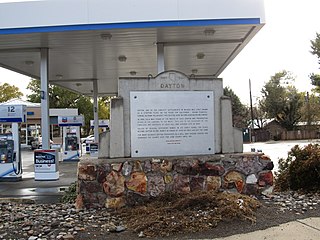
Dayton is an unincorporated community and census-designated place (CDP) in Lyon County, Nevada, United States. The population was 15,153 at the 2020 census. Dayton is the second oldest Nevada settlement. It is home to the oldest hotel in Nevada.

This is the Place Heritage Park is a Utah State Park that is located on the east side of Salt Lake City, Utah, United States, at the foot of the Wasatch Range and near the mouth of Emigration Canyon. A non-profit foundation manages the park.
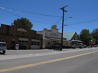
Genoa is an unincorporated town in Douglas County, Nevada, United States. Founded in 1851, it was the first settlement in what became the Nevada Territory. It is situated within Carson River Valley and is approximately 42 miles (68 km) south of Reno. The population was 939 at the 2010 census. It is home to the oldest bar in the state of Nevada which opened in 1853.

Valley of Fire State Park is a public recreation and nature preservation area covering nearly 46,000 acres (19,000 ha) located 16 miles (26 km) south of Overton, Nevada. The state park derives its name from red sandstone formations, the Aztec Sandstone, which formed from shifting sand dunes 150 million years ago. These features, which are the centerpiece of the park's attractions, often appear to be on fire when reflecting the sun's rays. It is Nevada's oldest state park, as commemorated with Nevada Historical Marker #150. It was designated as a National Natural Landmark in 1968.

Old Las Vegas Mormon Fort State Historic Park is a state park of Nevada, containing the Old Mormon Fort, the first structure built by people of European heritage in what would become Las Vegas fifty years later. In present-day Las Vegas, the site is at the southeast corner of Las Vegas Boulevard and Washington Avenue, less than one mile north of the downtown area and Fremont Street. This is the only U.S. state park located in a city that houses the first building ever built in that city. The fort was listed on the National Register of Historic Places on February 1, 1972. The site is memorialized with a tablet erected by the Church of Jesus Christ of Latter-day Saints in 1997, along with Nevada Historical Marker #35, and two markers placed by the Daughters of Utah Pioneers.

State Route 88 (SR 88), also known as the Carson Pass Highway, is a state highway in the U.S. state of California. It travels in an east–west direction from Stockton, in the San Joaquin Valley, to the Nevada state line, where it becomes Nevada State Route 88, eventually terminating at U.S. Route 395 (US 395). The highway is so named as it crests the Sierra Nevada at Carson Pass. The highway corridor predates the era of the automobile; the path over Carson pass was previously used for the California Trail and the Mormon Emigrant Trail. The mountainous portion of the route is included in the State Scenic Highway System.

Carson Pass is a mountain pass on the crest of the central Sierra Nevada, in the Eldorado National Forest and Alpine County, eastern California.

Lahontan State Recreation Area is a public recreation area surrounding Lake Lahontan, a 17-mile-long (27 km) impoundment of the Carson River, located approximately 18 miles (29 km) west of Fallon, Nevada. The reservoir features 69 miles (111 km) of shoreline and 11,200 acres (4,500 ha) of water when full. Much of the park lies below 4,000 feet (1,200 m) in elevation and is dominated by high desert sagebrush. Wooded areas of native cottonwoods and willow trees can be found along the shore of the lake. Primary access points to the park are along U.S. Route 50 near the Lahontan Dam and off U.S. Route 95 in the town of Silver Springs. A corridor known as Carson River Ranches connects Lahontan with Fort Churchill State Historic Park.

Echo Canyon State Park is a public recreation area located about twelve miles (19 km) east of the town of Pioche, Nevada, United States. The state park surrounds the seventy-acre (28 ha) Echo Canyon Reservoir. The scenic area around Echo Canyon has several ranches and farms. The park ranges in elevation from 5,200 feet (1,600 m) to 5,600 feet (1,700 m) and sees occasional winter snows.
Dayton State Park is a 152-acre (62 ha) public recreation area in the town of Dayton, Nevada, USA. The state park preserves the site of the Rock Point Stamp Mill, which was built in 1861 to process silver ore mined from the Comstock Lode.

Fort Churchill State Historic Park is a state park of Nevada, United States, preserving the remains of a United States Army fort and a waystation on the Pony Express and Central Overland Routes dating back to the 1860s. The site is one end of the historic Fort Churchill and Sand Springs Toll Road. The park is in Lyon County south of the town of Silver Springs, on U.S. Route 95 Alternate, eight miles (13 km) south of U.S. Route 50. Fort Churchill was designated a National Historic Landmark in 1961. A 1994 park addition forms a corridor along the Carson River.

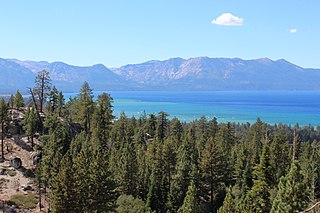
Lake Tahoe–Nevada State Park is a state park comprising multiple management units and public recreation areas on the northeast shores of Lake Tahoe in the U.S. state of Nevada. The park covers approximately 14,301 acres (5,787 ha). The Marlette Lake Water System, which is listed on the National Register of Historic Places and as a National Historic Civil Engineering Landmark, lies within park boundaries.

Ward Charcoal Ovens State Historic Park is an area designated for historic preservation and public recreation located 20 miles (32 km) south of the town of Ely in White Pine County, Nevada. The 700-acre (280 ha) state park protects beehive-shaped charcoal ovens constructed in the latter half of the 19th century.

Washoe Lake State Park is a year-round public recreation area occupying 3,775 acres (1,528 ha) on the southeast shore of Washoe Lake in Washoe County, Nevada. The state park lies to the east of Lake Tahoe, approximately five miles (8.0 km) north of Carson City near U.S. Route 395. The area around the park is known for its high winds making Washoe Lake a popular destination for windsurfers.

The Las Vegas Springs or Big Springs is the site of a natural oasis, known traditionally as a cienega. For more than 15,000 years, springs broke through the desert floor, creating grassy meadows. The bubbling springs were a source of water for Native Americans living here at least 5,000 years ago. Known as The Birthplace of Las Vegas it sustained travelers of the Old Spanish Trail and Mormons who came to settle the West. The springs' source is the Las Vegas aquifer.
The Nevada Department of Conservation and Natural Resources (DCNR) is a Nevada state agency that focuses on the preservation and management of Nevada’s natural, cultural, and recreational resources. The current director is James Settelmeyer. The agency is headquartered in Carson City, Nevada. One of its holdings is the South Fork Dam and Reservoir near Elko, Nevada.

Eagle Valley is the area encompassing Carson City, Nevada. The valley was first settled during the California Gold Rush of 1849. The discovery of Nevada's Comstock Lode in 1859 established the economic importance of the area, which would become the site of the Nevada State Capitol.
Van Sickle Bi-State Park is a public recreation area straddling the border of California and Nevada, United States, that overlooks Lake Tahoe and preserves the memory of Henry Van Sickle, a key member in the founding of Genoa and the surrounding area. The state park features trails for hiking, mountain biking, and horseback riding. It is managed by the Nevada Division of State Parks in partnership with the California Tahoe Conservancy.


