
Clark County is a county located in the U.S. state of Nevada. As of the 2020 census, the population was 2,265,461. Most of the county population resides in the Las Vegas Census County Divisions, which hold 2,196,623 people as of the 2020 Census, across 435 square miles (1,130 km2). It is by far the most populous county in Nevada, and the 11th most populous county in the United States. It covers 7% of the state's land area but holds 73% of the state's population, making Nevada the most centralized state in the United States.

The Mojave Desert is a desert in the rain shadow of the southern Sierra Nevada mountains and Transverse Ranges in the Southwestern United States. It is named for the indigenous Mojave people. It is located primarily in southeastern California and southwestern Nevada, with small portions extending into Arizona and Utah.

Lake Mead is a reservoir formed by Hoover Dam on the Colorado River in the Southwestern United States. It is located in the states of Nevada and Arizona, 24 mi (39 km) east of Las Vegas. It is the largest reservoir in the US in terms of water capacity. Lake Mead provides water to the states of Arizona, California, and Nevada as well as some of Mexico, providing sustenance to nearly 20 million people and large areas of farmland.
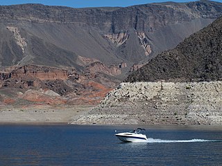
Lake Mead National Recreation Area is a U.S. national recreation area in southeastern Nevada and northwestern Arizona. Operated by the National Park Service, Lake Mead NRA follows the Colorado River corridor from the westernmost boundary of Grand Canyon National Park to just north of the cities of Laughlin, Nevada and Bullhead City, Arizona. It includes all of the eponymous Lake Mead as well as the smaller Lake Mohave – reservoirs on the river created by Hoover Dam and Davis Dam, respectively – and the surrounding desert terrain and wilderness.

The Las Vegas Valley is a major metropolitan area in the southern part of the U.S. state of Nevada, and the second largest in the Southwestern United States. The state's largest urban agglomeration, the Las Vegas Metropolitan Statistical Area is coextensive since 2003 with Clark County, Nevada. The Valley is largely defined by the Las Vegas Valley landform, a 600 sq mi (1,600 km2) basin area surrounded by mountains to the north, south, east and west of the metropolitan area. The Valley is home to the three largest incorporated cities in Nevada: Las Vegas, Henderson and North Las Vegas. Eleven unincorporated towns governed by the Clark County government are part of the Las Vegas Township and constitute the largest community in the state of Nevada.

The Spring Mountains are a mountain range of Southern Nevada in the United States, running generally northwest–southeast along the west side of Las Vegas and south to the border with California. Most land in the mountains is owned by the United States Forest Service and the Bureau of Land Management and managed as the Spring Mountains National Recreation Area within the Humboldt-Toiyabe National Forest and the Red Rock Canyon National Conservation Area.

The Black Canyon of the Colorado is the canyon on the Colorado River where Hoover Dam was built. The canyon is located on the Colorado River at the state line between Nevada and Arizona. The western wall of the gorge is in the El Dorado Mountains, and the eastern wall is in the Black Mountains of Arizona. The canyon formed about 15 million years ago during the Miocene Basin and Range uplift. Black Canyon gets its name from the black volcanic rocks that are found throughout the area.

Spirit Mountain, also known as Avi Kwa Ame is a mountain within the Lake Mead National Recreation Area near Laughlin, Nevada. It is listed on the United States National Register of Historic Places as a sacred place to Native American tribes in Southern Nevada. Spirit Mountain is the highest point in the Spirit Mountain Wilderness and is the highest point in the Newberry Mountains with the summit peak at 5,639 feet (1,719 m).

Grapevine Canyon is located in the Bridge Canyon Wilderness Area and the Spirit Mountain Wilderness within Lake Mead National Recreation Area. The canyon contains the Grapevine Canyon Petroglyphs and is accessible from Nevada State Route 163 which leads to Lower Grapevine Canyon Road. During non-drought years, the canyon contains a fresh water spring. The spring provides water for shrubbery along its path.
The Black Mountains, a mid-Miocene formation, in Nevada are a series of rugged, arid rocky volcanic mountains ranging in elevations to 3310 ft. The range lies on the north shore of Lake Mead, at the southwest corner of the Overton Arm, about 25 mi south of Overton, Nevada.

The Muddy Mountains are a large mountain range in Clark County, Nevada.

Spirit Mountain Wilderness Area is a 33,518-acre (13,564 ha) wilderness area located in the Newberry Mountains in Clark County, Nevada, 10 miles (16 km) northwest of Laughlin. Spirit Mountain lies within the area. It is managed by the Bureau of Land Management and the National Park Service.
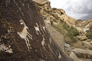
The Bridge Canyon Wilderness is a small wilderness area located in the Newberry Mountains in southern Nevada, United States, in the Lake Mead National Recreation Area. It is also within Avi Kwa Ame National Monument. The rock outcrops and caves make this area very striking. Stands of cottonwood trees can be found along the Grapevine Wash and Sacatone Wash water courses. Canyon grape, cattails and rushes grow in Grapevine Canyon. Discover the petroglyphs of early Native Americans in the canyon. Reptiles include the Western chuckwalla, side-blotched lizard, and Gila monster.

Further Future was a festival held in southern Nevada. The Further Future model was, “a shared experience that’s beyond our future,” and, "promises a carefully curated slate of, business and cultural leaders, chefs, mixologists and masseuses". Further Future catered to a techie club of invitation only exclusives in a controlled setting. Further Future's membership was 4000-5000 people and was structured around a corporate retreat setting. Further Future, located on the Moapa River Indian Reservation, claimed to offers an "all inclusive" festival experience, different than the, "vanish and leave no trace" principles instilled in those who participate in Burning Man. Further Future was the brainchild of a group called Robot Heart, an art and music collective known for the parties it throws during the annual Burning Man gathering in Northern Nevada's Black Rock Desert. The Further Future event aspired “to be a gathering of people with the common goal to spend time together celebrating the infinite possibilities of the future, without necessarily being shackled to the dictates of the past or the cycles of present-day society." The invitation-only festival for as many as 5,000 people ran from April 29 to May 1 in 2016 and 2017.
Pinto Valley is a basin in the Black Mountains of Clark County, Nevada. It lies at an elevation of 1,759 feet.

Muddy Mountains Wilderness Area is a 48,154-acre wilderness area, which is a part of the Muddy Mountains in Clark County, Nevada. The area is a part of the Lake Mead National Recreation Area.

Ireteba Peaks Wilderness is a 32,745 acre wilderness area spanning the area of the southern part of Eldorado Mountains to the northern parts of Lake Mohave. It is located 45 miles south of Las Vegas and was designated as a wilderness area in 2002. Iretaba Peaks Wilderness is managed by the National Park Service and the Bureau of Land Management. The western (BLM) portion of the wilderness is part of Avi Kwa Ame National Monument, designated in 2023.
Nellis Wash Wilderness is a 16,423 acre wilderness area located on the eastern side of the Newberry Mountains and extends eastward towards Lake Mohave. It shares a border with the Spirit Mountain Wilderness on its southern point. Nellis Wash Wilderness was designated as a wilderness area in 2002 and is managed by the National Park Service in Lake Mead National Recreation Area. It is also within Avi Kwa Ame National Monument.
Jumbo Springs Wilderness is a 4,631 acre wilderness area located in Southern Nevada. Located 50 miles east of Las Vegas, the site connects to both the southern and eastern sides of Lake Mead. Jumbo Springs Wilderness was designated as a wilderness area in 2002 and is under the management of the Bureau of Land Management.
