
Clark County is located in the U.S. state of Nevada. As of the 2010 census, the population was 1,951,269, with an estimated population of 2,266,715 in 2019. Most of the county population resides in the Las Vegas Census County Divisions, which hold 1,771,945 people as of the 2010 Census, across 476 square miles (1,233 km2). It is by far the most populous county in Nevada, and the 11th most populous county in the United States. It covers 7% of the state's land area but holds 74% of the state's population, making Nevada one of the most centralized states in the United States.

Mohave County is in the northwestern corner of the U.S. state of Arizona. As of the 2010 census, its population was 200,186. The county seat is Kingman, and the largest city is Lake Havasu City. It is the fifth largest county in the United States.
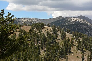
The Mount Charleston Wilderness Area is located west of Las Vegas in the southern part of the state of Nevada in the western United States. It was created by the U.S. Congress in 1989 under the provisions allowed by the Wilderness Act of 1964, and is managed by both the Bureau of Land Management and the U.S. Forest Service.

Calico Mountains Wilderness is a U S Wilderness Area in Nevada under the Bureau of Land Management. It is located in the Calico Hills.
The Black Rock Desert–High Rock Canyon Emigrant Trails National Conservation Area is the federal land in northwestern Nevada, under the Bureau of Land Management-BLM management and protection, and the ten Wilderness Areas within it.

Weepah Spring Wilderness is a 51,480-acre (20,830 ha) wilderness area in Lincoln and Nye Counties, in the U.S. state of Nevada. The Wilderness lies approximately 35 miles (56 km) north of the town of Alamo and is administered by the U.S. Bureau of Land Management.

Government Peak Wilderness is a 6,313-acre (2,555 ha) wilderness area in the northern part of the Snake Range of White Pine County, in the U.S. state of Nevada. Located approximately 55 miles (89 km) north of the town of Baker, the Wilderness was designated in 2006 and is administered by the U.S. Bureau of Land Management.
Highland Ridge Wilderness is a 68,627-acre (27,772 ha) wilderness area in the southern part of the Snake Range of White Pine County, just south of Great Basin National Park, in the U.S. state of Nevada. Located approximately 20 miles (32 km) south of the town of Baker, the Wilderness was designated in 2006 and is administered by the U.S. Bureau of Land Management.
Bright Star Wilderness is a 8,190-acre (3,314 ha) wilderness area in Kern County in the U.S. state of California.
The Kiavah Wilderness is a federally designated wilderness area located in the Mojave Desert, Scodie Mountains, and southern Sierra Nevada in Kern County, California, United States. California State Route 178 connects the town of Lake Isabella to State Highway 14 in the east, crossing Walker Pass at the north boundary of the wilderness.

The Sacatar Trail Wilderness is a federally designated wilderness area located 20 miles (32 km) northwest of Ridgecrest, California USA. It was created in 1994 with the passage of the California Desert Protection Act - Public Law 103-433 - and is managed by the Bureau of Land Management (BLM). The wilderness is 51,900 acres (210 km2) in size and protects portions of the southern Sierra Nevada Mountain Range.

The Worthington Mountains is a small 12 miles (19 km) long north-south trending mountain range in northwestern Lincoln County, Nevada. The range is bounded by the Sand Spring Valley to the west and Garden Valley to the east. The Quinn Canyon Range lies to the northwest, the Golden Gate Range lies to the east and the Timpahute Range lies to the south and southeast.
The Sylvania Mountains Wilderness is a federally designated wilderness area located 30 miles (48 km) east of Bishop in the state of California. The wilderness is 18,677acres in size and is managed by the Bureau of Land Management (BLM). The California Desert Protection Act of 1994 created the Sylvania Mountains Wilderness and was added to the National Wilderness Preservation System. The wilderness is bordered by Nevada stateline on the east, Piper Mountain Wilderness on the west and Death Valley National Park to the south.
The Chimney Peak Wilderness is a 13,134-acre (53.15 km2) wilderness area located 20 miles (32 km) northwest of Ridgecrest, in southeastern Tulare County, California.

The Trout Creek Mountains are a remote, semi-arid Great Basin mountain range mostly in southeastern Oregon and partially in northern Nevada in the United States. The range's highest point is Orevada View Benchmark, 8,506 feet (2,593 m) above sea level, in Nevada. Disaster Peak, elevation 7,781 feet (2,372 m), is another prominent summit in the Nevada portion of the mountains.

Spirit Mountain Wilderness Area is a 33,518-acre (13,564 ha) wilderness area located in the Newberry Mountains in Clark County, Nevada, 10 miles (16 km) northwest of Laughlin. Spirit Mountain lies within the area. It is managed by the Bureau of Land Management and the National Park Service.
The Stateline Wilderness is a wilderness area located in San Bernardino County, California, approximately three miles northwest of Primm, Nevada and I-15. Having an area of approximately 7,004 acres (2,834 ha), it contains the eastern terminus of the 15-mile-long (24 km) Clark Mountain Range.

Elizabeth von Till Warren was an American historian and preservationist. She had expertise in the history of water development in the Mojave Desert and the Las Vegas Valley in particular. She also had expertise in the historical route of the Old Spanish Trail in Southern Nevada.

Little Finland is a scenic red rock area, located in a remote section of Clark County, Nevada south of Mesquite, known for its red rock scenery and strangely-shaped, delicate rock formations. The landscape is similar to Valley of Fire State Park, which is about 20 miles (32 km) to the west, across Lake Mead. The rock formations are composed of red Aztec Sandstone, fossil sand dunes. Many of the features are small erosional fins, hence the name.

Ireteba Peaks Wilderness is a 32,745 acre wilderness area spanning the area of the southern part of Eldorado Mountains to the northern parts of Lake Mohave. It is located 45 miles south of Las Vegas and was designated as a wilderness area in 2002. Iretaba Peaks Wilderness is managed by the National Park Service and the Bureau of Land Management.
