Bowerston, Ohio

Last updated

Bowerston, Ohio
Bowerston Public Library.jpg
Bowerston Public Library
OHMap-doton-Bowerston.png
Location of Bowerston, Ohio
Map of Harrison County Ohio Highlighting Bowerston Village.png
Location of Bowerston in Harrison County
Coordinates: 40°25′38″N81°11′15″W / 40.42722°N 81.18750°W / 40.42722; -81.18750
Country United States
State Ohio
County Harrison
Area
[1]
  Total0.51 sq mi (1.31 km2)
  Land0.51 sq mi (1.31 km2)
  Water0.00 sq mi (0.00 km2)
Elevation
[2]
932 ft (284 m)
Population
 (2020)
  Total356
  Estimate 
(2023) [3]
349
  Density703.56/sq mi (271.43/km2)
Time zone UTC-5 (Eastern (EST))
  Summer (DST) UTC-4 (EDT)
ZIP code
44695
Area code 740
FIPS code 39-07916 [4]
GNIS feature ID2398156 [2]

Bowerston is a village in Harrison County, Ohio, United States. The population was 356 at the 2020 census.

Contents

History

The village of Bowerston was settled in the early 19th century by Barnhard Bower and his brother John. When they first moved to the area, two mills were already built on the south side of Conotton Creek. One mill was a sawmill, the other a gristmill, and in 1804, the Bower brothers began to rebuild the mills. In 1816, the settlement called Bower's Mills was laid out and later it was called Bowersville and finally Bowerston. Bowerston was platted by David Bower, Henry Hoover, and Nathaniel Bower on August 21, 1851, and was filed in court August 2, 1852. [5] The village was incorporated April 2, 1883.

Geography

According to the United States Census Bureau, the village has a total area of 0.51 square miles (1.32 km2), all land. [6]

Demographics

Historical population
CensusPop.Note
1880 320
1900 526
1910 514−2.3%
1920 500−2.7%
1930 440−12.0%
1940 4471.6%
1950 52216.8%
1960 463−11.3%
1970 4793.5%
1980 4871.7%
1990 343−29.6%
2000 41420.7%
2010 398−3.9%
2020 356−10.6%
2023 (est.)349 [3] −2.0%
U.S. Decennial Census [7]

2010 census

As of the census [8] of 2010, there were 398 people, 156 households, and 92 families living in the village. The population density was 780.4 inhabitants per square mile (301.3/km2). There were 179 housing units at an average density of 351.0 per square mile (135.5/km2). The racial makeup of the village was 98.7% White, 0.8% African American, 0.3% Native American, and 0.3% from two or more races.

There were 156 households, of which 30.8% had children under the age of 18 living with them, 42.9% were married couples living together, 9.0% had a female householder with no husband present, 7.1% had a male householder with no wife present, and 41.0% were non-families. 37.8% of all households were made up of individuals, and 17.3% had someone living alone who was 65 years of age or older. The average household size was 2.26 and the average family size was 2.99.

The median age in the village was 41.1 years. 22.6% of residents were under the age of 18; 4.5% were between the ages of 18 and 24; 28.9% were from 25 to 44; 23.1% were from 45 to 64; and 20.9% were 65 years of age or older. The gender makeup of the village was 45.0% male and 55.0% female.

2000 census

As of the census [4] of 2000, there were 414 people, 145 households, and 100 families living in the village. The population density was 816.9 inhabitants per square mile (315.4/km2). There were 165 housing units at an average density of 325.6 per square mile (125.7/km2). The racial makeup of the village was 100.00% White.

There were 145 households, out of which 35.2% had children under the age of 18 living with them, 53.1% were married couples living together, 12.4% had a female householder with no husband present, and 31.0% were non-families. 27.6% of all households were made up of individuals, and 11.7% had someone living alone who was 65 years of age or older. The average household size was 2.50 and the average family size was 3.06.

In the village, the population was spread out, with 24.2% under the age of 18, 9.2% from 18 to 24, 23.9% from 25 to 44, 19.8% from 45 to 64, and 22.9% who were 65 years of age or older. The median age was 39 years. For every 100 females there were 84.8 males. For every 100 females age 18 and over, there were 80.5 males.

The median income for a household in the village was $35,000, and the median income for a family was $42,083. Males had a median income of $28,036 versus $16,932 for females. The per capita income for the village was $15,267. About 1.9% of families and 6.5% of the population were below the poverty line, including 5.3% of those under age 18 and 12.2% of those age 65 or over.

The Conotton Creek Trail begins in Bowerston, as pictured in 2006 Conotton Creek Trail Mile 0.jpg
The Conotton Creek Trail begins in Bowerston, as pictured in 2006

Arts and culture

Bowerston is the beginning of the multi-use rails-to-trails path, the Conotton Creek Trail, along Conotton Creek. The trail is 11.4 miles (18.3 kilometers) long. It starts at the eastern end of Bowerston, at the southeast end of Erie Street. It is paved and suitable for bicycling, roller blading, wheel chairing and walking.

Education

Public education in the village of Bowerston is provided by the Conotton Valley Union Local School District. Campuses serving the village include Bowerston Elementary School (Grades K-6) and Conotton Valley High School [9] (Grades 7–12).

The village has a lending library, the Bowerston Public Library. [10]

Related Research Articles

<span class="mw-page-title-main">Harrison County, Ohio</span> County in Ohio, United States

Harrison County is a county located in the U.S. state of Ohio. As of the 2020 census, the population was 14,483, making it the fifth-least populous county in Ohio. Its county seat and largest village is Cadiz. The county is named for General William Henry Harrison, who was later President of the United States.

<span class="mw-page-title-main">West Union, Ohio</span> Village in Ohio, United States

West Union is a village in Adams County, Ohio, United States, about 55 miles (89 km) southeast of Cincinnati. The population was 3,004 at the 2020 census. It is the county seat of Adams County. West Union is served by West Union High School, the Adams County/Ohio Valley School District, and the West Union Public Library, a branch of the Adams County Public Library.

<span class="mw-page-title-main">Orwell, Ohio</span> Village in Ohio, United States

Orwell is a village in Ashtabula County, Ohio, United States. The population was 1,533 at the 2020 census.

<span class="mw-page-title-main">Belmont, Ohio</span> Village in Ohio, United States

Belmont is a village in central Belmont County, Ohio, United States. The population was 414 at the 2020 census. It is part of the Wheeling metropolitan area.

<span class="mw-page-title-main">Leesville, Ohio</span> Village in Ohio, United States

Leesville is a village in southwestern Carroll County, Ohio, United States. The population was 127 at the 2020 census. It is part of the Canton–Massillon metropolitan area.

<span class="mw-page-title-main">Sherrodsville, Ohio</span> Village in Ohio, United States

Sherrodsville is a village in southwestern Carroll County, Ohio, United States. The population was 222 at the 2020 census. It is part of the Canton–Massillon metropolitan area.

<span class="mw-page-title-main">Vinton, Ohio</span> Village in Ohio, United States

Vinton is a village in Gallia County, Ohio, United States. The population was 224 at the 2020 census. It is part of the rural Point Pleasant micropolitan area.

<span class="mw-page-title-main">Addyston, Ohio</span> Village in Ohio, United States

Addyston is a village in Miami Township, Hamilton County, Ohio, United States. Located along the Ohio River, it is a western suburb of the neighboring city of Cincinnati. The population was 927 at the 2020 census.

<span class="mw-page-title-main">Jewett, Ohio</span> Village in Ohio, United States

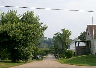
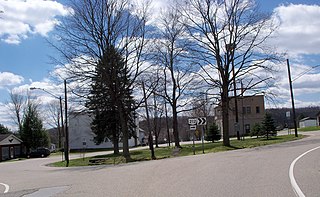
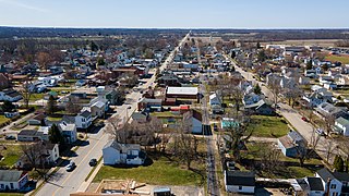
Jewett is a village in Harrison County, Ohio, United States. The population was 554 at the 2020 census.

<span class="mw-page-title-main">Scio, Ohio</span> Village in Ohio, United States

Scio is a village in northern Harrison County, Ohio, United States. The population was 673 at the 2020 census.

<span class="mw-page-title-main">Tarlton, Ohio</span> Village in Ohio, United States

Tarlton is a village in Fairfield and Pickaway counties in the U.S. state of Ohio. The population was 254 at the 2020 census.

<span class="mw-page-title-main">West Alexandria, Ohio</span> Village in Ohio, United States

West Alexandria is a village in Preble County, Ohio, United States. The population was 1,334 at the 2020 census.

<span class="mw-page-title-main">Limaville, Ohio</span> Census-designated place in Ohio, United States

Limaville is a census-designated place (CDP) and former village in Stark County, Ohio, United States. The population was 151 at the 2020 census. It is part of the Canton–Massillon Metropolitan Statistical Area.

<span class="mw-page-title-main">Hamden, Ohio</span> Village in Ohio, United States

Hamden is a village in Vinton County, Ohio, United States. The population was 727 at the 2020 census.

<span class="mw-page-title-main">McArthur, Ohio</span> Village in Ohio, United States

McArthur is a village in and the county seat of Vinton County, Ohio, United States. It is located 27 miles (43 km) southeast of Chillicothe. The population was 1,783 at the 2020 census.

<span class="mw-page-title-main">Wilkesville, Ohio</span> Village in Ohio, United States

Wilkesville is a village in Vinton County, Ohio, United States. The population was 116 at the 2020 census.

<span class="mw-page-title-main">Zaleski, Ohio</span> Village in Ohio, United States

Zaleski is a village in Vinton County, Ohio, United States. The population was 230 at the 2020 census.

<span class="mw-page-title-main">Macksburg, Ohio</span> Village in Ohio, United States

Macksburg is a village in Washington County, Ohio, United States, along the West Fork of Duck Creek. The population was 120 at the 2020 census. The village is about 28 miles (45 km) south of Cambridge, Ohio.

<span class="mw-page-title-main">Buchtel, Ohio</span> Village in Ohio, United States

Buchtel is a village in Athens and Hocking counties in the U.S. state of Ohio, just northeast of Nelsonville. Located in the Hocking Valley, it was a center of coal mining in the late 19th and early 20th centuries. The population was 518 at the 2020 census. A former name for the village is Bessemer.

<span class="mw-page-title-main">Adena, Ohio</span> Village in Ohio, United States

Adena is a village in southwestern Jefferson and southeastern Harrison counties in the U.S. state of Ohio. The population was 664 at the 2020 census. It is part of the Weirton–Steubenville metropolitan area.

References

  1. "ArcGIS REST Services Directory". United States Census Bureau. Retrieved September 20, 2022.
  2. 1 2 U.S. Geological Survey Geographic Names Information System: Bowerston, Ohio
  3. 1 2 "Annual Estimates of the Resident Population for Incorporated Places in Ohio: April 1, 2020 to July 1, 2023". United States Census Bureau. Retrieved June 4, 2024.
  4. 1 2 "U.S. Census website". United States Census Bureau . Retrieved January 31, 2008.
  5. Hanna, Charles Augustus (1900). Historical Collections of Harrison County, in the State of Ohio. Privately printed. p.  114.
  6. "US Gazetteer files 2010". United States Census Bureau. Archived from the original on January 25, 2012. Retrieved January 6, 2013.
  7. "Census of Population and Housing". Census.gov. Retrieved June 4, 2015.
  8. "U.S. Census website". United States Census Bureau . Retrieved January 6, 2013.
  9. "Conotton Valley High School". Conotton Valley Union Local Schools. Retrieved February 25, 2018.
  10. "Libraries". Harrison County, OH. Retrieved February 25, 2018.