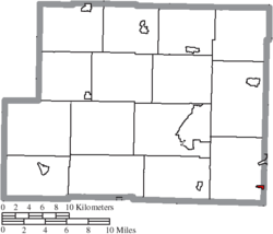
Ritchie County is a county in the U.S. state of West Virginia. As of the 2020 census, the population was 8,444. Its county seat is Harrisville. The county was created in 1843 by the Virginia General Assembly and named for Richmond newspaper publisher Thomas Ritchie.

Harrisville Township is a civil township of Alcona County in the U.S. state of Michigan. The population was 1,307 at the 2020 census. Harrisville Township surrounds the city of Harrisville, but the two are administered autonomously.

Lincoln is a village in Alcona County in the U.S. state of Michigan. The population was 305 at the 2020 census.

Harrisville is a town in Cheshire County, New Hampshire, United States. Besides the town center, it also includes the villages of Chesham and Eastview. The population of the town was 984 at the 2020 census.
Diana is a town in Lewis County, New York, United States. The population was 1,709 at the 2010 census. The town is on the northeastern border of the county and is located northeast of Watertown. The northwestern section of Diana is in the Fort Drum military reservation.
Harrisville is a hamlet and former village in Lewis County, New York, United States. The community is now a census-designated place. The population was 628 at the 2010 census.

New Alexandria is a village in eastern Jefferson County, Ohio, United States. The population was 232 at the 2020 census. It is part of the Weirton–Steubenville metropolitan area.
Smithfield was a village in Smithfield Township, Jefferson County, Ohio, United States. The population was 869 at the 2010 census. It is part of the Weirton–Steubenville, WV-OH Metropolitan Statistical Area. In 2019, Smithfield voted to dissolve itself.

Wintersville is a village in central Jefferson County, Ohio, United States. The population was 3,609 as of the 2020 Census. It is part of the Weirton–Steubenville metropolitan area. The village is suburban in nature and is governed by a mayor and council elected by non-partisan ballot.

Lodi is a village in Harrisville Township, Medina County, Ohio, United States. It is located southwest of the City of Medina along U.S. Route 42. As of the 2020 census, the population was 2,746.
Harrisville is a borough in Butler County, Pennsylvania, United States. The population was 897 at the 2010 census.

Mercer Township is a township in Butler County, Pennsylvania, United States. The population was 1,010 at the 2020 census.

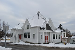
Harrisville is a census-designated place (CDP) and village in the town of Burrillville in Providence County, Rhode Island, United States. The population was 1,605 at the 2010 census. Much of the community composes a historic district listed on the National Register of Historic Places. The village was named after nineteenth century manufacturer Andrew Harris. Previously, the village was named Rhodesville, after Captain William Rhodes, an eighteenth century privateer.
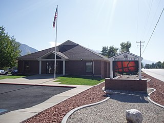
Harrisville is a city in Weber County, Utah, United States. The population was 5,567 at the 2010 census. It is part of the Ogden–Clearfield, Utah Metropolitan Statistical Area. The current mayor is Michelle Tait.

Windsor Heights is a village in Brooke County, West Virginia, United States. It is part of the Wheeling, West Virginia Metropolitan Statistical Area. The population was 423 at the 2010 census. Grace Davis was the mayor as of June 2017.

Harrisville is a town and the county seat of Ritchie County, West Virginia, United States. Harrisville is located at the junction of State Routes 31 and 16, five miles south of U.S. 50. Within the community are an elementary school, the county board of education, many businesses, three banks, a library, offices of the Ritchie Gazette and The Pennsboro News, a municipal park, and North Bend Golf Course. North Bend Lake and North Bend State Park are located just outside town limits. Municipal elections are held every two years.

Harris is a town located in Marquette County, Wisconsin. According to the 2000 census, the town had a total population of 729. The unincorporated community of Harrisville is located in the town. Both the community and the town were named for James Harris, who became the first postmaster when the community's post office opened in March 1851. The village of Westfield is adjacent to the town.

Wilson is a village in Belmont and Monroe counties in the U.S. state of Ohio. The population was 129 at the 2020 census. It is part of the Wheeling metropolitan area.

Verona is a village in Montgomery and Preble counties in the U.S. state of Ohio. The population was 403 at the 2020 census. It is part of the Dayton Metropolitan Statistical Area.

Lowell is a village in Dodge County, Wisconsin, United States, along the Beaver Dam River. The population was 340 at the 2010 census. The village is located within the Town of Lowell.