Jewett, Ohio

Last updated

Jewett, Ohio
OHMap-doton-Jewett.png
Location of Jewett, Ohio
Map of Harrison County Ohio Highlighting Jewett Village.png
Location of Jewett in Harrison County
Coordinates: 40°22′04″N81°00′05″W / 40.36778°N 81.00139°W / 40.36778; -81.00139
CountryUnited States
State Ohio
County Harrison
Area
[1]
  Total0.51 sq mi (1.32 km2)
  Land0.51 sq mi (1.32 km2)
  Water0.00 sq mi (0.00 km2)
Elevation
[2]
1,027 ft (313 m)
Population
 (2020)
  Total554
  Density1,088.41/sq mi (420.48/km2)
Time zone UTC-5 (Eastern (EST))
  Summer (DST) UTC-4 (EDT)
ZIP code
43986
Area code 740
FIPS code 39-39172 [3]
GNIS feature ID2398302 [2]

Jewett is a village in Harrison County, Ohio, United States. The population was 554 at the 2020 census.

Contents

History

Jewett was originally called Fairview, [4] and under the latter name was platted in 1851. [5] The present name is for T. M. Jewett, a railroad official. [6]

Jewett was the original home of the Jewett Car Company, a street car manufacturer, from 1894 until 1904. The street cars produced by this factory were shipped throughout the United States. The Jewett Car Company relocated to Newark, Ohio in 1904, and ceased operations in 1919.

Geography

Rolling farm land just outside Jewett, Ohio. Jewett County Farmland.jpg
Rolling farm land just outside Jewett, Ohio.

According to the United States Census Bureau, the village has a total area of 0.51 square miles (1.32 km2), all land. [7]

Jewett is the endpoint of the Conotton Creek Trail, an 11.4-mile (18.3 km) long multi-use rails-to-trails path along the Conotton Creek. It is paved and suitable for bicycling, non-electric scootering, roller blading, wheel chairing, walking, running, and jogging.

Demographics

Historical population
CensusPop.Note
1900 743
1910 91723.4%
1920 852−7.1%
1930 8762.8%
1940 1,03117.7%
1950 1,019−1.2%
1960 925−9.2%
1970 901−2.6%
1980 9727.9%
1990 778−20.0%
2000 7840.8%
2010 692−11.7%
2020 554−19.9%
U.S. Decennial Census [8]

2010 census

As of the census [9] of 2010, there were 692 people, 273 households, and 188 families living in the village. The population density was 1,356.9 inhabitants per square mile (523.9/km2). There were 317 housing units at an average density of 621.6 per square mile (240.0/km2). The racial makeup of the village was 96.7% White, 0.3% African American, 0.1% from other races, and 2.9% from two or more races. Hispanic or Latino of any race were 0.1% of the population.

There were 273 households, 33.7% of which had children under the age of 18 living with them, 50.2% were married couples living together, 11.7% had a female householder with no husband present, 7.0% had a male householder with no wife present, and 31.1% were non-families. 26.0% of all households were made up of individuals, and 11.7% had someone living alone who was 65 years of age or older. The average household size was 2.53 and the average family size was 2.96.

The median age in the village was 36.9 years. 25.6% of residents were under the age of 18; 9.1% were between the ages of 18 and 24; 26.4% were from 25 to 44; 23.9% were from 45 to 64; and 14.9% were 65 years of age or older. The gender makeup of the village was 50.6% male and 49.4% female.

2000 census

As of the census [3] of 2000, there were 784 people, 300 households, and 219 families living in the village. The population density was 1,532.2 inhabitants per square mile (591.6/km2). There were 327 housing units at an average density of 639.1 per square mile (246.8/km2). The racial makeup of the village was 98.60% White, 0.26% Native American, and 1.15% from two or more races. Hispanic or Latino of any race were 0.13% of the population.

There were 300 households, 34.7% of which had children under the age of 18 living with them, 55.7% were married couples living together, 13.0% had a female householder with no husband present, and 26.7% were non-families. 24.3% of all households were made up of individuals, and 12.7% had someone living alone who was 65 years of age or older. The average household size was 2.61 and the average family size was 3.05.

The population in the village was spread out, with 28.6% under the age of 18, 7.3% from 18 to 24, 26.7% from 25 to 44, 21.7% from 45 to 64, and 15.8% who were 65 years of age or older. The median age was 36 years. For every 100 females there were 92.6 males. For every 100 females aged 18 and over, there were 87.3 males.

The median income for a household in the village was $27,125, and the median income for a family was $29,297. Males had a median income of $30,313 versus $16,333 for females. The per capita income for the village was $12,158. About 15.8% of families and 21.7% of the population were below the poverty line, including 37.6% of those under age 18 and 4.1% of 65+ residents.

Related Research Articles

<span class="mw-page-title-main">Harrison County, Ohio</span> County in Ohio, United States

Harrison County is a county located in the U.S. state of Ohio. As of the 2020 census, the population was 14,483, making it the fifth-least populous county in Ohio. Its county seat and largest village is Cadiz. The county is named for General William Henry Harrison, who was later President of the United States.

<span class="mw-page-title-main">Elida, Ohio</span> Village in Ohio, United States

Elida is a village in Allen County, Ohio, United States. The population was 1,923 at the 2020 census. It is included in the Lima, Ohio Metropolitan Statistical Area.

<span class="mw-page-title-main">Buckland, Ohio</span> Village in Ohio, United States

Buckland is a village in Auglaize County, Ohio, United States. The population was 233 at the 2020 census. It is included in the Wapakoneta, Ohio Micropolitan Statistical Area. The village is served by the Wapakoneta City School District.

<span class="mw-page-title-main">Powhatan Point, Ohio</span> Village in Ohio, United States

Powhatan Point is a village in southeastern Belmont County, Ohio, United States, along the Ohio River. The population was 1,461 at the 2020 census. It is part of the Wheeling metropolitan area.

<span class="mw-page-title-main">Leesville, Ohio</span> Village in Ohio, United States

Leesville is a village in southwestern Carroll County, Ohio, United States. The population was 127 at the 2020 census. It is part of the Canton–Massillon metropolitan area.

<span class="mw-page-title-main">Sherrodsville, Ohio</span> Village in Ohio, United States

Sherrodsville is a village in southwestern Carroll County, Ohio, United States. The population was 222 at the 2020 census. It is part of the Canton–Massillon metropolitan area.

<span class="mw-page-title-main">Highland Hills, Ohio</span> Village in Ohio, United States

Highland Hills is a village in Cuyahoga County, Ohio, United States. The population was 662 at the 2020 census. A suburb of Cleveland, it was formally incorporated in 1990.

<span class="mw-page-title-main">Rossburg, Ohio</span> Village in Ohio, United States

Rossburg is a village in Darke County, Ohio, United States. The population was 159 at the 2020 census.

<span class="mw-page-title-main">Addyston, Ohio</span> Village in Ohio, United States

Addyston is a village in Miami Township, Hamilton County, Ohio, United States. Located along the Ohio River, it is a western suburb of the neighboring city of Cincinnati. The population was 927 at the 2020 census.

<span class="mw-page-title-main">Bowerston, Ohio</span> Village in Ohio, United States

Bowerston is a village in Harrison County, Ohio, United States. The population was 356 at the 2020 census.

<span class="mw-page-title-main">Hopedale, Ohio</span> Village in Ohio, United States

Hopedale is a village in Harrison County, Ohio, United States. The population was 920 at the 2020 census.

<span class="mw-page-title-main">Scio, Ohio</span> Village in Ohio, United States

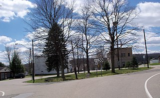
Scio is a village in northern Harrison County, Ohio, United States. The population was 673 at the 2020 census.

<span class="mw-page-title-main">Racine, Ohio</span> Village in Ohio, United States

Racine is a village in Meigs County, Ohio, United States, along the Ohio River. The population was 683 at the 2020 census.

<span class="mw-page-title-main">South Zanesville, Ohio</span> Village in Ohio, United States

South Zanesville is a village in Muskingum County, Ohio, United States, along the Muskingum River near the mouth of the Moxahala Creek. The population was 1,894 at the 2020 census. It is part of the Zanesville micropolitan area.

<span class="mw-page-title-main">Dupont, Ohio</span> Village in Ohio, United States

Dupont is a village in Putnam County, Ohio, United States. The population was 212 at the 2020 census.

<span class="mw-page-title-main">Limaville, Ohio</span> Census-designated place in Ohio, United States

Limaville is a census-designated place (CDP) and former village in Stark County, Ohio, United States. The population was 151 at the 2020 census. It is part of the Canton–Massillon Metropolitan Statistical Area.

<span class="mw-page-title-main">Hamden, Ohio</span> Village in Ohio, United States

Hamden is a village in Vinton County, Ohio, United States. The population was 727 at the 2020 census.

<span class="mw-page-title-main">Macksburg, Ohio</span> Village in Ohio, United States

Macksburg is a village in Washington County, Ohio, United States, along the West Fork of Duck Creek. The population was 120 at the 2020 census. The village is about 28 miles (45 km) south of Cambridge, Ohio.

<span class="mw-page-title-main">Walbridge, Ohio</span> Village in Ohio, United States

Walbridge is a village in Wood County, Ohio, United States, within the Toledo metropolitan area. The population was 3,011 at the 2020 census.

<span class="mw-page-title-main">Windsor Heights, West Virginia</span> Village in West Virginia, United States

Windsor Heights is a village in Brooke County, West Virginia, United States. It is part of the Wheeling, West Virginia Metropolitan Statistical Area. The population was 423 at the 2010 census. Grace Davis was the mayor as of June, 2017.

References

  1. "ArcGIS REST Services Directory". United States Census Bureau. Retrieved September 20, 2022.
  2. 1 2 U.S. Geological Survey Geographic Names Information System: Jewett, Ohio
  3. 1 2 "U.S. Census website". United States Census Bureau . Retrieved January 31, 2008.
  4. U.S. Geological Survey Geographic Names Information System: Jewett, Ohio
  5. Hanna, Charles Augustus (1900). Historical Collections of Harrison County, in the State of Ohio. Privately printed. p.  114.
  6. Gannett, Henry (1905). The Origin of Certain Place Names in the United States. Govt. Print. Off. pp.  169.
  7. "US Gazetteer files 2010". United States Census Bureau. Archived from the original on July 2, 2012. Retrieved January 6, 2013.
  8. "Census of Population and Housing". Census.gov. Retrieved June 4, 2015.
  9. "U.S. Census website". United States Census Bureau . Retrieved January 6, 2013.

Further reading