
Butler County is a county in the Commonwealth of Pennsylvania. It is part of Western Pennsylvania. As of the 2020 census, the population was 193,763. Its county seat is Butler. Butler County was created on March 12, 1800, from part of Allegheny County and named in honor of General Richard Butler, a hero of the American Revolution.

Butler Township is a township in Butler County, Pennsylvania, United States. The population was 17,230 at the 2020 census. The township was first settled by Europeans in 1795. It was established as a township in 1804 and as a first class township in 1922.

Boswell is a borough in Somerset County, Pennsylvania, United States. It is part of the Johnstown, Pennsylvania Metropolitan Statistical Area. The population was 1,221 at the 2020 census.

The Bettmann Archive is a collection of over 18 million photographs and images, some going back to the United States Civil War and including some of the best known U.S. historic images. The Archive also includes many images from Europe and elsewhere.

SubTropolis is a 55,000,000-square-foot (5,100,000 m2), 1,100-acre (4.5 km2) artificial cave in the bluffs above the Missouri River in Kansas City, Missouri, United States, that is claimed to be the world's largest underground storage facility. Developed by late Kansas City Chiefs owner Lamar Hunt via Hunt Midwest Real Estate Development, Inc., it has trademarked the phrase World's Largest Underground Business Complex.
Kettle Creek is a tributary of the West Branch Susquehanna River running through Tioga, Potter, and Clinton counties, in Pennsylvania. It is slightly less than 43 miles (69 km) long. Although many streams in the Kettle Creek watershed are considered "Class A Wild Trout streams" by the Pennsylvania Fish and Boat Commission, the lower reaches of the stream experience acid mine drainage. The upper reaches of the creek are considered to be very high-quality.

Shamokin Creek is a tributary of the Susquehanna River in Northumberland County, Pennsylvania, in the United States. It is approximately 32.4 miles (52.1 km) long and flows through Mount Carmel, Mount Carmel Township, Coal Township, Shamokin, Ralpho Township, Shamokin Township, Snydertown, Upper Augusta Township, and Sunbury. The watershed of the creek has an area of 137 square miles (350 km2). It experiences significant impacts by abandoned mine drainage and many abandoned mine drainage discharges are in its watershed. Various other impairments also affect parts of the creek's watershed. Shamokin Creek is in the Appalachian Mountains section of the Ridge and Valley physiographic province. Rock formations consisting of sandstone, shale, and anthracite deposits occur in the watershed.

The Maryland Mining Company is a historic coal mining, iron producer and railroad company that operated in Allegany County, Maryland, United States.
Hilliards is an unincorporated village that is located in Washington Township, Butler County, Pennsylvania, United States.
Iron Mountain Inc. is an American enterprise information management services company founded in 1951 and headquartered in Boston, Massachusetts. Its records management, information destruction, and data backup and recovery services are supplied to more than 220,000 customers in 58 countries throughout North America, Europe, Latin America, Africa, Asia, and Australia. As of 2020 over 94% of Fortune 1000 companies use Iron Mountain's services to store and manage their information in some capacity.

Mahanoy Creek is a 51.6-mile-long (83.0 km) tributary of the Susquehanna River in Northumberland and Schuylkill counties, Pennsylvania. There are at least 35 sources of acid mine drainage in the creek's watershed. Anthracite was mined in the upper part of the Mahanoy Creek watershed in the 19th and 20th centuries. Mahanoy Creek's tributaries include Schwaben Creek, Zerbe Run, Little Mahanoy Creek, Shenandoah Creek, and North Mahanoy Creek. Little Mahanoy Creek and Schwaben Creek are two streams in the watershed that are unaffected by acid mine drainage. Schwaben Creek has a higher number and diversity of fish species than the main stem.

Rose Point is an unincorporated community in east central Slippery Rock Township, Lawrence County, Pennsylvania, United States, very close to the Butler County line. Founded approximately 200 years ago, the community lies in a rural yet formerly industrial region of fields and broken terrain.

The National Mine Map Repository (NMMR) is part of the United States Department of the Interior (DOI), Office of Surface Mining Reclamation and Enforcement. The NMMR resides in the Pittsburgh suburb of Green Tree, Pennsylvania, and collects and maintains mine map information and images for the entire country, including data and maps of coal mines in the anthracite coal region of northeastern Pennsylvania. The Green Tree facility provides and stores, digitally and in microfilm, over 182,000 maps of abandoned mines. This repository contains maps of mine workings from the 1790s to the present day. It serves as a point of reference for mine maps and other information for both surface and underground mines throughout the United States. It also serves as a location to retrieve mine maps in an emergency. The NMMR provides services ranging from retrieving mine related data for economic analysis to assessing the potential risk associated with underground mining. Through analysis of mine maps and related information, the repository assists private and public sectors in industrial and commercial development, highway construction, and the preservation of public health, safety, and welfare. In addition, they collect, reproduce, and maintain a national inventory of mine maps and supporting documentation for private and public interests.

Little Nescopeck Creek is a tributary of Nescopeck Creek in Luzerne County, Pennsylvania, in the United States. It is approximately 8.5 miles (13.7 km) long and flows through Butler Township, Sugarloaf Township, and Conyngham. The watershed of the creek has an area of 14.0 square miles (36 km2). The creek is acidic and receives mine water from the Jeddo Tunnel. The main rock formation in the watershed is the Mauch Chunk Formation. However, the Pottsville Formation also appears in some areas. Soil series in the drainage basin include the Arnot Series, the Basher Series, and various other soil types.
Drury Run is a tributary of the West Branch Susquehanna River in Clinton County, Pennsylvania, in the United States. It is 7.71 miles (12.41 km) long and its watershed is 11.5 square miles in area, most of which is forest. The stream's tributaries are affected by acid mine drainage, as are the lower reaches of the stream itself. It begins in Tamarack Swamp and flows through Leidy Township, Noyes Township, and Renovo. Brook trout, brown trout, creek chub, and eastern blacknose dace all inhabit the stream.
Newport Creek is a tributary of the Susquehanna River in Luzerne County, Pennsylvania, in the United States. It is 4.9 miles (7.9 km) in length. Named tributaries of the creek include South Branch Newport Creek. The entire watershed of Newport Creek is considered by the Pennsylvania Department of Environmental Protection to be impaired.

Nanticoke Creek is a tributary of the Susquehanna River in Luzerne County, Pennsylvania, in the United States. It is approximately 4.4 miles (7.1 km) long and flows through Hanover Township and Nanticoke. The watershed of the creek has an area of 7.57 square miles (19.6 km2). The creek has one named tributary, which is known as Espy Run. Nanticoke Creek impaired by pH and metals due to abandoned mine drainage. Abandoned mine drainage discharges in the creek's watershed include the Truesdale Mine Discharge and the Askam Borehole. The creek is located in the Northern Middle Anthracite Field and is in the Anthracite Valley Section of the ridge and valley physiographic province. The main rock formations in the watershed include the Mauch Chunk Formation, the Pottsville Group, and the Llewellyn Formation. The surficial geology consists of coal dumps, surface mining land, alluvium, Wisconsinan Outwash, Wisconsinan Till, urban land, and bedrock.
The Askam Borehole is a borehole that is located in Luzerne County, Pennsylvania, in the United States. It is situated in the watershed of Nanticoke Creek north of PA 29 and Dundee Road and contributes several million gallons of acid mine drainage to that creek daily. The borehole also discharges large loads of iron and other substances. It was constructed by the Pennsylvania Department of Environmental Protection in the early 1970s and drains mine water from the South-East Mine Pool Complex. The discharges of the borehole have been treated by active treatment systems and artificial wetlands.
Rausch Creek is a tributary of Pine Creek in Schuylkill County, Pennsylvania, in the United States. It is approximately 1.7 miles (2.7 km) long and flows through Hegins Township. The watershed of the creek has an area of 9.55 square miles (24.7 km2). The creek has two named tributaries: East Branch Rausch Creek and West Branch Rausch Creek. Rausch Creek is designated as an impaired waterbody, with the cause of the impairment being metals and the probable source being abandoned mine drainage.
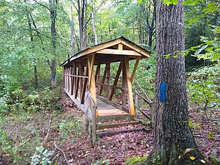
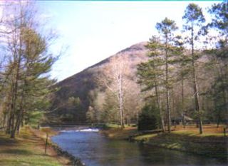
The Terrace Mountain Trail is a 25.9-mile (41.7 km) linear hiking trail in south-central Pennsylvania, United States, which is mostly parallel to the shore of Raystown Lake. The trail is open to both hiking and mountain biking. The trail is maintained by the US Army Corps of Engineers as part of its management of the Raystown Lake complex. After the development of Raystown Dam and the artificial lake in 1973, the western flank of Terrace Mountain alongside the lake became part of a protected area mostly owned by the federal government, interspersed with some tracts of Pennsylvania's Rothrock State Forest and Trough Creek State Park. The Terrace Mountain Trail visits all these areas.


