Brewster, Washington

Last updated

Brewster
City of Brewster
Brewster2.jpg
The outskirts of Brewster
Okanogan County Washington Incorporated and Unincorporated areas Brewster Highlighted.svg
Location of Brewster, Washington
Coordinates: 48°5′55″N119°46′54″W / 48.09861°N 119.78167°W / 48.09861; -119.78167
Country United States
State Washington
County Okanogan
Government
  MayorArt Smyth [1]
Area
[2]
  Total1.51 sq mi (3.90 km2)
  Land1.15 sq mi (2.98 km2)
  Water0.35 sq mi (0.92 km2)
Elevation
814 ft (248 m)
Population
 (2020)
  Total1,983
  Density1,300/sq mi (510/km2)
Time zone UTC-8 (Pacific (PST))
  Summer (DST) UTC-7 (PDT)
ZIP code
98812
Area code 509
FIPS code 53-07835
GNIS feature ID1516938 [3]
Website City of Brewster

Brewster is a city in Okanogan County, Washington, United States. The population was 1,983 at the 2020 census.

Contents

History

Brewster was founded in 1896. [4] A post office called Brewster has been in operation since 1898. [5] The city derives its name from John Bruster, a pioneer settler. [6]

Geography

Brewster is located on the confluence of the Okanogan and Columbia Rivers.

According to the United States Census Bureau, the city has a total area of 1.19 square miles (3.08 km2), all of it land. [7] The 30–bed Three Rivers Hospital serves the city as the largest hospital in the county. The radio telescope located in Brewster is the northernmost of ten dishes comprising the Very Long Baseline Array.

Demographics

Historical population
CensusPop.Note
1910 296
1920 39433.1%
1930 4134.8%
1940 4478.2%
1950 85190.4%
1960 94010.5%
1970 1,05912.7%
1980 1,33726.3%
1990 1,63322.1%
2000 2,18934.0%
2010 2,3708.3%
2020 1,983−16.3%
U.S. Decennial Census [8]
2020 Census [9]
An aerial view of Brewster, adjacent to the Columbia River. Columbia River - Brewster, Washington aerial 01A.jpg
An aerial view of Brewster, adjacent to the Columbia River.

2010 census

As of the 2010 census, [10] there were 2,370 people, 699 households, and 535 families living in the city. The population density was 1,991.6 inhabitants per square mile (769.0/km2). There were 730 housing units at an average density of 613.4 per square mile (236.8/km2). The racial makeup of the city was 50.8% White, 0.3% African American, 2.2% Native American, 0.2% Asian, 43.0% from other races, and 3.5% from two or more races. Hispanic or Latino of any race were 73.0% of the population.

There were 699 households, of which 54.5% had children under the age of 18 living with them, 52.9% were married couples living together, 15.6% had a female householder with no husband present, 8.0% had a male householder with no wife present, and 23.5% were non-families. 20.5% of all households were made up of individuals, and 10% had someone living alone who was 65 years of age or older. The average household size was 3.31 and the average family size was 3.81.

The median age in the city was 27.6 years. 35.1% of residents were under the age of 18; 11.1% were between the ages of 18 and 24; 26.4% were from 25 to 44; 17.2% were from 45 to 64; and 10% were 65 years of age or older. The gender makeup of the city was 50.4% male and 49.6% female. For population 25 years and older, 50.2% have a high school diploma or higher, 8.1% have a bachelor's degree or higher, and 3.4% have a graduate or professional degree.

2000 census

As of the 2000 census, there were 2,189 people, 662 households, and 485 families living in the city. The population density was 1,828.0 people per square mile (704.3/km2). There were 739 housing units at an average density of 617.1 per square mile (237.8/km2). The racial makeup of the city was 54.91% White, 0.37% African American, 2.28% Native American, 0.27% Asian, 38.78% from other races, and 3.38% from two or more races. Hispanic or Latino of any race were 59.5% of the population.

There were 662 households, out of which 49.2% had children under the age of 18 living with them, 53.3% were married couples living together, 13.6% had a female householder with no husband present, and 26.6% were non-families. 23.4% of all households were made up of individuals, and 14.8% had someone living alone who was 65 years of age or older. The average household size was 3.23 and the average family size was 3.80.

In the city, the population was spread out, with 35.3% under the age of 18, 11.7% from 18 to 24, 26.7% from 25 to 44, 14.6% from 45 to 64, and 11.7% who were 65 years of age or older. The median age was 27 years. For every 100 females, there were 93.0 males. For every 100 females age 18 and over, there were 90.2 males.

The median income for a household in the city was $21,556, and the median income for a family was $22,381. Males had a median income of $15,652 versus $16,154 for females. The per capita income for the city was $9,555. About 29.1% of families and 31.7% of the population were below the poverty line, including 38.0% of those under age 18 and 16.4% of those age 65 or over.

Climate

Climate data for Brewster, Washington
MonthJanFebMarAprMayJunJulAugSepOctNovDecYear
Record high °F (°C)57
(14)
64
(18)
78
(26)
93
(34)
103
(39)
108
(42)
110
(43)
110
(43)
103
(39)
86
(30)
75
(24)
59
(15)
110
(43)
Mean daily maximum °F (°C)35
(2)
42
(6)
55
(13)
65
(18)
74
(23)
81
(27)
90
(32)
90
(32)
80
(27)
63
(17)
45
(7)
34
(1)
63
(17)
Mean daily minimum °F (°C)23
(−5)
26
(−3)
32
(0)
38
(3)
45
(7)
52
(11)
58
(14)
57
(14)
48
(9)
37
(3)
30
(−1)
22
(−6)
39
(4)
Record low °F (°C)−19
(−28)
−19
(−28)
2
(−17)
19
(−7)
26
(−3)
33
(1)
35
(2)
35
(2)
29
(−2)
10
(−12)
−9
(−23)
−19
(−28)
−19
(−28)
Average precipitation inches (mm)1.38
(35)
1.09
(28)
0.90
(23)
0.55
(14)
0.96
(24)
0.90
(23)
0.56
(14)
0.26
(6.6)
0.39
(9.9)
0.60
(15)
1.43
(36)
1.86
(47)
10.88
(275.5)
Source: [11]

Related Research Articles

<span class="mw-page-title-main">Okanogan County, Washington</span> County in Washington, United States

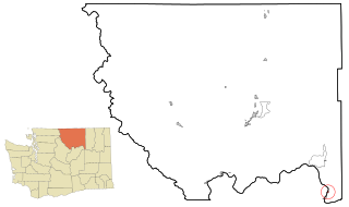
Okanogan County is a county located in the U.S. state of Washington along the Canada–U.S. border. As of the 2020 census, the population was 42,104. The county seat is Okanogan, while the largest city is Omak. Its area is the largest in the state.

<span class="mw-page-title-main">Ferry County, Washington</span> County in Washington, United States

Ferry County is a county located on the northern border of the U.S. state of Washington. As of the 2020 census, the population was 7,178, making it the fourth-least populous county in Washington. The county seat and largest city is Republic. The county was created out of Stevens County in February 1899 and is named for Elisha P. Ferry, the state's first governor.

<span class="mw-page-title-main">Douglas County, Washington</span> County in Washington, United States

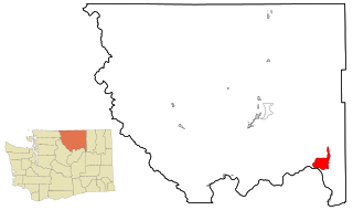
Douglas County is a county located in the U.S. state of Washington. As of the 2020 census, its population was 42,938. The county seat is Waterville, while its largest settlement is East Wenatchee. The county was created out of Lincoln County on November 28, 1883 and is named for American statesman Stephen A. Douglas.

<span class="mw-page-title-main">Chelan County, Washington</span> County in Washington, United States

Chelan County is a county in the U.S. state of Washington. As of the 2020 census, its population was 79,074. The county seat and largest city is Wenatchee. The county was created out of Okanogan and Kittitas Counties on March 13, 1899. It derives its name from a Chelan Indian word meaning "deep water," likely a reference to 55-mile (89 km)-long Lake Chelan, which reaches a maximum depth of 1,486 feet (453 m).

<span class="mw-page-title-main">Brewster, Kansas</span> City in Thomas County, Kansas

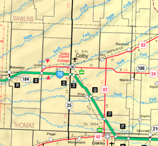
Brewster is a city in Thomas County, Kansas, United States. As of the 2020 census, the population of the city was 291.

<span class="mw-page-title-main">Brewster, Minnesota</span> City in Minnesota, United States

Brewster is a city in Nobles County, Minnesota, United States. The population was 473 at the 2010 census.

<span class="mw-page-title-main">Fort Calhoun, Nebraska</span> City in Washington County, Nebraska, United States

Fort Calhoun is a city in Washington County, Nebraska, United States. The population was 1,108 at the 2020 census. The city includes Fort Atkinson, the first fort built west of the Missouri River.

<span class="mw-page-title-main">Brewster, Ohio</span> Village in Ohio, United States

Brewster is a village in southwestern Stark County, Ohio, United States. The population was 2,113 at the 2020 census. It is part of the Canton–Massillon metropolitan area.

<span class="mw-page-title-main">Bridgeport, Washington</span> City in Washington, United States

Bridgeport is a city in Douglas County, Washington. It is part of the Wenatchee−East Wenatchee Metropolitan Statistical Area. Bridgeport's population was 2,141 at the 2020 census. Bridgeport is located near the Chief Joseph Dam.

<span class="mw-page-title-main">Conconully, Washington</span> Town in Washington, United States

Conconully is a town in Okanogan County, Washington, United States. The population was 193 at the 2020 census.

<span class="mw-page-title-main">Elmer City, Washington</span> Town in Washington, United States

Elmer City is a town in Okanogan County, Washington, United States. The population was 239 at the 2020 census.

<span class="mw-page-title-main">Nespelem, Washington</span> Town in Washington, United States

Nespelem is a town in Okanogan County, Washington, United States. The population was 180 at the 2020 census. The town is located on the Colville Indian Reservation. The name Nespelem is derived from a local Native American term meaning "large flat meadow".

<span class="mw-page-title-main">Nespelem Community, Washington</span> CDP in Washington, United States

Nespelem Community is a census-designated place (CDP) in Okanogan County, Washington, United States. The population was 283 at the 2020 census.

<span class="mw-page-title-main">North Omak, Washington</span> CDP in Washington, United States

North Omak is a census-designated place (CDP) in Okanogan County, Washington, United States, north of Omak, Washington. The community is considered to be part of Greater Omak, and had a population of 651 at the 2020 census.

<span class="mw-page-title-main">Okanogan, Washington</span> City in Washington, United States

Okanogan is a city in Okanogan County, Washington, United States. The population was 2,379 at the 2020 census, down from 2,552 at the 2010 census, within the Greater Omak Area. It is the seat of Okanogan County.

<span class="mw-page-title-main">Oroville, Washington</span> City in Washington, United States

Oroville is a city located in the northern bulk of the Okanogan Highlands in north-central Washington, United States. Oroville is a member municipality of Okanogan County, Washington, situated between Omak and Penticton. The population was 1,795 at the 2020 census.

<span class="mw-page-title-main">Pateros, Washington</span> City in Washington, United States

Paterospə-TARR-əs is a city in Okanogan County, Washington, United States. The population at the 2020 census was 593.

<span class="mw-page-title-main">Riverside, Washington</span> Town in Washington, United States

Riverside is a town in Okanogan County, Washington, United States. The population was 280 at the 2010 census, and increased to 329 at the 2020 census.

<span class="mw-page-title-main">Tonasket, Washington</span> City in Washington, United States

Tonasket is a city in Okanogan County, Washington, United States. The population was 1,103 at the 2020 census.

<span class="mw-page-title-main">Coulee Dam, Washington</span> Town in Washington, United States

Coulee Dam is a town in Douglas, Grant, and Okanogan counties in the state of Washington. The Douglas County portion of Coulee Dam is part of the Wenatchee–East Wenatchee Metropolitan Statistical Area. The population was 1,211 as of the 2020 census.

References

  1. "City Officials: Brewster". Municipal Research and Services Center . Retrieved February 16, 2022.
  2. "2019 U.S. Gazetteer Files". United States Census Bureau. Retrieved August 7, 2020.
  3. "Brewster". Geographic Names Information System . United States Geological Survey, United States Department of the Interior.
  4. Meany, Edmond S. (1923). Origin of Washington geographic names. Seattle: University of Washington Press. p. 27.
  5. "Okanogan County". Jim Forte Postal History. Archived from the original on March 4, 2016. Retrieved May 20, 2015.
  6. "Unusual names, odd spellings found in Washington". The Spokesman-Review. December 24, 1977. pp. A12. Retrieved May 20, 2015.
  7. "US Gazetteer files 2010". United States Census Bureau. Archived from the original on January 25, 2012. Retrieved December 19, 2012.
  8. United States Census Bureau. "Census of Population and Housing" . Retrieved October 4, 2013.
  9. "Census Bureau profile: Brewster, Washington". United States Census Bureau. May 2023. Retrieved May 12, 2024.
  10. "U.S. Census website". United States Census Bureau . Retrieved December 19, 2012.
  11. "weather.com" . Retrieved November 15, 2011.