Elmer City, Washington

Last updated
Elmer City
Elmer City, Washington
Okanogan County Washington Incorporated and Unincorporated areas Elmer City Highlighted.svg
Location of Elmer City, Washington
Coordinates: 47°59′54″N118°57′13″W / 47.99833°N 118.95361°W / 47.99833; -118.95361 Coordinates: 47°59′54″N118°57′13″W / 47.99833°N 118.95361°W / 47.99833; -118.95361
CountryUnited States
State Washington
County Okanogan
Area
[1]
  Total0.27 sq mi (0.70 km2)
  Land0.24 sq mi (0.62 km2)
  Water0.03 sq mi (0.09 km2)
Elevation
1,096 ft (334 m)
Population
 (2010) [2]
  Total238
  Estimate 
(2019) [3]
248
  Density1,042.02/sq mi (402.68/km2)
Time zone UTC-8 (Pacific (PST))
  Summer (DST) UTC-7 (PDT)
ZIP code
99124
Area code(s) 509
FIPS code 53-21485 [4]
GNIS feature ID1512189 [5]

Elmer City is a town in Okanogan County, Washington, United States. The population was 238 at the 2010 census.

Contents

History

Elmer City was officially incorporated on April 17, 1947, and is located on the Colville Indian Reservation.

Geography

Elmer City is located at 47°59′54″N118°57′13″W / 47.99833°N 118.95361°W / 47.99833; -118.95361 (47.998309, -118.953486). [6]

According to the United States Census Bureau, the town has a total area of 0.21 square miles (0.54 km2), all of it land. [7]

Demographics

Historical population
CensusPop.
1950 513
1960 265−48.3%
1970 32422.3%
1980 312−3.7%
1990 290−7.1%
2000 267−7.9%
2010 238−10.9%
2019 (est.)248 [3] 4.2%
U.S. Decennial Census [8]
2018 Estimate [9]

2010 census

At the 2010 census, [2] there were 238 people, 99 households and 64 families living in the town. The population density was 1,133.3 inhabitants per square mile (437.6/km2). There were 112 housing units at an average density of 533.3 per square mile (205.9/km2). The racial makeup of the town was 47.9% White, 0.8% African American, 28.6% Native American, 2.1% Asian, 2.1% from other races, and 18.5% from two or more races. Hispanic or Latino of any race were 3.4% of the population.

There were 99 households, of which 24.2% had children under the age of 18 living with them, 44.4% were married couples living together, 14.1% had a female householder with no husband present, 6.1% had a male householder with no wife present, and 35.4% were non-families. 28.3% of all households were made up of individuals, and 10.2% had someone living alone who was 65 years of age or older. The average household size was 2.40 and the average family size was 2.92.

The median age in the town was 47.8 years. 18.5% of residents were under the age of 18; 9.6% were between the ages of 18 and 24; 18.8% were from 25 to 44; 29.9% were from 45 to 64; and 23.1% were 65 years of age or older. The gender makeup of the town was 48.3% male and 51.7% female.

2000 census

At the 2000 census, [4] there were 267 people, 110 households and 70 families living in the town. The population density was 1,291.7 per square mile (490.9/km2). There were 127 housing units at an average density of 614.4 per square mile (233.5/km2). The racial makeup of the town was 54.31% White, 1.50% African American, 35.96% Native American, 0.37% Asian, 3.00% from other races, and 4.87% from two or more races. Hispanic or Latino of any race were 4.87% of the population.

There were 110 households, of which 23.6% had children under the age of 18 living with them, 47.3% were married couples living together, 13.6% had a female householder with no husband present, and 35.5% were non-families. 33.6% of all households were made up of individuals, and 10.0% had someone living alone who was 65 years of age or older. The average household size was 2.43 and the average family size was 3.06.

25.8% of the population were under the age of 18, 5.2% from 18 to 24, 23.2% from 25 to 44, 30.7% from 45 to 64, and 15.0% who were 65 years of age or older. The median age was 43 years. For every 100 females, there were 103.8 males. For every 100 females age 18 and over, there were 98.0 males.

The median household income was $32,500 and the median family income was $38,000. Males had a median income of $40,000 vand females $23,438. The per capita income was $16,366. About 11.4% of families and 18.6% of the population were below the poverty line, including 26.8% of those under the age of eighteen and 19.6% of those 65 or over.

Related Research Articles

Sherwood Manor, Connecticut Census-designated place in Connecticut, United States

Sherwood Manor is a census-designated place (CDP) within the town of Enfield in Hartford County, Connecticut, United States. The population was 5,410 at the 2010 census.

Edgewood, Indiana Town in Indiana, United States

Edgewood is a town in Anderson Township, Madison County, Indiana, United States. It is part of the Anderson, Indiana Metropolitan Statistical Area. The population was 1,913 at the 2010 census.

Winn, Maine Town in Maine, United States

Winn is a town in Penobscot County, Maine, United States, on the east bank of the Penobscot River. The town was named for John M. Winn, an early landholder. The population was 407 at the 2010 census.

Cutler, Maine Town in Maine, United States

Cutler is a town in Washington County, Maine, United States. The town was named after Joseph Cutler, an early settler, who hailed from Newburyport, Massachusetts. The population was 507 at the 2010 census.

Roque Bluffs, Maine Town in Maine, United States

Roque Bluffs is a town in Washington County, Maine, United States. The population was 303 at the 2010 census. The town is home to Roque Bluffs State Park.

Elmer, Missouri City in Missouri, United States

Elmer is a city in Macon County, Missouri, United States. The population was 80 at the 2010 census.

Ravenwood, Missouri City in Missouri, United States

Ravenwood is a city in Nodaway County, Missouri, United States, near the Platte River. The population was 440 at the 2010 census, at which time it was a town.

Benton Ridge, Ohio Village in Ohio, United States

Benton Ridge is a village in Hancock County, Ohio, United States. The population was 299 at the 2010 census. It is within the boundaries of the Liberty-Benton Local School district.

Corrigan, Texas Town in Texas, United States

Corrigan is a town in Polk County, Texas in the United States of America. The town was named for Pat Corrigan, conductor on the first train on the newly built Houston, East and West Texas Railway to arrive in the town. The population was 1,595 at the 2010 census.

Waterville, Washington Town in Washington, United States

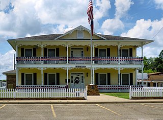
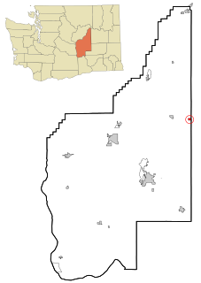
Waterville is a town in and the county seat of Douglas County, Washington, United States which is known for its wheat industry. It is part of the Wenatchee-East Wenatchee metropolitan area. The population was 1,138 at the 2010 census.

Marlin, Washington Town in Washington, United States

Marlin—officially the Town of Krupp—is a town in Grant County, Washington, United States. The population was 48 at the 2010 census. Although legally incorporated as Krupp, the town is more commonly known as Marlin, which is the name of its post office. Elections are held there under the name of Marlin, Washington, and they are the same locale.

Nespelem, Washington Town in Washington, United States

Nespelem is a town in Okanogan County, Washington, United States. The population was 236 at the 2010 census. The town is located on the Colville Indian Reservation. The name Nespelem is derived from a local Indian term meaning "large flat meadow".

Waitsburg, Washington City in Washington, United States

Waitsburg is a city in Walla Walla County, Washington, United States. The population was 1,217 at the 2010 census. Waitsburg has a unique city classification in Washington state, being the state's only city which still operates under its territorial charter.

Henderson, West Virginia Town in West Virginia, United States

Henderson is a town in Mason County, West Virginia, United States, at the confluence of the Ohio and Kanawha Rivers. The population was 271 at the 2010 census. It is part of the Point Pleasant, WV–OH Micropolitan Statistical Area. The town was incorporated in 1893 and named for Samuel Bruce Henderson, who owned the townsite at the time.

Anawalt, West Virginia Town in West Virginia, United States

Anawalt is a town in McDowell County, West Virginia, United States. At one time it was known as Jeanette. It is named in honor of James White Anawalt, who was then manager of Union Supply Company, a subsidiary of the United States Steel Company. The population was 226 at the 2010 census. Coal mining was the town's chief industry.

Brandonville, West Virginia Town in West Virginia, United States

Brandonville is a town in Preston County, West Virginia, United States. The population was 101 at the 2010 census.

Rock Elm, Wisconsin Town in Wisconsin, United States

Rock Elm is a town in Pierce County, Wisconsin, United States. The population was 504 at the 2000 census. The unincorporated communities of Exile and Rock Elm are located in the town. The unincorporated community of Waverly is also located partially in the town.

Coulee Dam, Washington Town in Washington, United States

Coulee Dam is a town in Douglas, Grant, and Okanogan counties in the State of Washington. The Douglas County portion of Coulee Dam is part of the Wenatchee–East Wenatchee Metropolitan Statistical Area. The population was 1,098 as of the 2010 census.

Baldwin is a town in St. Croix County, Wisconsin, United States. The population was 903 at the 2000 census. The Village of Baldwin is located partially within the town. The unincorporated community of Dahl is also located in the town.

Topsham (CDP), Maine CDP in Maine, United States

Topsham is a census-designated place (CDP) in the town of Topsham in Sagadahoc County, Maine, United States. The population was 6,271 at the 2000 census. It is part of the Portland–South Portland–Biddeford, Maine Metropolitan Statistical Area.

References

  1. "2019 U.S. Gazetteer Files". United States Census Bureau. Retrieved August 7, 2020.
  2. 1 2 "U.S. Census website". United States Census Bureau . Retrieved December 19, 2012.
  3. 1 2 "Population and Housing Unit Estimates". United States Census Bureau. May 24, 2020. Retrieved May 27, 2020.
  4. 1 2 "U.S. Census website". United States Census Bureau . Retrieved January 31, 2008.
  5. "Elmer City". Geographic Names Information System . United States Geological Survey.
  6. "US Gazetteer files: 2010, 2000, and 1990". United States Census Bureau. February 12, 2011. Retrieved April 23, 2011.
  7. "US Gazetteer files 2010". United States Census Bureau. Archived from the original on January 25, 2012. Retrieved December 19, 2012.
  8. United States Census Bureau. "Census of Population and Housing" . Retrieved September 25, 2014.
  9. "Population Estimates". United States Census Bureau . Retrieved October 8, 2019.