
Okanogan County is a county located in the U.S. state of Washington along the Canada–U.S. border. As of the 2020 census, the population was 42,104. The county seat is Okanogan, while the largest city is Omak. Its area is the largest in the state.

Dewey–Humboldt is a town in Yavapai County, Arizona, United States. The population of the town was 3,894 according to the 2010 census. The Dewey–Humboldt area was a census-designated place (CDP) at the 2000 census, at which time its population was 6,295.

Neihart is a town in Cascade County, Montana, United States. It is located in the center of Little Belt Mountains. The population was 43 at the 2020 census. It is part of the Great Falls, Montana, Metropolitan Statistical Area.

Kenmore is a city in King County, Washington, United States, along the northernmost shore of Lake Washington. It is a suburban commuter town at the mouth of the Sammamish River, 12 miles (19 km) northeast of downtown Seattle and 2 miles (3.2 km) west of Bothell. The population was 20,460 at the 2010 census. Kenmore Air Harbor is the largest seaplane-only passenger facility of its kind in the United States.

Carbonado is a town in Pierce County, Washington, United States. It is located near the Carbon River in the north of the county, approximately 50 miles (80 km) southeast of Seattle. Carbonado is the last town before entering Mount Rainier National Park and is also a popular spot for off-roading. The town also served as an important coal mining community in the late nineteenth and early twentieth centuries, when the town operated the largest coal mine in Pierce County. The population was 734 at the 2020 census.

Bothell is a city in King and Snohomish counties in the U.S. state of Washington. It is part of the Seattle metropolitan area, situated near the northeast end of Lake Washington. As of the 2020 census, it had a population of 48,161 residents.

Mazama is an unincorporated community in Okanogan County located in the Methow Valley of Washington, on the east slopes of the North Cascades and North Cascades National Park. It is located along the North Cascades Highway, 14 miles (23 km) northwest of Winthrop and about 28 miles (45 km) south of the Canada–United States border. Mazama's town center elevation is 2,106 feet (642 m), and it is located 2.7 miles (4.3 km) south of and 4,895 feet (1,492 m) below Goat Peak.

State Route 20 (SR 20), also known as the North Cascades Highway, is a state highway that traverses the U.S. state of Washington. It is the state's longest highway, traveling 436 miles (702 km) across the northern areas of Washington, from U.S. Route 101 (US 101) at Discovery Bay on the Olympic Peninsula to US 2 near the Idaho state border in Newport. The highway travels across Whidbey Island, North Cascades National Park, the Okanagan Highland, the Kettle River Range, and the Selkirk Mountains. SR 20 connects several major north–south state highways, including Interstate 5 (I-5) in Burlington, US 97 through the Okanogan–Omak area, SR 21 in Republic, and US 395 from Kettle Falls to Colville.
The Colorado Silver Boom was a dramatic expansionist period of silver mining activity in the U.S. state of Colorado in the late 19th century. The boom started in 1879 with the discovery of silver at Leadville. Over 82 million dollars worth of silver was mined during the period, making it the second great mineral boom in the state, and coming 20 years after the earlier and shorter Colorado Gold Rush of 1859. The boom was largely the consequence of large-scale purchases of silver by the United States Government authorized by Congress in 1878. The boom endured throughout the 1880s, resulting in an intense increase in both the population and wealth of Colorado, especially in the mountains. It came to an end in 1893 in the wake of the collapse of silver prices caused by the repeal of Sherman Silver Purchase Act.
Middlemount is a rural town and locality in the Isaac Region, Queensland, Australia. In the 2016 census the locality of Middlemount had a population of 1,841 people.

Cassilis is a ghost town in Gippsland, Victoria, Australia. It was named after a district and castle in Ayrshire, Scotland. In the late 19th century, at the peak of the gold boom, it was a thriving mining centre and home to more than 500 people.

Cleator, formerly Turkey Creek or Turkey, is a near ghost town and small community in Yavapai County, Arizona, in the Southwestern United States.

Methow, is an unincorporated community in Okanogan County, Washington, United States. The community had a population of 262 at the 2000 census.

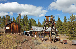
Bodie is a ghost town in Okanogan County, Washington, United States.
The Bodie Mine is an inactive, privately owned gold mine in Okanogan County, Washington, United States. It is located within a triangle formed by the town of Wauconda, Washington the original town of Bodie, Washington, and the later ghost town of Bodie, on Toroda Road.

Alamo Crossing is a ghost town in Mohave County, Arizona, United States. The town was settled in the late 1890s, in what was then the Arizona Territory. It served as a camp for mining prospectors in the manganese-rich Artillery Mountains, being the only town in the area. After 1918, the post office permanently closed, but the town was only intermittently abandoned, with its founders often present through until at least the mid-1950s. The town was intentionally flooded in 1968 to create Alamo Lake. In 2020, the area of Alamo was revived for mining again, this time for surface-level gold prospecting.

Packard is a ghost town in Whitley County, Kentucky, United States. Packard was located 7 miles (11 km) southeast of Williamsburg. It was founded as a mining camp by the Thomas B. Mahan family around 1900. Packard's population is thought to have reached at one point nearly 400 residents. The community was a coal town which served the Packard Coal Company; the community and the company were named after Whitley County school teacher Amelia Packard. Packard once had a railway station on the Louisville and Nashville Railroad as well as a post office, which opened on November 27, 1908.
Golden is a ghost town in Okanogan County, Washington, United States. Golden was a mining town which was founded around 1887. The discovery of gold in the area led to the creation of Golden. By 1892 more than thirty buildings were located between the mines and Wannacut Lake. The town was called Golden due to the promise continued gold in the area. Golden had a population of 300 in its heyday. The town had a general store, restaurant, saloon and post office along with other false fronted businesses. As the gold became depleted the town became more deserted. By 1910 under 100 people remained in Golden. The town eventually became a ghost town. The depression of the thirties brought some new inhabitants to Golden, but eventually it was deserted. Today little remains of the town.
Ruby is an American ghost town in Okanogan County, Washington State.

Colorado mining history is a chronology of precious metal mining, fuel extraction, building material quarrying, and rare earth mining.


