Bukit Merah

Last updated

Bukit Merah
Other transcription(s)
   English Redhill
   Chinese 红山
Hóngshān(Pinyin)
Âng-soaⁿ(Hokkien POJ)
   Malay Bukit Merah
   Tamil புக்கிட் மேரா
Singapore Harbourfront 2010.JPG
Tiong Bahru 9, Jul 06.JPG
Redhill town.jpg
SouthernRidges HendersonWaves.JPG
Labrador Park Jetty.jpg
From top left to right: HarbourFront, Singapore Improvement Trust flats in Tiong Bahru, Skyline of Redhill, Henderson Waves, Jetty at Labrador Nature Reserve
Bukit Merah in Central Region, Singapore.svg
Location in Central Region
Singapore location map (main island).svg
Red pog.svg
Bukit Merah
Location of Bukit Merah within Singapore
Coordinates: 1°16′54.86″N103°49′26.11″E / 1.2819056°N 103.8239194°E / 1.2819056; 103.8239194
CountryFlag of Singapore.svg  Singapore
Region Central Region
CDCs
Town councils
  • Jalan Besar Town Council
  • Tanjong Pagar Town Council
  • West Coast Town Council
Constituencies
Government
  MayorsCentral Singapore CDC

South West CDC


  Members of ParliamentJalan Besar GRC

Radin Mas SMC

Tanjong Pagar GRC

West Coast GRC

  • Rachel Ong
Area
  Total14.34 km2 (5.54 sq mi)
  Residential3.12 km2 (1.20 sq mi)
Population
 (2020) [1] [2] [3]
  Total151,250
  Density11,000/km2 (27,000/sq mi)
Ethnic groups
[4]
   Chinese 120,830
   Malays 11,430
   Indians 13,980
  Others5,010
Postal districts
2, 3, 4, 5, 9, 10
Dwelling units51,885
Projected ultimate68,000

Bukit Merah, also known as Redhill, is a planning area and new town situated in the southernmost part of the Central Region of Singapore. the planning area borders Tanglin to the north, Queenstown to the west and the Downtown Core, Outram and Singapore River planning areas of the Central Area to the east.

Contents

Bukit Merah shares a maritime boundary with the Southern Islands planning area located beyond its southernmost point. It is the most populated planning area in the Central Region, and the 12th most populated planning area in the country overall, being home to more than 150,000 residents. [5]

Etymology

Bukit Merah translates to “red hill” in Malay, and is a reference to the red-coloured lateritic soil found on the hill. According to the Sejarah Melayu , Singapore used to be plagued by swordfish attacking the people living in the coastal regions. A young boy named Hang Nadim proposed an ingenious solution, to build a wall of banana stems along the coast at the present location of Tanjong Pagar.

When the swordfish attacked, their snouts were stuck in the stems. With the swordfish problem solved, Hang Nadim earned great respect from the people, but also jealousy from the rulers. The fourth King of Singapura, Paduka Seri Maharaja, finally ordered his execution, and it was said that his blood-soaked the soil of the hill where he was killed, giving rise to the red-coloured hill. [6]

The hill was eventually trimmed to its current state in 1973, when it made way for Redhill Close and what would eventually become the now defunct Henderson Secondary School. During its existence, a Chinese cemetery was situated on the reverse side of this hill, which is today, the location of Tiong Bahru.

History

Keppel Harbour dates back to the 14th century when an ancient Chinese traveller, Wang Dayuan named the harbour as "Long-Ya-Men" or "Dragon Teeth Gate" after two rock outcrops located near Labrador Park, which resembled dragon's teeth. The two rock outcrops were subsequently blown up by the Straits Settlements Surveyor, John Thomson, in August 1848 to widen the entrance a new harbour.

With the earliest records of Bukit Merah's existence in the Malay Annals, the town had a huge role to play in the early maritime trade of the Kingdom of Singapura.

Mount Faber was once known as Telok Blangah Hill. Its name was changed to Mount Faber after Captain Edward Faber cut the road up to the top in 1845 to set up a signal station. The Singapore General Hospital site dates back to 1882. Labrador Nature Park was used as a defence outpost in the 19th century until World War II. [7]

The town's fertile red soil was employed to great effect, when it was a district rich in gambier cultivation during British colonial rule. [8]

Even before the industrialisation of Jurong, Bukit Merah already had a small head start in the emerging heavy industry market in Singapore. With the first brickwork factories and mills emerging in the precincts of Henderson Hill and Redhill as early as the 1930s. [9]

The town is also home to the first housing estate in the country, Tiong Bahru, which was developed by the Singapore Improvement Trust in the backdrop of a rapidly growing population in post-war Singapore. The estate later became the basis of what would eventually become the first new town in the Republic, Queenstown.

Geography

The Bukit Merah-Central Area boundary line along Outram Road as seen from Bukit Merah. Outram Road, Dec 05.JPG
The Bukit Merah–Central Area boundary line along Outram Road as seen from Bukit Merah.

According to the various master plans laid out by the Urban Redevelopment Authority, Bukit Merah is bounded by Alexandra Canal and the Singapore River to the north and HarbourFront and Keppel Bay to the south, Kim Seng Road, Outram Road and Cantonment Road to the east and Alexandra Road to the west. There are several subzones within the planning area, namely Alexandra, Bukit Ho Swee, Bukit Merah, City Terminals, Depot Road, Everton Park, HarbourFront, Henderson Hill, Redhill, Singapore General Hospital, Telok Blangah and Tiong Bahru.

Subzones

Name of subzonesLocationNotable structuresAccessibility
Alexandra Areas along Alexandra Road, Jalan Bukit Merah, Jalan Rumah Tinggi and Hoy Fatt RoadAlexandra Primary School, Alexandra Central, Alexandra Village, AIA Building and IKEA Alexandra Labrador Park MRT station, Redhill MRT station and buses
Bukit Ho Swee Areas along Jalan Bukit Ho Swee and DeltaBeo Crescent Market, Havelock Food Centre, Kim Seng Community Centre and Singapore Examinations and Assessment Board Tiong Bahru MRT station, Havelock MRT station and buses
Bukit MerahAreas along Bukit Merah CentralBukit Merah Town Centre, Bukit Merah Bus Interchange, Bukit Merah Polyclinic, Former HDB Centre, Bukit Merah Secondary School and Gan Eng Seng Primary SchoolBuses
City Terminals Pulau Brani and

areas near Keppel Harbour

Port of Singapore Keppel Terminal, Police Coast Guard Headquarters and St. James Power Station Keppel MRT Station (Future) and buses. Keppel Terminal is a restricted area
Depot Road Areas along Depot RoadCentral Manpower Base, Defence Science and Technology Agency, Depot Heights Shopping Centre, ISS International School and The Interlace Buses
Everton Park Areas bounded by Cantonment Road, Neil Road, Keppel RoadCantonment Primary School, Former Tanjong Pagar railway station, Kampong Bahru Bus Terminal and Police Cantonment Complex Cantonment MRT station (Future), Buses
HarbourFront Bukit Merah South HarbourFront Bus Interchange, HarbourFront Centre, Singapore Cruise Centre, VivoCity HarbourFront MRT station, Buses, Cable Car, Sentosa Express
Henderson HillBukit Merah WestBukit Merah West NPC, Delta Sports Complex, Gan Eng Seng School, Henderson Community Club and Tiong Bahru Park Buses
RedhillNorthwestern Bukit MerahRedhill Market and Food Centre, Leng Kee Community Centre and Enabling Village Redhill MRT station, Buses
Singapore General Hospital Bukit Merah EastDuke-NUS Graduate Medical School, Health Promotion Board, Health Sciences Authority, Outram Community Hospital & SingHealth Tower, Outram Polyclinic and Singapore General Hospital Outram Park MRT station, Buses
Telok Blangah Bukit Merah SouthBlangah Rise Primary School, CHIJ St. Theresa's Convent, Mount Faber Park, Radin Mas Community Club, Radin Mas Primary School, Tang Gah Beo Temple, SAFRA Mount Faber, Telok Blangah Community Club and Telok Blangah Hill Park Telok Blangah MRT station, Buses
Tiong Bahru Area bounded by Jalan Bukit Ho Swee, Outram Road, CTE, AYE and Lower Delta RoadTiong Bahru Community Centre, Tiong Bahru Market, Tiong Bahru Plaza and Zhangde Primary School Tiong Bahru MRT station, Buses

Transportation

Mass Rapid Transit

Outram Park MRT station was the first station to open in the planning area in 1987, followed by the namesake Redhill MRT station and Tiong Bahru MRT station in 1988. Today, there are currently 7 MRT stations that serve the planning area across 4 lines, the East West line, Circle line, North East line and the Thomson-East Coast line. HarbourFront MRT station is an interchange station between the North East line and the Circle line, which is also the current terminus for both lines. Outram Park MRT station was initially a double-line interchange station between the East West and North East lines but became a triple-line interchange station after the commencement of the third stage of the Thomson–East Coast line in 2022. The 7 stations are:

Future stations that are currently under construction include:

The future stations, Keppel and Cantonment will be located within the new town as part of Stage 6 of the Circle line that will be completed by 2026. [10]

Bus

There are two bus interchanges and one bus terminal in the new town. The Bukit Merah Bus Interchange, which serves Bukit Merah, is located at Bukit Merah Town Centre. Service Number 132 links the Interchange to Redhill MRT station while bus services 5, 16, and 851 links the interchange to Tiong Bahru MRT station. There are two feeder services originating from the interchange which serves the Telok Blangah estate. The HarbourFront Bus Interchange is located at the southern part of Bukit Merah, serving nearby amenities such as the HarbourFront Centre and VivoCity, the largest shopping mall in Singapore. The Kampong Bahru Bus Terminal is located along Spooner Road, near the vicinity of the Singapore General Hospital.

Education

Gan Eng Seng School is one of the oldest schools in Singapore. It is located along Henderson Road. GESS Henderson Road.jpg
Gan Eng Seng School is one of the oldest schools in Singapore. It is located along Henderson Road.

Primary schools

Secondary schools

Tertiary Institutions

Other schools

Amenities

Delta Sports Complex Delta Swimming Complex.JPG
Delta Sports Complex
The main facade of Tiong Bahru Plaza, after its refurbishment in 2016. Tiong Bahru Plaza refurbished.jpg
The main facade of Tiong Bahru Plaza, after its refurbishment in 2016.
Panoramic view of Bukit Merah, with the Central Area in the background, from Mount Faber. Singapore - panoramio (23).jpg
Panoramic view of Bukit Merah, with the Central Area in the background, from Mount Faber.

Places of Worship

Buddhist Temples

Chinese Temples

  • Ban Siew San Kuan Imm Temple (1880)
  • Giok Hong Tian Temple (1887)
  • Hock Teck Tong Temple (1932)
  • Kai San Temple (1904)
  • Kim Lan Beo Temple (1830, relocate in 1984)
  • Leng San Teng Temple (1879)
  • Koon Seng Ting Temple (1880)
  • Lei Yin Temple (1957)
  • Qi Tian Gong Temple (1920)
  • Qi Tian Tan Temple (1949)
  • Tai Yeong Kon Temple (1947)
  • Tang Gah Beo Temple
  • Telok Blangah Ting Kong Beo Temple (1923)

Chinese Clan Temples

  • Lim See Tai Chong Soo Kiu Leong Tong Temple
  • San Jiang Gong Ci Temple

Chinese Combined Temples

  • Chia Leng Kong Heng Kang Tian Temple
  • Chin Leng Keng (Leng San Teng, Chin Lin Keng & Ban Sian Beo)
  • Temple of Liang Hong Sze Kong Hock Keng Heap Hoe Keng

Churches

Hindu Temples

Mosques

Sikh Temples

  • Gurdwara Sahib Silat Road

Shopping Centres

Parks

Panoramic view of Bukit Merah, with the Central Area in the background, from Mount Faber. Singapore - panoramio (23).jpg
Panoramic view of Bukit Merah, with the Central Area in the background, from Mount Faber.

Community Centres/Clubs

Sports facilities

Politics

Bukit Merah belongs to six political divisions in four constituencies. A large portion of Bukit Merah is under Tanjong Pagar GRC with some areas under Jalan Besar GRC, Radin Mas SMC and West Coast GRC, served by the People's Action Party. As of the 2020 General election, the Members of Parliament for Tanjong Pagar GRC are Indranee Rajah for Tanjong Pagar-Tiong Bahru division, Joan Pereira for Henderson-Dawson division and Eric Chua for Queenstown division. Melvin Yong is the current Member of Parliament for Radin Mas SMC, Rachel Ong for Telok Blangah division of West Coast GRC and Josephine Teo for Kreta Ayer-Kim Seng division of Jalan Besar GRC. The planning area is overseen by three town councils, namely Tanjong Pagar Town Council (TPTC), West Coast Town Council (WCTC) and Jalan Besar Town Council (JBTC).

Bukit Merah is covered by two Community Development Councils (CDC), Central Singapore District and South West District. Denise Phua is the current mayor for Central CDC and Low Yen Ling is the current mayor for South West CDC.

See also

Related Research Articles

<span class="mw-page-title-main">Chinatown, Singapore</span> Neighborhood in Singapore, subzone of Outram

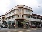
Chinatown is a subzone and ethnic enclave located within the Outram district in the Central Area of Singapore. Featuring distinctly Chinese cultural elements, Chinatown has had a historically concentrated ethnic Chinese population.

<span class="mw-page-title-main">Outram Park MRT station</span> Mass Rapid Transit station in Singapore

Outram Park MRT station is an underground Mass Rapid Transit (MRT) interchange station in Singapore. The station is on the East–West, North East and Thomson–East Coast lines, and located on the boundary of Bukit Merah and Outram planning areas, near the junction of Outram Road, Eu Tong Sen Street and New Bridge Road. It is the closest MRT station to Singapore General Hospital, the Police Cantonment Complex, Outram Community Hospital and the Health Promotion Board. Included in the early plans of the MRT network in 1982, it was constructed as part of the Phase I MRT segment from Novena, and was to be completed by December 1987. Following the opening of the Thomson–East Coast Line on 13 November 2022, Outram Park station became a triple-line interchange, joining the Marina Bay and Dhoby Ghaut stations.

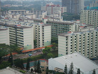
Tiong Bahru is a housing estate located within the Bukit Merah Planning Area, in the Central Region of Singapore. Tiong Bahru was constructed in the 1920s by the Singapore Improvement Trust, the predecessor to the Housing Development Board and an entity of the British colonial authority providing mass public housing in Singapore and is the oldest housing estate in Singapore. The main estate consists of 30 apartment blocks with over 900 units of two to five rooms that are also commonly referred to as "walk-ups". There are also high-rise Housing and Development Board (HDB) flats and condominiums along Boon Tiong Road, Jalan Membina and Kim Tian Road which surround the main estate.

<span class="mw-page-title-main">Tanjong Pagar</span> Historic district in Singapore

Tanjong Pagar is a historic district located within the Central Business District of Singapore, straddling the Outram Planning Area and the Downtown Core under the Urban Redevelopment Authority's urban planning zones. The district has a rich history and is known for its cultural and architectural landmarks, making it a popular tourist destination.

Telok Blangah is a subzone region and housing estate located in the area behind Keppel Harbour in Bukit Merah, Singapore. Teluk Blanga is the district between Pasir Panjang and Tanjong Pagar.

<span class="mw-page-title-main">Tiong Bahru MRT station</span> Mass Rapid Transit station in Singapore

Tiong Bahru MRT station is an underground Mass Rapid Transit (MRT) station on the East West line in Bukit Merah, Singapore. This is the first and last underground station for eastbound and westbound trains respectively.

<span class="mw-page-title-main">Redhill MRT station</span> Mass Rapid Transit station in Singapore

Redhill MRT station is an above-ground Mass Rapid Transit (MRT) station on the East West line (EWL) located in Bukit Merah, Singapore.

<span class="mw-page-title-main">Mount Faber</span> Place in Singapore

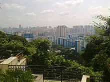
Mount Faber, formerly Telok Blangah Hill, is a hill about 94 metres (308 ft) in height, located in the town of Bukit Merah in the Central Region of Singapore. It overlooks the Telok Blangah area, and the western parts of the Central Area. The summit is accessible by Mount Faber Road or Mount Faber Loop via Morse Road, but there are many footpaths or trails leading up the hill. The main paths are: Marang Trail which leads from Marang Road at the Harbourfront MRT station and the Southern Ridges Park Connector which connects from Telok Blangah Hill Park, Kent Ridge Park and Henderson Waves.

<span class="mw-page-title-main">Tanjong Pagar Group Representation Constituency</span>

The Tanjong Pagar Group Representation Constituency is a five-member Group Representation Constituency (GRC) in Central and Western Singapore. The five divisions consists: Buona Vista, Queenstown, Moulmein-Cairnhill, Tanjong Pagar-Tiong Bahru and Henderson-Dawson. The current Members of Parliament are Chan Chun Sing, Joan Pereira, Alvin Tan, Eric Chua and Indranee Rajah from the People's Action Party (PAP).

Teban Gardens is a residential precinct located in Jurong East, Singapore. Immediately north of Pandan Reservoir, it comprises exclusively public housing built by the JTC Corporation and Housing and Development Board.

<span class="mw-page-title-main">Bukit Ho Swee</span> Subzone of Bukit Merah Planning Area in Central Region, Singapore

Bukit Ho Swee is a subzone within the planning area of Bukit Merah, Singapore, as defined by the Urban Redevelopment Authority (URA). Its boundary is made up of the Alexandra Canal in the north; Kim Seng Road and Outram Road in the east; Zion Road and Jalan Bukit Ho Swee in the south; Delta Road and Lower Delta Road in the west.

<span class="mw-page-title-main">Commonwealth, Singapore</span> Subzone of Queenstown Planning Area in Singapore

Commonwealth is a subzone of Queenstown, located in the central-western part of Singapore. It is named after the Commonwealth of Nations. Commonwealth consists of Housing and Development Board flats, and there is one primary school and a secondary school in the area, New Town Primary School and Queensway Secondary School. SBS Transit Bus Services 32, 51, 93, 100, 105, 111, 122, 123, 145, 147, 153, 186, 195, 196, 198, SMRT Buses Services 61, 961/961M & 970 and Tower Transit Singapore Service 855 passes through this area. The nearest Mass Rapid Transit station is Commonwealth MRT station. Amenities in the area include Blessed Sacrament Church, Faith Methodist Church, Masjid Mujahidin Mosque, Queenstown Community Centre, Queenstown Lutheran Church, Ridout Tea Garden, Shuang Long Shan Wu Shu Ancestral Hall, Sri Muneeswaran Temple and Tanglin Halt Food Centre and Market.

<span class="mw-page-title-main">Kim Seng Road</span> Place in Singapore

Kim Seng Road is a street in Singapore that runs along the upper-easternmost portion of the Bukit Merah-Central Area border. It was named after Peranakan philanthropist, Tan Kim Seng. Today, the boundaries of Kim Seng division are: Indus Road and Alexandra Canal in the north; Jalan Bukit Ho Swee in the south; Kim Seng Road and Outram Road in the east; and Lower Delta Road in the west.

Bukit Purmei is a small housing estate within Bukit Merah planning area in Singapore, near Telok Blangah estate. Bukit Purmei consists of 15 HDB blocks, private apartments and landed property.

library@harbourfront Public library in Singapore

References

  1. 1 2 City Population – statistics, maps and charts | Bukit Merah
  2. 1 2 HDB Key Statistics FY 2014/2015 Archived 4 March 2016 at the Wayback Machine
  3. "Statistics Singapore - Geographic Distribution - 2018 Latest Data" . Retrieved 11 February 2019.
  4. "Singapore Residents by Planning Area/Subzone, 2015". Singapore Department of Statistics. Archived from the original (XLS) on 10 June 2016. Retrieved 24 May 2016.
  5. "Statistics Singapore – Geographic Distribution". singstat.gov.sg. Archived from the original on 16 November 2016. Retrieved 6 June 2017.
  6. "Bukit Merah Town Centre". lostnfiledsg. Retrieved 9 November 2015.
  7. "Singapore Bukit Merah Map & Bukit Merah Singapore". streetdirectory.com. Retrieved 9 November 2015.
  8. "Singapore Infopedia – Bukit Merah". National Library Board.
  9. "ALEXANDRA BRICKWORKS". The Straits Times . 17 February 1931.
  10. "Three new stations to close loop on Circle Line". TODAYonline. Retrieved 13 March 2016.

Sources