Woodlands is a planning area and residential town located in the North of Singapore. As of 2019, the town has a population of 254,733. Located approximately 25 km (16 mi) north of the central business district (CBD), it is the densest planning area and is the regional centre for the northern parts of the country.

Choa Chu Kang, alternatively spelled Chua Chu Kang and often abbreviated as CCK, is a planning area and residential town located at the northwestern point of the West Region of Singapore. The town shares borders with Sungei Kadut to the north, Tengah to the southwest, Bukit Batok to the southeast, Bukit Panjang to the east and the Western Water Catchment to the west. Choa Chu Kang New Town is separated into two portions by the Kranji Expressway.

The Bukit Panjang LRT is a 8-kilometre (5.0 mi) automated guideway transit line in Bukit Panjang, Singapore. The BPLRT is currently the only LRT line operated by SMRT Trains. As the name suggests, it serves 13 stations in the neighbourhood of Bukit Panjang and parts of Choa Chu Kang in the north-west of the country. The line was the first LRT line constructed in Singapore, having opened on 6 November 1999 by Deputy Prime Minister Tony Tan.

Lim Chu Kang is a planning area located in the northwestern part of the North Region of Singapore, bordering the Western Water Catchment to the west and south, Sungei Kadut to the east and the Straits of Johor to the north.

Bukit Panjang is a planning area and residential town located in the West Region of Singapore. A portion of this town is situated on a low-lying elongated hill. The planning area is bounded by Bukit Batok to the west, Choa Chu Kang to the northwest, Sungei Kadut to the north, the Central Water Catchment to the east, and Bukit Timah to the south. Bukit Panjang New Town is located at the northern portion of the planning area. Bukit Panjang has an average elevation of 36m/118 ft.
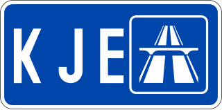
The Kranji Expressway in Singapore connects from the BKE in Bukit Panjang and travels south-west to join with the PIE in Jurong West. Construction of the expressway started in 1990 and was completed in 1994. The expressway is also the second shortest of all the expressways in Singapore at about 8 kilometres (5.0 mi), with the shortest currently being the Marina Coastal Expressway (MCE).
Bukit Gombak is a subzone of Bukit Batok, Singapore. It is a hilly neighbourhood in the west-central area of the Southeast Asian city-state of Singapore. In the Malay language, bukit means hill and gombak a bunch or collection of something. The neighbourhood consists of two hills. One of them stands at 133m while the other stands at 113m. They are Singapore's second and third highest natural point after Bukit Timah Hill.
The Jurong Police Division is one of the seven land divisions of the Singapore Police Force. Jurong Division first came into existence as the ‘Rural West’ Division on 24 Sep 1965 and operated from a standalone building located at Bukit Panjang. As the communities in the west grew, police posts were built in Ama Keng, Mandai and Kranji.

Yew Tee MRT station is an above-ground Mass Rapid Transit (MRT) station on the North South line in Choa Chu Kang, Singapore, located at Choa Chu Kang Drive near the junction of Choa Chu Kang North 6 and Choa Chu Kang Street 62. Yew Tee station is named after an expunged village that once stood in the area.

Kranji MRT station is an elevated Mass Rapid Transit (MRT) station on the North South line (NSL). Situated in Sungei Kadut, Singapore along Woodlands Road, it serves the Singapore Turf Club and the Woodlands Wafer Fabrication Park. The station is operated by SMRT Trains.
Admiralty MRT station is an elevated Mass Rapid Transit (MRT) station on the North South line (NSL) in Woodlands, Singapore. Located along Woodlands Avenue 7 near the junctions of Woodlands Avenue 6 and Woodlands Drive 71, the station primarily serves the residential precincts in the eastern part of Woodlands New Town. This station took its name from a former Royal Navy base located on the northern coast of Singapore.

Rail transport in Singapore mainly consists of a passenger urban rail transit system spanning the entire city-state: a rapid transit system collectively known as the Mass Rapid Transit (MRT) system operated by the two biggest public transport operators SMRT Trains and SBS Transit, as well as several Light Rail Transit (LRT) rubber-tyred automated guideway transit lines also operated by both companies. In addition, local specialised light rail lines are in operation in places such as the Singapore Changi Airport and Sentosa.

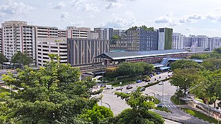
Choa Chu Kang Bus Interchange is a bus interchange which mainly serves the residential neighbourhood of Choa Chu Kang in the North Region of Singapore. It is located at Choa Chu Kang Loop and connected to Choa Chu Kang MRT/LRT station and the Lot One Shoppers' Mall. Opened in 1990, the old bus interchange was one of the oldest surviving bus interchanges in Singapore to remain intact from re-modification while still in service for 28 years until 15 December 2018. The new site opened on 16 December 2018.
Taman Jurong is a residential precinct in Jurong West, Singapore. It is one of the oldest residential precincts in Singapore and a division of Jurong GRC, with the area's HDB flats under the management of Jurong-Clementi Town Council and Shawn Huang as the area's MP.
Choa Chu Kang Road is a road in Singapore in two sections.

Sungei Kadut is an industrial estate and planning area located in the North Region of Singapore. It is bounded by Bukit Panjang and Choa Chu Kang to the south, Mandai to the east, as well as Lim Chu Kang and the Western Water Catchment to the west. Its northern boundary is defined by the Straits of Johor. Sungei Kadut is divided into five subzones, namely Kranji, Turf Club, Gali Batu, Pang Sua and Reservoir View.
Wenya is a subzone of Jurong West, Singapore.

Choa Chu Kang MRT/LRT station is an elevated Mass Rapid Transit (MRT) and Light Rail Transit (LRT) interchange station in Choa Chu Kang, Singapore. Serving the North South line (NSL) and the Bukit Panjang LRT line (BPLRT), the station is located near the Choa Chu Kang Bus Interchange and Lot One shopping centre. Other surrounding landmarks include Keat Hong Community Club and Choa Chu Kang Park.

Rural West Constituency was a constituency represented in the Legislative Council of Singapore from 1948 until 1951. It elected one Legislative Council member.
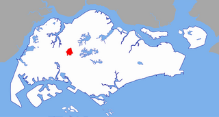
Choa Chu Kang is a planning area and residential town situated in the West Region of Singapore.
