Katong

Last updated

Katong
Subzone of Marine Parade Planning Area
Other transcription(s)
   Malay Tanjung Katong(Rumi)
تنجوڠ کاتوڠ(Jawi)
   Chinese 加东(Simplified)
加東(Traditional)
Jiādōng(Pinyin)
Ka-tong(Hokkien POJ)
   Tamil காத்தோங்
Kāttōṅ(Transliteration)
Katong1.jpg
Shophouses at Katong
CountryFlag of Singapore.svg  Singapore
Planning area Marine Parade
SubzoneKatong
Website www.katong.sg

Katong is a residential neighbourhood in the eastern portion of the Central Region of Singapore, within the Marine Parade planning area. Katong district stretches from Ford Road area to Joo Chiat area. It used to be located by the sea, before land reclamation towards the south to East Coast Park was created for housing and recreational purposes beginning in the 1960s to 1970s.

Contents

Katong was the location of many villas and mansions of the wealthy elite in the late 19th to the mid-20th centuries. They made their fortunes in the Far East and built seaside resorts, villas and manors along the beachfront of Katong, beginning from Katong Park to the end of the East Coast.

Katong's rich cultural mix has contributed to its unique cuisine. Katong is well known among locals as a food district with a variety of shophouse restaurants serving Peranakan cuisine and particularly, a spicy Singaporean noodle soup known as Katong laksa. Its famous icons include Joo Chiat Rd's food street, Duman food center, Koon Seng Road & Everitt Road 's Peranakan conservation house, Eurasian Heritage Gallery.[ citation needed ]

Etymology

Tanjong Katong was a popular beach along the East Coast. Tanjong means cape in Malay. This coastal feature was located near the present Tanjong Katong Flyover across East Coast Parkway and has since disappeared due to land reclamation.[ citation needed ]

When directly translated to English, it is known as Turtle Cape. [1]

History

John Edmund Taylor, Singapore. From Tanjong Katong. (1879, Wellcome V0037488).jpg
A watercolour painting of Katong facing the sea during the 1870s by John Edmund Taylor
Katong laksa.jpg
The Katong district is known for its unique laksa dish
Katong4.jpg
Katong Square's Conservation Building – currently tenanted by a Starbucks
Katong3.jpg
Shophouses at Katong

Many wealthy Chinese, English, Portuguese and Anglo-French settlers bought parcels of land in Katong beside the sea to cultivate plantations, and built business empires from trading in commodities such as cotton, coconut and gambier. One of them is the Wee family where Thiam Siew Avenue is named after them, now being The Continuum Condo. [2] Many of these plantations can be seen along Mountbatten Road.

Katong developed from a weekend seaside retreat into a home for the wealthy, who built immense colonial seaside bungalows away from the hustle and bustle of town life. The wealthy suburb stretched along Meyer Road and Mountbatten Road from Katong Park to Tanjong Katong. By 1928 Katong had grown to the extent that the Inspector-General of Police H. Fairburn remarked: "The development of the area from Katong to Joo Chiat, which has been so rapid in the past two years, promises to continue, and from every point of view one sees the necessity of providing for a sub-divisional station in the suburb. The suburb at present possess no police station." From then on Katong encroached into Joo Chiat area from Tanjong Katong to Telok Kurau Road. East Coast Road (now divided into East Coast Road and Upper East Coast Road) had many upper-class family homes.

The present Katong area stretches from Mountbatten Road, East Coast Road to Siglap. The Joo Chiat area of Katong was formerly an ethnic enclave of Eurasians fleeing congestion, pollution, and overcrowding in Singapore after the Great Depression.

Kampong Amber

In the early twentieth century, Kampong Amber, a Malay fishing village between East Coast Road and Amber Road, was a prominent landmark in the coastal area of Katong. [3] [4] The village was named after the adjacent Amber Road, which was in turn named after the clan name of Joseph Aaron Elias, a prominent property owner in early-20th-century Singapore. [5]

The inhabitants of Kampong Amber were mostly Malay fishermen, who lived in thatched timber houses on stilts, irregularly clustered into a porous urban fabric. [6] Between these houses were many large communal spaces, where the inhabitants spent much of their time, engaging in activities such as plucking beansprout, pounding chili paste, and talking to their neighbors. [7] Since the salty soil was unfriendly to agriculture, the villagers largely depended on the ocean for their livelihoods. [7]

Just across Amber Road were the beachfront bungalows of wealthy Peranakan businessmen, notably Lee Choon Guan and his wife, who owned the land which Kampong Amber sits on. [8] [9] [10] Mr and Mrs Lee allowed the villagers to live in Kampong Amber rent-free; as a show of appreciation, the villagers held an annual parade on Mrs Lee's birthday. [11]

As part of the 1971 Concept Plan, land reclamation along the East Coast was carried out between 1963 and 1985. [9] This reclaimed land transformed the swampy coastline with its foul smells into a scenic vista of white sandy beaches, and made it a desirable location for high-end residential developments; [7] at the same time, the reclaimed land and increased motor vehicle traffic on the road combined to separate the villagers of Kampong Amber from the ocean on which they depended.

As Singapore continued to industrialize through the 1970s, Kampong Amber was among the kampongs destroyed to make room for economic developments: first four- to eight-storey residential buildings, then high-rise flats. [8] [9] [12] The occupants were relocated to newly-built, government-subsidised flats. [7] [13] In a 2003 master plan, the land was parcelled out for further development. [7]

A few remnants of earlier Kampong Amber survived the process of industrialization. The iconic car porch of the Butterfly House, a beachfront bungalow built in 1912 by Regent A. J. Bidwell, was incorporated into a new 18-storey condo. [14] [15] [16] Another surviving early Kampong Amber landmark is the Chinese Swimming Club, founded in 1909 and moved to a permanent site at Amber Road in 1921. [17] Originally a Chinese response to the European-only Singapore Swimming-club founded by the British in 1894, [18] the Chinese Swimming Club was sponsored by wealthy philanthropist Lee Choon Guan. [19] The club went on to become a social gathering place, a training location for many world-class athletes, [20] [21] and a prominent local landmark that drew visits from figures including Prime Minister Lee Kuan Yew, President Wee Kim Wee, and President Tony Tan Keng Yam. [18] Today, the club extends membership to non-Chinese residents.

Highlights

The area is traditionally associated with the Eurasian and Peranakan community. However, many high-rise apartment blocks now stand alongside the traditional shophouses and Peranakan terrace houses. In 1993, the Joo Chiat neighbourhood which comprises the historical centre of Katong, with its uniquely Singaporean architecture mixing Chinese, Peranakan and English colonial styles, was designated a national heritage conservation area by the Singapore Government. The conservation area consists of many shop houses which are refurnished into cafes as well as specialty shops.

Residents

It was home to the earlier scions of the Englishmen Lord Mountbatten of Burma and Cathay Organisation film magnate, Loke Wan Tho. Its illustrious residents include the ancestral family of Minister Mentor Lee Kuan Yew and Senior Minister Goh Chok Tong. The former President Sellapan Ramanathan lived in Katong in his primary residence on Ceylon Road. Also home to performance artist Nicholas Tee.

Politics

Katong is part of the Marine Parade Group Representation Constituency whose Member of Parliament is Former Prime Minister and Emeritus Senior Minister Goh Chok Tong (Marine Parade), Fatimah Lateef (Geylang Serai) and Edwin Tong (Joo Chiat) of the People's Action Party. More than half of Katong falls under SM Goh's Marine Parade constituency.

See also

Related Research Articles

<span class="mw-page-title-main">Marine Parade</span> Planning Area and HDB Estate in Central Region ----, Singapore

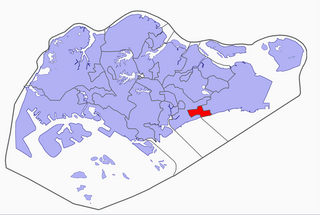
Marine Parade is a planning area and residential estate located in the Central Region of Singapore. Straddling the tip of the southeastern coast of Pulau Ujong, Marine Parade serves as a buffer between the Central and East regions of the city-state. Bordering it are the planning areas of Geylang to the north, Kallang to the northwest, Bedok to the northeast, Marina East to the southwest and the Singapore Straits to the south.

<span class="mw-page-title-main">Kallang</span> Planning Area and HDB Town in Central Region ----, Singapore

Kallang is a planning area and residential zone located in the Central Region of Singapore.

<span class="mw-page-title-main">Bedok</span> Planning Area and HDB Town in East Region ----, Singapore

Bedok is a planning area and residential town located in the geographical region of Tanah Merah along the south-eastern coast of the East Region of Singapore. Bedok is bounded by five other planning areas: Paya Lebar to the north, Hougang to the northwest, Tampines to the northeast and east, Geylang to the west and Marine Parade to the southwest. It also shares a maritime boundary with the Singapore Strait to the south and southeast.

<span class="mw-page-title-main">Kampong Glam</span> Neighborhood within Rochor Planning Area, Central Region, Singapore

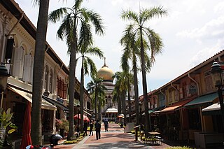
Kampong Glam is a neighbourhood and ethnic enclave in Singapore. It is located north of the Singapore River, in the planning area of Rochor, known as the Malay-Muslim quarter.

<span class="mw-page-title-main">Siglap</span> Place in East Region, Singapore

Siglap is a neighbourhood located south-west of Bedok in the East Region of Singapore. The area encompasses the Frankel and Opera Estates and their names have sometimes been used interchangeably to refer to the approximate same area. The planning subzone area of Siglap, as defined by the Urban Redevelopment Authority (URA), is confusingly and inaccurately referred to as the small strip of land between Victoria Junior College and Bedok South Avenue 1.

The Bedok Police Division is one of the seven land division of the Singapore Police Force. Bedok Division covers approximately 114 square kilometres of the eastern sector of Singapore. The building became operational on 1 August 1987 when the former Joo Chiat Police Station at East Coast Road was closed down.

<span class="mw-page-title-main">Joo Chiat Single Member Constituency</span>

Joo Chiat Single Member Constituency was a single member constituency (SMC) located in the eastern region of Singapore. The SMC encompasses the areas of Joo Chiat, Katong, opera estate, Siglap and a portion of Telok Kurau. It had previously existed from 1959 until 1988, when it was merged with neighbouring constituencies to form Bedok Group Representation Constituency. It was reformed just before the 2001 general election after being carved out from East Coast Group Representation Constituency. The seat has been held by the People's Action Party since its reformation that year and was contested again in 2006.

<span class="mw-page-title-main">Tanjong Rhu</span> Subzone of Kallang Planning Area in Central Region

Tanjong Rhu is a subzone within the planning area of Kallang, Singapore, as defined by the Urban Redevelopment Authority (URA). The perimeter of Tanjong Rhu is made up of Nicoll Highway in the north; Mountbatten Road and Fort Road in the east; East Coast Parkway (ECP) in the south; as well as Marina Channel and Kallang Basin in the west. Tanjong Rhu is the largest in terms of physical area among the nine subzones that make up Kallang.

<span class="mw-page-title-main">Joo Chiat Road</span> Place in Singapore

Joo Chiat Road is a road in Katong and a residential conservation area located in the east coast of Singapore. It has won several architectural and heritage awards including the United Nations' UNESCO Asia-Pacific Awards for Cultural Heritage Conservation at 125 Joo Chiat Road. It has overtaken Holland Village in terms of most diverse eateries. Currently, Joo Chiat has become one of the hippiest and coolest towns in Singapore, with both rich and young professionals flocking to its numerous Michelin awarded restaurants. Joo Chiat Road carries a rich historical Peranakan architecture and is infused with rich Peranakan culture, as it has the most historical Peranakan buildings in the Katong district. Joo Chiat was named after a businessman by the name of Chew Joo Chiat after he donated the land to the Municipality of Singapore.

Mountbatten is a neighbourhood located in the planning area of Marine Parade, Singapore.

<span class="mw-page-title-main">South East Community Development Council</span>

The South East Community Development Council is one of five Community Development Councils (CDCs) set up across the Republic of Singapore to aid in local administration of governmental policies and schemes. They are funded in part by the government although they are free to engage in fund-raising activities.

<span class="mw-page-title-main">Katong Park MRT station</span> Future Mass Rapid Transit station in Singapore

Katong Park MRT station is a future underground Mass Rapid Transit station on the Thomson–East Coast line situated at the boundary of the planning areas of Kallang and Marine Parade, Singapore. The station is located underneath the junction of Fort Road, Tanjong Rhu Road and Meyer Road and will serve the Katong Park.

<span class="mw-page-title-main">Tanjong Katong MRT station</span> Future Mass Rapid Transit station in Singapore

Tanjong Katong MRT station is a future underground Mass Rapid Transit station on the Thomson-East Coast Line in Marine Parade, Singapore.

<span class="mw-page-title-main">Marine Parade MRT station</span> Future Mass Rapid Transit station in Singapore

Marine Parade MRT station is a future underground Mass Rapid Transit station on the Thomson–East Coast line in Marine Parade, Singapore.

<span class="mw-page-title-main">Katong laksa</span> Singaporean noodle dish

Katong laksa is a variant of laksa lemak inspired by the Peranakans who live in the precinct of Katong in Singapore. It has an orangey-yellow colour spicy soup stock, flavoured with coconut milk and dried shrimp, topped with ingredients like cockles, prawns and fishcake. The noodles are normally cut up into smaller pieces so that the entire dish can be eaten with a spoon alone, without chopsticks or a fork.

<span class="mw-page-title-main">Sino-Portuguese architecture</span> Asian hybrid architecture style

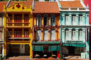
Sino-Portuguese architecture, also known as Chinese Baroque,Straits/Singapore Eclectic architecture or Peranakan architecture is an Asian hybrid style incorporating elements of both Chinese and Portuguese architectural styles. It is common in urban centers where Chinese settlers lived in southern China and the Peranakans of the Malay Peninsula, with examples found and most prominently conserved and maintained in Singapore.

<span class="mw-page-title-main">Katong Park</span> Park in Katong, Singapore

Katong Park is neighborhood park located in Katong, Singapore at the junction of Meyer Road and Fort Road. Built in the 1930s above the buried remains of Fort Tanjong Katong, it was one of Singapore’s oldest parks with the first public bathing pagar and was highly popular with families during the weekends. After the coastal reclamation works in the 1970s, the park lost its sea frontage and declined greatly in popularity. It now remains as a small community park serving nearby residents.

References

  1. Lee, Joshua (9 October 2017). "Katong's name comes from a sea mirage you see when looking at the shoreline". mothership.sg. Retrieved 14 April 2022.
  2. "The Continuum | New Freehold Condo at Thiam Siew Avenue" . Retrieved 24 October 2023.
  3. M, Jafri (1993). A Katong Story. Singapore: Marie Claire. pp. 20–22.
  4. Low, Eunice (2002). Life in Katong. Singapore: Singapore : National Library Board.
  5. Peter, Keys (1988). Singapore: A Guide to Buildings, Streets, Places. Kuala Lumpur: Kuala Lumpur: Times Book International. pp. 291, 302.
  6. Urban Redevelopment Board. "Singapore Master Plan 1980." Map. 1980. https://www.ura.gov.sg/dc/mp80/mp80map_index.htm
  7. 1 2 3 4 5 Vincent, Gabriel. "Special Project." Interview by Claire Yeo. Retrieved 26 February 2017. http://www.nas.gov.sg/archivesonline/oral_history_interviews/record-details/fabda1a5-115e-11e3-83d5-0050568939ad?keywords=vincent%20gabriel%20amber&keywords-type=all. Accession Number 002909
  8. 1 2 Wee, Ban Kheng, Peter. "Story of Joo Chiat Changing Landscapes & Community." Interview by Zaleha Bte Osman. Retrieved 26 February 2017. http://www.nas.gov.sg/archivesonline/oral_history_interviews/record-details/5e4e04ab-115e-11e3-83d5-0050568939ad?keywords=kampong%20amber&keywords-type=all. Accession Number 002100
  9. 1 2 3 Low, Eunice. Life in Katong. Singapore: National Library Board, 2002. (Call no.: RSING 959.57 LIF)
  10. Lee, Peter. Rumah baba: Life in a Peranakan house. Singapore: National Heritage Board, 1998. p. 25. (Call no.: RSING 305.89510595 LEE)
  11. Lee, Kip Lin., and Gretchen Liu. The Singapore house, 1819–1942. Singapore: Times Editions [for] Preservation of Monuments Board, 1988. p. 193. (Call no.: RSING 728.095957 LEE)
  12. Lily, Kong (2001). Joo Chiat: A Living Legacy. Singapore: Joo Chiat Citizen's Consultative Committee.
  13. Kong, Lily, and T. C. Chang. Joo Chiat: a living legacy. Singapore: Joo Chiat Citizens' Consultative Committee in association with National Archives of Singapore, 2001. pp. 37, 111. (Call no.: RSING 959.57 KON)
  14. ""Conservation." Urban Redevelopment Authority. Retrieved March 2, 2017". URA.gov.sg. Retrieved 24 May 2017.
  15. "The Old East Coast (3) – On the Seashore in front of 23 Amber Road". 2ndshot.Blogspot.sg. 24 March 2010. Retrieved 24 May 2017.
  16. "skyline : The Fragile Balance: Conservation or Commerce?". URA.gov.sg. Retrieved 24 May 2017.
  17. "NewspaperSG – Terms and Conditions". NLB.gov.sg. Retrieved 24 May 2017.
  18. 1 2 Singapore Chinese Swimming Club: 88 years and beyond . Singapore: Singapore Chinese Swimming Club, 1998. pp. 20, 22–36. (Call no.: RSING 797.200605957 SIN)
  19. Singapore Chinese Swimming Club: 88 years and beyond. Singapore: Singapore Chinese Swimming Club, 1998. pp. 20, 22–36. (Call no.: RSING 797.200605957 SIN)
  20. Ng, D. H. L. (Interviewer). (2015, April 2). Oral history interview with Chan, Patricia Li-Yin. (MP3 Recording no.: 002629/18/8). Retrieved from National Archives of Singapore
  21. Singapore Chinese Swimming Club. (1998). Singapore Chinese Swimming Club: 88 years and beyond. Singapore: Singapore Chinese Swimming Club. pp. 116–125. (Call no.: RSING 797.200605957 SIN); $45m facelift for Chinese Swimming Club. (24 January 2002). The Straits Times, p. 6. Retrieved from NewspaperSG.

Further reading