
Posey County is the southernmost, southwesternmost, and westernmost county in the U.S. state of Indiana. Its southern border is formed by the Ohio River, and its western border by the Wabash River, a tributary to the Ohio. As of 2010, the population was 25,910. The county seat is Mount Vernon.

Caborn-Welborn was a precontact and proto-historic North American culture defined by archaeologists as a Late Mississippian cultural manifestation that grew out of – or built upon the demise of – the Angel chiefdom located in present-day southern Indiana. Caborn-Welborn developed around 1400 and seems to have disappeared around 1700 CE. The Caborn-Welborn culture was the last Native American occupation of southern Indiana prior to European contact. It remains unclear which post-contact Native group, if any, are their descendants.

Bethel Township is one of ten townships in Posey County, Indiana. As of the 2000 census, its population was 327.

Center Township is one of ten townships in Posey County, Indiana. As of the 2000 census, its population was 1,321.

Lynn Township is one of ten townships in Posey County, Indiana. As of the 2000 census, its population was 945.

Marrs Township is one of ten townships in Posey County, Indiana. As of the 2000 census, its population was 4,868.

Point Township is one of ten townships in Posey County, Indiana. As of the 2000 census, its population was 497. The lowest, the southernmost, and the westernmost points in Indiana are all located along the township's boundaries.

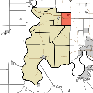
Robb Township is one of ten townships in Posey County, Indiana. As of the 2000 census, its population was 2,074.
Smith Township is one of ten townships in Posey County, Indiana, USA. At the 2000 census, its population was 1,292.

Wadesville is a census designated place in northern Center Township, Posey County, in the U.S. state of Indiana. It lies along State Road 66 northeast of the city of Mt. Vernon, the county seat of Posey County. Although Wadesville is unincorporated, it has a post office, with the ZIP code of 47638.

The Ashworth Archaeological Site is a significant archaeological site in the extreme southwestern corner of the U.S. state of Indiana. Located near the confluence of the Ohio and Wabash Rivers, it lies near several similar archaeological sites. It was first examined by archaeologists in the middle of the twentieth century and found to be the site of a relatively recent Native American village, and it has been designated a historic site because of its archaeological value.
Rapture is an unincorporated community in Harmony Township, Posey County, in the U.S. state of Indiana.
Farmersville is an unincorporated community in Black Township, Posey County, in the U.S. state of Indiana.
Saint Philip is an unincorporated community in Marrs Township, Posey County, in the U.S. state of Indiana.
Stewartsville is an unincorporated community and Census Designated Place in Robb Township, Posey County, in the U.S. state of Indiana.
West Franklin is an unincorporated community in Marrs Township, Posey County, in the U.S. state of Indiana.
Grafton is an unincorporated community in Black Township, Posey County, in the U.S. state of Indiana.
New Baltimore is an unincorporated community in Bethel Township, Posey County, in the U.S. state of Indiana.
Springfield is an unincorporated community in Lynn Township, Posey County, in the U.S. state of Indiana.


