Cynthiana, Indiana

Last updated

Cynthiana, Indiana
Posey County Indiana Incorporated and Unincorporated areas Cynthiana Highlighted 1816534.svg
Location of Cynthiana in Posey County, Indiana.
Coordinates: 38°11′14″N87°42′31″W / 38.18722°N 87.70861°W / 38.18722; -87.70861 [1]
Country United States
State Indiana
County Posey
Township Smith
Area
[2]
  Total0.40 sq mi (1.03 km2)
  Land0.40 sq mi (1.03 km2)
  Water0.00 sq mi (0.00 km2)
Elevation
[1]
469 ft (143 m)
Population
 (2020)
  Total552
  Density1,383.46/sq mi (534.42/km2)
Time zone UTC-6 (CST)
  Summer (DST) UTC-5 (CDT)
ZIP code
47612
Area code 812
FIPS code 18-16534 [3]
GNIS feature ID2396673 [1]

Cynthiana is a town in Smith Township, Posey County, in the U.S. state of Indiana. [1] The population was 545 at the 2010 census.

Contents

History

Cynthiana was named for Cynthiana, Kentucky, from whence on September 25, 1815, a group of 44 settlers had come. More settlers from the same area continued to migrate to the area over the following several years. On March 6, 1817, the town was laid out by William Davis, with the plat being recorded on March 17, 1817. It was not until April 22, 1896, that the town incorporated. [4]

On September 23, 1815, Thomas Duncan had made a land entry for the SE 1/4 of Section 11, Township 4 South, Range 11 West of the Second Principal Meridian, receiving a patent to the land on December 20, 1817. It was on March 24, 1818, that he sold the 58½ acres for the townsite of Cynthiana to William Davis. [5]

A post office has been in operation at Cynthiana since 1820. [6]

Geography

According to the 2010 census, Cynthiana has a total area of 0.4 square miles (1.04 km2), all land. [7]

Demographics

Historical population
CensusPop.Note
1880 313
1900 502
1910 61021.5%
1920 568−6.9%
1930 556−2.1%
1940 535−3.8%
1950 59110.5%
1960 66312.2%
1970 79319.6%
1980 87410.2%
1990 669−23.5%
2000 6933.6%
2010 545−21.4%
2020 5521.3%
U.S. Decennial Census [8]

2010 census

As of the census [9] of 2010, there were 545 people, 236 households, and 154 families living in the town. The population density was 1,362.5 inhabitants per square mile (526.1/km2). There were 272 housing units at an average density of 680.0 per square mile (262.5/km2). The racial makeup of the town was 96.5% White, 0.2% African American, 0.2% Native American, 0.2% Asian, 0.4% from other races, and 2.6% from two or more races. Hispanic or Latino of any race were 0.6% of the population.

There were 236 households, of which 30.9% had children under the age of 18 living with them, 48.3% were married couples living together, 11.4% had a female householder with no husband present, 5.5% had a male householder with no wife present, and 34.7% were non-families. 31.4% of all households were made up of individuals, and 14.4% had someone living alone who was 65 years of age or older. The average household size was 2.31 and the average family size was 2.80.

The median age in the town was 42.5 years. 22.6% of residents were under the age of 18; 7.3% were between the ages of 18 and 24; 23.3% were from 25 to 44; 31.9% were from 45 to 64; and 14.9% were 65 years of age or older. The gender makeup of the town was 49.7% male and 50.3% female.

2000 census

As of the census [3] of 2000, there were 693 people, 265 households, and 195 families living in the town. The population density was 1,725.1 inhabitants per square mile (666.1/km2). There were 286 housing units at an average density of 711.9 per square mile (274.9/km2). The racial makeup of the town was 98.56% White, 0.43% Native American, 0.29% Asian, and 0.72% from two or more races.

There were 265 households, out of which 34.0% had children under the age of 18 living with them, 64.2% were married couples living together, 7.5% had a female householder with no husband present, and 26.4% were non-families. 24.5% of all households were made up of individuals, and 12.5% had someone living alone who was 65 years of age or older. The average household size was 2.62 and the average family size was 3.11.

In the town, the population was spread out, with 27.7% under the age of 18, 7.1% from 18 to 24, 29.7% from 25 to 44, 22.4% from 45 to 64, and 13.1% who were 65 years of age or older. The median age was 36 years. For every 100 females, there were 96.3 males. For every 100 females age 18 and over, there were 97.2 males.

The median income for a household in the town was $37,589, and the median income for a family was $42,000. Males had a median income of $35,286 versus $20,583 for females. The per capita income for the town was $15,313. About 5.3% of families and 9.7% of the population were below the poverty line, including 11.9% of those under age 18 and 18.5% of those age 65 or over.

Education

The town and northern half of Posey County is served by the MSD of North Posey County which currently operates four schools:

Highways

Related Research Articles

<span class="mw-page-title-main">Staunton, Indiana</span> Town in Indiana, United States

Staunton is a town in Posey Township, Clay County, Indiana, United States. The population was 534 at the 2010 census. It is part of the Terre Haute Metropolitan Statistical Area.

<span class="mw-page-title-main">St. Paul, Indiana</span> Town in Indiana, United States

St. Paul or Saint Paul is a small town on the border of Decatur and Shelby counties in the U.S. state of Indiana. The population was 1,031 at the 2010 census.

<span class="mw-page-title-main">Ashley, Indiana</span> Town in Indiana, United States

Ashley is a town in Indiana located on the border of Smithfield Township, DeKalb County and Steuben Township, Steuben County. The population was 983 at the 2010 census.

<span class="mw-page-title-main">Albany, Indiana</span> Town in Indiana, United States

Albany is a town in Delaware and Randolph counties in the U.S. state of Indiana, along the Mississinewa River. The population was 2,295 at the 2020 census. It is part of the Muncie, IN Metropolitan Statistical Area.

<span class="mw-page-title-main">Selma, Indiana</span> Town in Indiana, United States

Selma is a town in Liberty Township, Delaware County, Indiana, United States. As of the 2020 census, the town had a total population of 747. It is part of the Muncie, IN Metropolitan Statistical Area.

<span class="mw-page-title-main">McCordsville, Indiana</span> Town in Indiana, United States

McCordsville is a town in Vernon Township, Hancock County, Indiana, United States. The town is a fast-growing suburb of Indianapolis with an estimated population of 8,592 in 2020.

<span class="mw-page-title-main">Wilkinson, Indiana</span> Town in Indiana, United States

Wilkinson is a town in Brown Township, Hancock County, Indiana, United States. The population was 449 at the 2010 census.

<span class="mw-page-title-main">Elizabeth, Indiana</span> Town in Indiana, United States

Elizabeth is a town in Posey Township, Harrison County, Indiana, United States. The population was 162 at the 2010 census.

<span class="mw-page-title-main">Andrews, Indiana</span> Town in Indiana, United States

Andrews is a town in Dallas Township, Huntington County, Indiana, United States. The population was 1,048 at the 2020 census.

<span class="mw-page-title-main">Etna Green, Indiana</span> Town in Indiana, United States

Etna Green is a town in Etna Township, Kosciusko County, in the U.S. state of Indiana. The population was 586 at the 2010 census.

<span class="mw-page-title-main">Pottawattamie Park, Indiana</span> Town in Indiana, United States

Pottawattamie Park is a town in Michigan Township, LaPorte County, Indiana, United States. The population was 235 at the 2010 census. It is included in the Michigan City, Indiana-La Porte, Indiana Metropolitan Statistical Area.

<span class="mw-page-title-main">Petersburg, Indiana</span> City in Indiana, United States

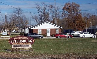
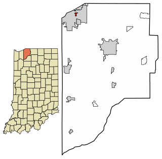
Petersburg is a city within Washington Township and the county seat of Pike County, in the U.S. state of Indiana. The population was 2,383 at the 2010 census.

<span class="mw-page-title-main">Griffin, Indiana</span> Town in Indiana, United States

Griffin is a town in Bethel Township, Posey County, in the U.S. state of Indiana. The population was 172 at the 2010 census.

<span class="mw-page-title-main">Poseyville, Indiana</span> Town in Indiana, United States

Poseyville is a town in Robb Township, Posey County, in the U.S. state of Indiana. The population was 1,045 at the 2010 census.

<span class="mw-page-title-main">Clear Lake, Indiana</span> Town in Indiana, United States

Clear Lake is a town located in the northeast corner of Steuben County, Indiana, in Clear Lake Township. As such, is the northeasternmost community in the State of Indiana. The population was 339 at the 2010 census.

<span class="mw-page-title-main">Hudson, Indiana</span> Town in Indiana, United States

Hudson is a town in Salem and Steuben townships, Steuben County, in the U.S. state of Indiana. The population was 518 at the 2010 census.

<span class="mw-page-title-main">Patriot, Indiana</span> Town in Indiana, United States

Patriot is a town in Posey Township, Switzerland County, in the U.S. state of Indiana, along the Ohio River. The population was 209 at the 2010 census.

<span class="mw-page-title-main">Fredericksburg, Indiana</span> Census-designated place in Indiana, United States

Fredericksburg is an unincorporated community in Posey Township, Washington County, in the U.S. state of Indiana. The population was 85 at the 2010 census, at the time it was a town.

<span class="mw-page-title-main">Hardinsburg, Indiana</span> Town in Indiana, United States

Hardinsburg is a town in Posey Township, Washington County, in the U.S. state of Indiana. The population was 222 at the 2020 census.

<span class="mw-page-title-main">Poneto, Indiana</span> Town in Indiana, United States

Poneto is a town in Chester, Harrison and Liberty townships, Wells County, in the U.S. state of Indiana. The population was 166 at the 2010 census.

References

  1. 1 2 3 4 U.S. Geological Survey Geographic Names Information System: Cynthiana, Indiana
  2. "2020 U.S. Gazetteer Files". United States Census Bureau. Retrieved March 16, 2022.
  3. 1 2 "U.S. Census website". United States Census Bureau . Retrieved January 31, 2008.
  4. Cynthiana Sesquicentennial Committee (1967). Cynthiana, Indiana: Journey's End of an American Pioneer Trail. Cynthiana Argus. p. 5.
  5. Cynthiana Sesquicentennial Committee (1967). Cynthiana, Indiana: Journey's End of an American Pioneer Trail. Cynthiana Argus. p. 6.
  6. "Posey County". Jim Forte Postal History. Retrieved April 1, 2017.
  7. "G001 - Geographic Identifiers - 2010 Census Summary File 1". United States Census Bureau. Archived from the original on February 13, 2020. Retrieved July 16, 2015.
  8. "Census of Population and Housing". Census.gov. Retrieved June 4, 2015.
  9. "U.S. Census website". United States Census Bureau . Retrieved December 11, 2012.