Marrs Township, Posey County, Indiana

Last updated

Marrs Township
Posey County
Map highlighting Marrs Township, Posey County, Indiana.svg
Coordinates: 37°56′47″N87°45′21″W / 37.94639°N 87.75583°W / 37.94639; -87.75583
Country United States
State Indiana
County Posey
Government
  Type Indiana township
Area
  Total52.12 sq mi (134.98 km2)
  Land51.54 sq mi (133.5 km2)
  Water0.57 sq mi (1.48 km2)
Elevation
[1]
436 ft (133 m)
Population
 (2020)
  Total5,385
  Density94.44/sq mi (36.47/km2)
FIPS code 18-47250 [2]
GNIS feature ID 453614

Marrs Township is one of ten townships in Posey County, Indiana. At the 2000 census, its population was 4,868. By the 2020 census it had risen to 5,385. [3]

Contents

Historical population
CensusPop.Note
1890 2,066
1900 2,1996.4%
1910 2,008−8.7%
1920 1,736−13.5%
1930 1,7581.3%
1940 1,9008.1%
1950 2,0065.6%
1960 2,50024.6%
1970 2,93117.2%
1980 4,18242.7%
1990 4,4626.7%
2000 4,8689.1%
2010 5,1776.3%
2020 5,3884.1%
Source: US Decennial Census [4]

History

Marrs Township was organized in 1817. [5] The township was named for Samuel R. Marrs, a pioneer settler and afterward county commissioner. [6]

Demographics

2020 Census

At the 2020 census there were 5,385 people, 2,094 housing units and 1,949 households residing in the township. The population density was 104.6 inhabitants per square mile. The racial makeup was 94% White, 1% African American, 0% Native American, 1% Asian, 0% Pacific Islander, 2% from other races, and 2% from two or more races. Hispanic or Latino of any race was 0% of the population. [3]

Of the family households, 76% were married couples, 5% were a male householder with no spouse, and 5% were a female householder with no spouse. The average household had 2.8 people. [3]

The median age was 40.1, 26% of people were under the age of 18, and 18% were 65 years of age or older. Of the residents none spoke a language other than English at home, and 1.3% were born outside the United States, 13% in Europe and 87% in Asia. [3]

The median income for a household in the township was $119,933. 5.9% of the population were military veterans, and 34.2% had a batchelors degree or higher. In the CDP 9.9% of the population was below the poverty line, including 10% of those under age 18 and 12% of those age 65 or over. [3]

Adjacent townships

Unincorporated places

Related Research Articles

<span class="mw-page-title-main">Posey County, Indiana</span> County in Indiana, United States

Posey County is the southernmost, southwesternmost, and westernmost county in the U.S. state of Indiana. Its southern border is formed by the Ohio River, and its western border by the Wabash River, a tributary to the Ohio. As of 2020, the population was 25,222. The county seat is Mount Vernon.

<span class="mw-page-title-main">Staunton, Indiana</span> Town in Indiana, United States

Staunton is a town in Posey Township, Clay County, Indiana, United States. The population was 534 at the 2010 census. It is part of the Terre Haute Metropolitan Statistical Area.

<span class="mw-page-title-main">Elizabeth, Indiana</span> Town in Indiana, United States

Elizabeth is a town in Posey Township, Harrison County, Indiana, United States. The population was 162 at the 2010 census.

<span class="mw-page-title-main">Etna Green, Indiana</span> Town in Indiana, United States

Etna Green is a town in Etna Township, Kosciusko County, in the U.S. state of Indiana. The population was 586 at the 2010 census.

<span class="mw-page-title-main">Pierceton, Indiana</span> Town in Indiana, United States

Pierceton is a town in Washington Township, Kosciusko County, in the U.S. state of Indiana. The population was 928 at the 2020 census.

<span class="mw-page-title-main">Syracuse, Indiana</span> Town in Indiana, United States

Syracuse is a town in Turkey Creek Township, Kosciusko County, in the U.S. state of Indiana. The population was 3,079 at the 2020 census. Syracuse is the location of Lake Syracuse and the nearby, larger Lake Wawasee, in addition to several other lakes in the region. The National Weather Service operates a Weather Forecast Office South of town, toward North Webster. It serves Northern Indiana, Northwestern Ohio and Southwestern Michigan.

<span class="mw-page-title-main">Petersburg, Indiana</span> City in Indiana, United States

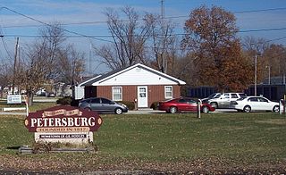
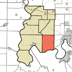
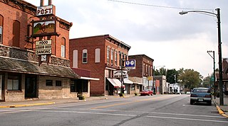
Petersburg is a city within Washington Township and the county seat of Pike County, in the U.S. state of Indiana. The population was 2,383 at the 2010 census.

<span class="mw-page-title-main">Cynthiana, Indiana</span> Place in Indiana, United States

Cynthiana is a town in Smith Township, Posey County, in the U.S. state of Indiana. The population was 545 at the 2010 census.

<span class="mw-page-title-main">Griffin, Indiana</span> Town in Indiana, United States

Griffin is a town in Bethel Township, Posey County, in the U.S. state of Indiana. The population was 172 at the 2010 census.

<span class="mw-page-title-main">Mount Vernon, Indiana</span> City in Indiana, United States

Mount Vernon is a city in and the county seat of Posey County, Indiana, United States. Located in the state's far southwestern corner, within 15 miles (24 km) of both the southernmost or westernmost points, it is the westernmost city in the state. The southernmost is Rockport, located along the Ohio River about 40 miles (64 km) to the southeast.

<span class="mw-page-title-main">Poseyville, Indiana</span> Town in Indiana, United States

Poseyville is a town in Robb Township, Posey County, in the U.S. state of Indiana. The population was 1,045 at the 2010 census.

<span class="mw-page-title-main">Cleves, Ohio</span> City in Ohio, United States

Cleves is a village in Miami Township, Hamilton County, Ohio, United States. Located along the Ohio River, it is a western suburb of Cincinnati. The population was 3,414 at the 2020 census.

<span class="mw-page-title-main">Harrison, Ohio</span> City in Ohio, United States

Harrison is a city in western Hamilton County, Ohio, United States. The population was 12,563 at the 2020 census. It is part of the Cincinnati metropolitan area.

<span class="mw-page-title-main">Pleasant Run, Ohio</span> Census-designated place in Ohio, United States

Pleasant Run is a census-designated place (CDP) in Colerain Township, Hamilton County, Ohio, United States. The population was 4,861 at the 2020 census.

<span class="mw-page-title-main">White Oak, Ohio</span> Census-designated place in Ohio, United States

White Oak is a census-designated place (CDP) in Hamilton County, Ohio, United States. It is seven miles northwest of Cincinnati. The population was 19,541 at the 2020 census. White Oak is situated in both Green Township and Colerain Township.

<span class="mw-page-title-main">Harrison Township, Hamilton County, Ohio</span> Township in Ohio, United States

Harrison Township is one of the twelve townships of Hamilton County, Ohio, United States. The 2020 census found 14,288 people in the township.

<span class="mw-page-title-main">Miami Township, Hamilton County, Ohio</span> Township in Ohio, United States

Miami Township is one of the twelve townships of Hamilton County, Ohio, United States. The population was 15,969 as of the 2020 census.

<span class="mw-page-title-main">Sycamore Township, Hamilton County, Ohio</span> Township in Ohio, United States

Sycamore Township is one of the twelve townships of Hamilton County, Ohio, United States. The population was 19,563 as of the 2020 census.

<span class="mw-page-title-main">Whitewater Township, Hamilton County, Ohio</span> Township in Ohio, United States

Whitewater Township is one of the twelve townships of Hamilton County, Ohio, United States. The population was 6,375 as of the 2020 census.

<span class="mw-page-title-main">Lake Township, Clinton County, Illinois</span> Township in Illinois, United States

Lake Township is one of fifteen townships in Clinton County, Illinois, USA. As of the 2020 census, its population was 812 and it contained 373 housing units. Lake Township was formed from part of Crooked Creek (Brookside) Township.

References

  1. "US Board on Geographic Names". United States Geological Survey. October 25, 2007. Retrieved January 31, 2008.
  2. "U.S. Census website". United States Census Bureau . Retrieved January 31, 2008.
  3. 1 2 3 4 5 "Census profile: Marrs township, Posey County, IN". Census Reporter. Retrieved January 26, 2024.
  4. "Township Census Counts: STATS Indiana".
  5. Leffel, John C. (1913). History of Posey County, Indiana. Standard Publishing Company. p.  81.
  6. History of Posey County, Indiana: from the earliest times to the present. Goodspeed Publishing Co. 1886. p. 311.