Central Hawke's Bay District

Last updated

Central Hawke's Bay District
Waipawa.jpg
Waipawa
Central Hawke's Bay DC.PNG
Coordinates: 40°02′20″S176°34′41″E / 40.039°S 176.578°E / -40.039; 176.578
CountryNew Zealand
Region Hawke's Bay
WardsAramoana-Ruahine
Ruataniwha
Seat Waipawa
Government
  MayorAlex Walker
  Deputy MayorKelly Annand
   Territorial authority Central Hawke's Bay District Council
Area
[1]
  Land3,333.00 km2 (1,286.88 sq mi)
Population
 (June 2023) [2]
  Total16,000
Time zone UTC+12 (NZST)
  Summer (DST) UTC+13 (NZDT)
Postcode(s)
Website www.chbdc.govt.nz OOjs UI icon edit-ltr-progressive.svg

Central Hawke's Bay District is in the Hawke's Bay Region in the North Island of New Zealand. Formed in 1989, it covers an area of 3,333 square kilometres, from Pukehou in the north to Takapau in the south, and from the western Ruahine Range to the Pacific coast in the east. It has a population of 16,000(June 2023), [2] up from 14,142 in the 2018 census and 12,717 in the 2013 census. [3]

Contents

Geography

The two main towns are Waipukurau (population 4,750) and Waipawa (2,400), [2] which are just 7 kilometres (4.3 mi) apart. Smaller townships include Ōtāne, Takapau, Tikokino and Ongaonga. There are also several small beach communities, including Kairakau, Pourerere, Aramoana, Blackhead and Pōrangahau.

There is a marae in each of the four corners of the district, at Pukehou, Kairakau, Pōrangahau and Takapau.

Local government

The district is administered by the Central Hawke's Bay District Council, which was formed through the 1989 local government reforms by amalgamating Waipukurau District Council and the Waipawa District Council. [4] The district is divided into two wards: Ruataniwha is an urban ward based on the towns of Waipukurau and Waipawa; Aramoana-Ruahine is a largely rural ward. The council seat is in Waipawa.

Demographics

Central Hawke's Bay District covers 3,333.00 km2 (1,286.88 sq mi) [1] and had an estimated population of 16,000 as of June 2023, [2] with a population density of 4.8 people per km2.

Historical population
YearPop.±% p.a.
200612,957    
201312,717−0.27%
201814,142+2.15%
202315,480+1.82%
Source: [5] [6]
Ethnicities, 2023 Census
EthnicityPopulation
New Zealand European
12,987
Māori
3,903
Pasifika
483
Asian
456
MELAA
69
Other
198

Central Hawke's Bay District had a population of 15,480 in the 2023 New Zealand census, an increase of 1,338 people (9.5%) since the 2018 census, and an increase of 2,763 people (21.7%) since the 2013 census. There were 6,936 dwellings. There were 3,150 people (20.3%) aged under 15 years, 2,181 (14.1%) aged 15 to 29, 6,864 (44.3%) aged 30 to 64, and 3,294 (21.3%) aged 65 or older. [6]

Ethnicities were 83.9% European/Pākehā, 25.2% Māori, 3.1% Pasifika, 2.9% Asian, 0.4% Middle Eastern, Latin American and African New Zealanders, and 1.3% other. People may identify with more than one ethnicity. [6]

Central Hawke's Bay District had a population of 14,142 at the 2018 New Zealand census. There were 5,418 households, comprising 7,014 males and 7,125 females, giving a sex ratio of 0.98 males per female. The median age was 44.2 years (compared with 37.4 years nationally).

The percentage of people born overseas was 12.1, compared with 27.1% nationally.

Although some people chose not to answer the census's question about religious affiliation, 50.8% had no religion, 37.2% were Christian, 2.2% had Māori religious beliefs, 0.2% were Hindu, 0.1% were Muslim, 0.3% were Buddhist and 1.6% had other religions.

Of those at least 15 years old, 1,482 (13.2%) people had a bachelor's or higher degree, and 2,631 (23.5%) people had no formal qualifications. The median income was $29,000, compared with $31,800 nationally. 1,128 people (10.1%) earned over $70,000 compared to 17.2% nationally. The employment status of those at least 15 was that 5,640 (50.4%) people were employed full-time, 1,746 (15.6%) were part-time, and 330 (2.9%) were unemployed. [5]

Individual statistical areas
NameArea (km2)PopulationDensity (per km2)HouseholdsMedian ageMedian income
Aramoana-Ruahine Ward3,273.037,0742.162,59242.6 years$32,000
Ruataniwha Ward59.977,068117.862,82645.9 years$26,900
New Zealand37.4 years$31,800

Transportation

State Highway 2 runs through the centre of Central Hawke's Bay, leading south to Palmerston North (108 km) and the Wairarapa and north to Hastings (50 km) and Napier. It is 70 kilometres to Napier Port and 75 kilometres to Napier Airport. The Palmerston North – Gisborne railway line runs through the district, with one station at Waipukurau. This line connects to the Wairarapa Line at Woodville, and continues through the Manawatū Gorge to Palmerston North.

Related Research Articles

<span class="mw-page-title-main">North Island</span> One of the two main New Zealand islands

The North Island, also officially named Te Ika-a-Māui, is one of the two main islands of New Zealand, separated from the larger but less populous South Island by Cook Strait. With an area of 113,729 km2 (43,911 sq mi), it is the world's 14th-largest island, constituting 43% of New Zealand's land area. It has a population of 3,997,300, which is 77% of New Zealand's residents, making it the most populous island in Polynesia and the 28th-most-populous island in the world.

<span class="mw-page-title-main">Hawke's Bay</span> Region of New Zealand

Hawke's Bay is a region on the east coast of New Zealand's North Island. The region is named for Hawke Bay, which was named in honour of Edward Hawke. The region's main centres are the cities of Napier and Hastings, while the more rural parts of the region are served by the towns of Waipukurau, Waipawa, and Wairoa.

<span class="mw-page-title-main">Hastings, New Zealand</span> City in Hawkes Bay, New Zealand

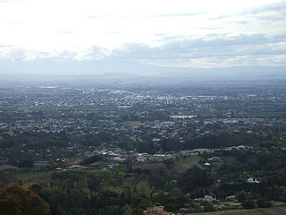
Hastings is an inland city of New Zealand and is one of the two major urban areas in Hawke's Bay, on the east coast of the North Island. The population of Hastings is 51,500, with a further 15,200 people in Havelock North and 2,090 in Clive. Hastings is about 18 kilometres inland of the coastal city of Napier. These two neighbouring cities are often called "The Bay Cities" or "The Twin Cities".

<span class="mw-page-title-main">Dannevirke</span> Town in Manawatū-Whanganui, New Zealand

Dannevirke, is a rural service town in the Manawatū-Whanganui region of the North Island, New Zealand. It is the main centre of the Tararua District.

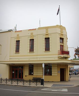
Waipukurau is the largest town in the Central Hawke's Bay District on the east coast of the North Island of New Zealand. It is located on the banks of the Tukituki River, 7 kilometres south of Waipawa and 50 kilometres southwest of Hastings.

<span class="mw-page-title-main">Tararua District</span> Territorial authority district in Manawatū-Whanganui, New Zealand

The Tararua District is a district near the south-east corner of New Zealand's North Island that is administered by the Tararua District Council. It has a population of 19,200, and an area of 4,364.65 km². The Tararua District Council was created by the amalgamation of the Dannevirke Borough, Eketahuna County Council, Pahiatua Borough Council, Pahiatua County Council and Woodville District Council in the 1989 local government reforms.

<span class="mw-page-title-main">Takapau</span> Settlement in Hawkes Bay Region, New Zealand

Takapau is a small rural community in the Central Hawkes Bay in New Zealand. It is located 20 kilometres west of Waipukurau, off State Highway 2, and has a population of more than 500.

<span class="mw-page-title-main">Manawatū District</span> Territorial authority district in New Zealand

Manawatū District is a territorial authority district in the Manawatū-Whanganui local government region in the North Island of New Zealand, administered by Manawatū District Council. It includes most of the area between the Manawatū River in the south and the Rangitīkei River in the north, stretching from slightly south of the settlement of Himatangi in the south, to just south of Mangaweka in the north, and from the Rangitīkei River to the top of the Ruahine Range in the east. It does not include the Foxton area and the mouth of the Manawatū River, or Palmerston North City. Its main town is Feilding. The district has an area of 2,624 km².

<span class="mw-page-title-main">Waipawa</span> Town in Hawkes Bay, New Zealand

Waipawa is the second-largest town in Central Hawke's Bay in the east of the North Island of New Zealand. It has a population of 2,400.

<span class="mw-page-title-main">Hastings District, New Zealand</span> Territorial authority district in Hawkes Bay Region, New Zealand

Hastings District is a Territorial authority district within the Hawke's Bay Region, on the east coast of the North Island of New Zealand. It covers the southern half of the Hawke's Bay coast, excluding Napier City, which is a separate territorial authority. Hastings District Council is headquartered in the city of Hastings, the district's largest town.

<span class="mw-page-title-main">Pōrangahau</span> Settlement in Hawkes Bay Region, New Zealand

Pōrangahau, a township close to the Pacific Ocean coast in the south-east of the North Island of New Zealand, has a very small population. It lies in the southernmost part of Hawke's Bay, 45 kilometres south of Waipukurau, and close to the mouth of the Porangahau River. The settlement includes a marae and a school.

<span class="mw-page-title-main">Ashhurst</span> Settlement in Manawatū-Whanganui Region, New Zealand

Ashhurst is a town and outlying suburb of Palmerston North, in the Manawatū-Whanganui region of New Zealand's North Island.

Bunnythorpe is a village in the Manawatū-Whanganui region of New Zealand's North Island, 10 km (6 mi) north of the region's major city, Palmerston North. Dairy farms predominate the surrounding area but the community facilities include Bunnythorpe School, with a roll of about 80 pupils as of 2010 as well as a Rugby Football Club, Country Club and several manufacturing plants. The population was 687 in the 2018 census.

Ōtāne is a town in the Central Hawke's Bay District and the Hawke's Bay region, on the east coast of New Zealand's North Island. The small village, has a school, general store, cafe and pub, and is located just off State Highway 2.

<span class="mw-page-title-main">Ongaonga, New Zealand</span> Settlement in Hawkes Bay Region, New Zealand

Ongaonga is a village in Central Hawkes Bay District of New Zealand's North Island. It is located 20 kilometres west of Waipawa and a similar distance from Waipukurau.

Whakatu is a rural community in the Hastings District and Hawke's Bay Region of New Zealand's North Island. It is located 8 kilometres (5.0 mi) north-east of the centre of Hastings. A large industrial area is enclosed by a bend in the Clive River, and the closure of the freezing works in Whakatu in 1986 cost the region 2000 full-time and seasonal jobs. State Highway 2 and the Palmerston North–Gisborne Line pass through Whakatu.

Ashley Clinton is a rural community in the Central Hawke's Bay District and Hawke's Bay Region of New Zealand's North Island.

<span class="mw-page-title-main">Ormondville</span> Settlement in Manawatū-Whanganui Region, New Zealand

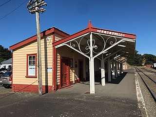
Ormondville is a locality in the Manawatū-Whanganui region of New Zealand's North Island. It is located inland, south of Waipukurau and west of Flemington, Hawke's Bay.

<span class="mw-page-title-main">Central Hawke's Bay District Council</span>

Central Hawke's Bay District Council is the territorial authority for the Central Hawke's Bay District of New Zealand. It consists of the mayor of Central Hawke's Bay, and eight councillors. The current mayor is Alex Walker.

Hatuma is 7 km (4.3 mi) south of Waipukurau, in Central Hawke's Bay in the east of the North Island of New Zealand. Meshblock 7016748, which covers 19.3 km2 (7.5 sq mi) from the edge of Waipukurau to Marakeke, had a population of 153 in 2018.

References

  1. 1 2 "ArcGIS Web Application". statsnz.maps.arcgis.com. Retrieved 5 March 2022.
  2. 1 2 3 4 "Subnational population estimates (RC, SA2), by age and sex, at 30 June 1996-2023 (2023 boundaries)". Statistics New Zealand . Retrieved 25 October 2023. (regional councils); "Subnational population estimates (TA, SA2), by age and sex, at 30 June 1996-2023 (2023 boundaries)". Statistics New Zealand . Retrieved 25 October 2023. (territorial authorities); "Subnational population estimates (urban rural), by age and sex, at 30 June 1996-2023 (2023 boundaries)". Statistics New Zealand . Retrieved 25 October 2023. (urban areas)
  3. "2013 Census About a Place: Central Hawke's Bay".
  4. "About Central Hawke's Bay". Central Hawke's Bay District. Retrieved 1 April 2021.
  5. 1 2 "Statistical area 1 dataset for 2018 Census". Statistics New Zealand. March 2020. Central Hawke's Bay District (032). 2018 Census place summary: Central Hawke's Bay District
  6. 1 2 3 "2023 Census national and subnational usually resident population counts and dwelling counts" (Microsoft Excel). Stats NZ - Tatauranga Aotearoa. Retrieved 29 May 2024.