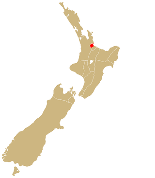
Tauranga (Māori pronunciation:[ˈtaʉɾaŋa])[3][4] is a coastal city in the Bay of Plenty Region and the fifth-most populous city of New Zealand, with an urban population of 161,800 (June 2023)[2], or roughly 3% of the national population. It was settled by Māori late in the 13th century, colonised by Europeans in the early 19th century, and was constituted as a city in 1963.[5]
The city lies in the north-western corner of the Bay of Plenty, on the south-eastern edge of Tauranga Harbour. The city extends over an area of 141.91 square kilometres (54.79sqmi), and encompasses the communities of Bethlehem, on the south-western outskirts of the city; Greerton, on the southern outskirts of the city; Matua, west of the central city overlooking Tauranga Harbour; Maungatapu; Mount Maunganui, located north of the central city across the harbour facing the Bay of Plenty; Otūmoetai; Papamoa, Tauranga's largest suburb, located in the Bay of Plenty; Tauranga City; Tauranga South; and Welcome Bay.
Tauranga is one of New Zealand's main centres for business, international trade, culture, fashion and horticultural science. The Port of Tauranga is New Zealand's largest port in terms of gross export tonnage and efficiency.[6] Tauranga is one of New Zealand's fastest-growing cities, with an 11% increase in population between the 2006 census and the 2013 census,[7] and 19% between the 2013 and 2018 census. Due to its rapid population growth, Tauranga has become New Zealand's fifth-largest city, overtaking Dunedin and the Napier-Hastings urban areas.
History
Settlement
The earliest known settlers were Māori, who arrived in the 13th century at Tauranga in the Tākitimu and the Mātaatuawaka.
In December 1826 and again in March 1827, the Herald travelled to Tauranga from the Bay of Islands to obtain supplies of potatoes, pigs and flax.[11][12] In 1835 a Church Missionary Society mission station was established at Tauranga by William Wade. Rev. Alfred N. Brown arrived at the CMS mission station in 1838.[13] John Morgan also visited the mission in 1838.[14]
View of waterfront in 1924
Europeans trading in flax were active in the Bay of Plenty during the 1830s; some were transient, others married local women and settled permanently. The first permanent non-Maori trader was James Farrow, who travelled to Tauranga in 1829, obtaining flax fibre for Australian merchants in exchange for muskets and gunpowder. Farrow acquired a land area of 2,000 square metres (1⁄2 acre) on 10 January 1838 at Otūmoetai Pā from the chiefs Tupaea, Tangimoana and Te Omanu, the earliest authenticated land purchase in the Bay of Plenty.[15]
In 1840, a Catholic mission station was established. Bishop Pompallier was given land within the palisades of Otūmoetai Pā for a church and a presbytery. The mission station closed in 1863 due to land wars in the Waikato district.[16]
New Zealand Wars–Tauranga Campaign
The Tauranga Campaign took place in and around Tauranga from 21 January to 21 June 1864, during the New Zealand Wars. The Battle of Gate Pa is the best known.
The Battle of Gate Pā was an attack on the well fortified Pā and its Māori defenders on 29 April 1864 by British forces made up of approximately 300 men of the 43rd Regiment and a naval contingent. The British casualties were 31 dead (including 10 officers), and 80 wounded - the single most devastating loss of life suffered by the British military in the whole of the New Zealand Wars. The Māori defenders abandoned the Pā during the night with casualties estimated at 25 dead and an unknown number of wounded.[17]
Fires
In November 1916, a large fire broke out at the strand destroying 12 buildings, including the Commercial Hotel.[18]
Tauranga Hotel on fire surrounded by large crowd
In 1936 another large fire occurred which started in the hotel's staff quarters and drew large crowds.[19]
Modern era
Under the Local Government (Tauranga City Council) Order 2003,[20] Tauranga became legally a city for a second time, from 1 March 2004.
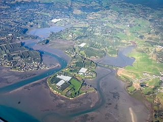
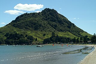
Tauranga is located around a large harbour that extends along the western Bay of Plenty, and is protected by Matakana Island and the extinct volcano of Mauao (Mount Maunganui). Ngamuwahine River is located 19 kilometres southwest of Tauranga.
View down The Strand from the intersection of Harington St in 1924, including Tauranga Hotel and the Farmers' Union Trading Company buildings
Tauranga and the Bay of Plenty are situated along a faultline and so experience (infrequent) seismic activity. There are a few volcanoes around the area (mainly dormant). The most notable of these are White Island and Mauao, nicknamed "The Mount" by locals.
During the summer months the population swells as holidaymakers descend on the city, especially along the popular white coastal surf beaches from Mount Maunganui to Papamoa.
In 1976 Tauranga was a medium-sized urban area with a population of around 48,000. However, the completion of a harbour bridge in 1988 brought Tauranga and The Mount closer (they amalgamated in 1989) and re-energised the economies of both parts of the enlarged city. By 1996 Tauranga's population had grown to 82,092 and by 2006 it had reached 103,635.[24]
In 2008 Tauranga overtook Dunedin to become the sixth-largest city in New Zealand by urban area, and the ninth largest city by Territorial Authority area. With continuing growth it has now surpassed the Napier-Hastings area to become New Zealand's fifth-largest city.
Tauranga City covers 141.91km2 (54.79sqmi)[1] and had an estimated population of 161,800 as of June 2023,[2] with a population density of 1,140 people per km2.
Tauranga had a population of 152,844 in the 2023 New Zealand census, an increase of 15,714 people (11.5%) since the 2018 census, and an increase of 37,683 people (32.7%) since the 2013 census. There were 61,842 dwellings. There were 29,604 people (19.4%) aged under 15 years, 26,316 (17.2%) aged 15 to 29, 66,792 (43.7%) aged 30 to 64, and 30,132 (19.7%) aged 65 or older.[26]
Ethnicities were 78.7% European/Pākehā, 19.3% Māori, 3.6% Pasifika, 10.3% Asian, 1.8% Middle Eastern, Latin American and African New Zealanders, and 1.0% other. People may identify with more than one ethnicity.[26]
Tauranga City had a population of 136,713 at the 2018 New Zealand census. There were 50,442 households, comprising 65,868 males and 70,845 females, giving a sex ratio of 0.93 males per female. The median age was 40.4 years (compared with 37.4 years nationally).
The proportion of people in Tauranga born overseas 21.7%, compared with 27.1% nationally. The most common birthplaces of overseas-born residents were England (5.8%), India (2.1%), South Africa (2.0%), and Australia (1.9%).
Although some people chose not to answer the census's question about religious affiliation, 50.8% had no religion, 35.5% were Christian, 2.1% had Māori religious beliefs, 1.0% were Hindu, 0.3% were Muslim, 0.5% were Buddhist and 3.1% had other religions.
Of those at least 15 years old, 21,570 (19.8%) people had a bachelor's or higher degree, and 18,957 (17.4%) people had no formal qualifications. The median income was $31,600, compared with $31,800 nationally. 17,493 people (16.0%) earned over $70,000 compared to 17.2% nationally. The employment status of those at least 15 was that 51,591 (47.3%) people were employed full-time, 16,233 (14.9%) were part-time, and 3,753 (3.4%) were unemployed.[25]
Individual wards (2018 boundaries)
Name
Area (km2)
Population
Density (per km2)
Households
Median age
Median income
Mount Maunganui-Papamoa Ward
60.98
49,785
816
18,666
40.3 years
$33,300
Otumoetai-Pyes Pa Ward
41.07
46,302
1,127
17,079
42.4 years
$32,600
Te Papa-Welcome Bay Ward
33.07
40,626
1,228
14,697
38.3 years
$28,800
New Zealand
37.4 years
$31,800
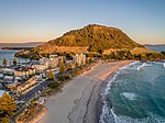
Mount Maunganui Main Beach in winter, with 'Leisure Island' in the background
Government and politics
Tauranga is located in the administrative area of the Tauranga City Council. The council consists of ten councillors and a mayor. Four councillors are elected by the city at large; the remainder are elected from three wards (constituencies), with each ward electing two councillors:
Te Papa / Welcome Bay
Otūmoetai / Pyes Pa
Mount Maunganui / Papamoa
Council elections are held every three years, most recently in 2019. In December 2020, the Minister of Local GovernmentNanaia Mahuta announced that, due to alleged "dysfunction" within the elected council, the council would be replaced by commissioners until the 2022 local elections.[27][28] However, then Tauranga MP Simon Bridges said the appointment of commissioners was unnecessary and a "dramatic and draconian step."[29] An independent review by law firm Russell McVeagh found that Mahuta's decision may have been unlawful.[30] Her decision to reappoint the crown commission for a second term in 2022 through to July 2024 was subject to a legal review by Dentons Kensington Swan who found her decision was challengeable on the grounds of unlawfulness and unreasonableness.[31]
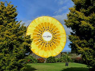
Much of the countryside surrounding Tauranga is horticultural land, used to grow a wide range of fresh produce for both domestic consumption and export. There are many kiwifruit and avocados orchards as well as other crops.
The Port of Tauranga is New Zealand's largest export port. It is a regular stop for both container ships and luxury cruise liners.
Tauranga harbourPicturesque sunrise over the Tauranga harbour
Tauranga's main shopping malls are Bayfair, in Mount Maunganui and Tauranga Crossing in Tauriko. Most of the city's shopping centres are located in the suburbs. They include Fraser Cove, Tauranga Crossing, Bethlehem Town Centre, Papamoa Plaza, Fashion Island, Bayfair Shopping Centre, Bay Central and Greerton Village.
Tauranga has the following business innovation centres
The National Jazz Festival takes place in Tauranga every Easter.[39]
Events
New Year celebrations at the Mount in Mount Maunganui are one of Tauranga's main events, bringing people from all around the country.
In 2014 Tauranga City Council granted permission for an annual Sikh parade to celebrate Guru Gobind Singh's birthday. 2500 people took part in 2014, while in 2015, the number increased to 3500.[40]
Sports
McLaren Falls Park, on the outskirts of Tauranga
Tauranga has a large stadium complex in the Mount Manganui suburb, Baypark Stadium, rebuilt in 2001 after a similar complex closed in 1995. It hosts speedway events during summer and rugby matches in winter.
Tauranga is the home to two rowing clubs – Tauranga Rowing Club in Memorial Park and Bay of Plenty Coast Rowing Club at the picturesque Wairoa River. Both clubs have had successful NZ representation over the years.
Tauranga has an all weather outdoor athletics ground at Tauranga Domain.
Tauranga also has a Hockey Association,[41] separate from the Regional Bay of Plenty body, which represents the city in domestic tournaments.
City facilities and attractions
View over Greater Tauranga, taken from the top of Mauao
Greater Tauranga is a very popular lifestyle and tourism destination. It features many natural attractions and scenery ranging from popular beaches and harbour environments to lush bush-clad mountains with waterfalls and lakes.
View of Mount Beach, with Mauao in background
Cultural attractions include the Tauranga Art Gallery, which opened in October 2007 and showcases local, national and international exhibitions in a range of media. On the 17th Avenue, the "Historic Village on 17th",[42] recreates a historic setting with original and replica buildings from early Tauranga housing arts and gift shops.
The Baycourt Community and Arts Centre is a multi-purpose performing arts and theatre facility located in the central business district.
Aviation interests are well served with the Classic Flyers Museum and the Gyrate Flying Club where you can experience flying a modern gyroplane; the "motorbike of the sky".[43]
Tauranga has many parks: one of the largest is Memorial Park, and others include Yatton Park, Kulim Park, Fergusson Park and the large Tauranga Domain. The Te Puna Quarry Park has become a regional attraction, known for being converted from a disused quarry into a community park.[44]
Due to the temperate climate, outdoor activities are very popular, including golf, tramping (hiking), mountain biking and white water rafting. The Bay of Plenty coastline has miles of golden sandy beaches, and watersports are very popular, including swimming, surfing, fishing, diving, kayaking and kitesurfing. Tourists also enjoy dolphin-watching on specially run boat trips.
The coastal suburb Papamoa and neighbouring Mount Maunganui are some of the more affluent areas in Tauranga. The region's beaches attract swimmers, surfers, kayakers and kitesurfers throughout the year.
Tauranga has many outlying islands and reefs that make it a notable tourist destination point for travelling scuba divers and marine enthusiasts.[45] Extensive marine life diversity is available to scuba divers all year round. Water temperatures range from 12 degrees Celsius in winter to 22–24 degrees Celsius in summer. Tauranga houses two professional dive instructor training centres, training NAUI, PADI and SSI dive leader systems.
Infrastructure
Tauranga Post Office
Hospitals
Tauranga Hospital is a public secondary regional hospital located in Tauranga South, with 360 beds including neonatal, geriatric, surgical, maternity and mental health care.[46] It provides elective and emergency healthcare across medical, surgical, paediatric, obstetric, gynaecological and psychiatric services. The main tertiary referral centre for Tauranga Hospital is Waikato Hospital, located in Hamilton. As the site of the Bay of Plenty Clinical School, Tauranga Hospital provides training to medical students from the University of Auckland, as well as selective and elective placements for nursing and midwifery students.[47]
Grace Hospital is Tauranga's only private specialist surgical hospital, located in Oropi. It accommodates 6 operating theatres, 48 inpatient beds, a two-bed HDU, a procedure room for minor surgery and two procedure rooms for endoscopy.[48]
Natural gas arrived in Tauranga in 1982, following the completion of the high-pressure pipeline from the Maui pipeline near Te Awamutu to the city, now operated by First Gas.[50] First Gas also operates the gas distribution network within the city.
Transport
Tauranga City Council is currently responsible for approximately 530km of roads, 700km of footpaths, cycle ways and access ways.[51]
Tauranga City Council also has a bit of work under way with their Transportation and Roads strategy. Their aim for the future to change current travel behaviour from a focus on private cars to more sustainable modes such as buses, cycling and walking.
Tauranga has no passenger rail network, however it is a busy freight rail hub due to distribution from the Port of Tauranga.
Bus
Main transportation in the city is provided by the BayBus, with twelve routes servicing the city's population. Bay Hopper buses depart the central stops in Tauranga's CBD, Ohauiti, Mount Maunganui and Bayfair every 15 minutes, with the routes to Papamoa and Greerton half-hourly.[52]Bee Cards were introduced for fares on 27 July 2020.[53]
The city is also a waypoint for bus travel between cities, with the Bay Hopper, and Intercity having a daily schedule.
Sea
Tauranga has a passenger ferry service that transports passengers from Tauranga CBD to Mount Maunganui's Salisbury wharf. It is a 2-Way service that costs $15 each way.[54][55]
The organisations currently share two main campuses, but are planning a new central campus. Stage 1 was expected to be open in 2017, catering for 500 but with capacity for 700, which cost $67.3 million.[57][58]
Pāpāmoa College, co-educational secondary school opened in 2011 for years 7–13.
Te Wharekura o Mauao,[59] a co-educational wharekura-ā-iwi total immersion Māori secondary school for Years 7–13, founded in 2010, with around 200 students.
Te Kura Kaupapa Māori o Te Kura Kōkiri, a co-educational kura kaupapa Māori total immersion school for Years 1–13, founded in 2000, with around 140 students.
The Bay of Plenty Region, often abbreviated to BOP, is a region in the North Island of New Zealand situated around the body of water of the same name. The bay was named by James Cook after he noticed the abundant food supplies at several Māori villages there, in stark contrast to the earlier observations he had made in Poverty Bay.
Rotorua is a city in the Bay of Plenty Region of New Zealand's North Island. It is sited on the southern shores of Lake Rotorua, from which it takes its name. It is the seat of the Rotorua Lakes District, a territorial authority encompassing Rotorua and several other nearby towns. It has an estimated resident population of 58,900, making it the country's 13th largest urban area, and the Bay of Plenty's second-largest urban area behind Tauranga.
Te Puke is a town located 18 kilometres southeast of Tauranga in the Western Bay of Plenty of New Zealand. It is particularly well known for the cultivation of Kiwifruit.
Matakana Island is located in the western Bay of Plenty in New Zealand's North Island. A long, flat barrier island, it is 20 kilometres (12 mi) in length but rarely more than 3 kilometres (1.9 mi) wide. The island has been continuously populated for centuries by Māori tribes that are mostly associated with Ngāi Te Rangi.
Mount Maunganui is a major residential, commercial and industrial suburb of Tauranga located on a peninsula to the north-east of Tauranga's city centre. It was an independent town from Tauranga until the completion of the Tauranga Harbour Bridge in 1988, which connects Mount Maunganui to Tauranga's central business district.
Papamoa or Papamoa Beach is a suburb of Tauranga, located about 11 kilometres from the city centre. It is the largest residential suburb in Tauranga. It is bordered to the west by Arataki and Mount Maunganui, the east by the Kaituna River and to the south by State Highway 2.
Ngāi Te Rangi or Ngāiterangi is a Māori iwi, based in Tauranga, New Zealand. Its rohe extends to Mayor Island / Tuhua and Bowentown in the north, to the Kaimai Range in the west, south of Te Puke and to Maketu in the east.
Mount Maunganui, or Mauao, known to locals as The Mount, is a dormant volcanic cone at the end of a peninsula in the Suburb of Mount Maunganui, by the eastern entrance to the Tauranga Harbour in New Zealand. It is considered very important and tapu (sacred) by the local Māori iwi, featuring extensively in local mythology. It is also of significant historical value. The summit is 232 metres above sea level.
Manawa Energy limited is a New Zealand electricity generation company that offers bespoke electricity products to commercial and industrial customers across New Zealand. Manawa energy currently operate 26 power schemes from the Bay of Plenty in the north, to Otago in the south.
Ngāti Ranginui is a Māori iwi (tribe) in Bay of Plenty, New Zealand. Its rohe extends from Waihi in the north, to the Kaimai Range in the west, to south of Te Puke in the south, and to Tauranga in the east. The rohe does not extend offshore to Matakana Island or Mayor Island / Tuhua.
Otumoetai College is a state co-educational secondary school located in Tauranga, New Zealand. The school opened in February 1965 with 206 students from years 9 to 13 to serve the western suburbs of Tauranga. Otumoetai is claimed to stand for "peaceful waters" implied by the peaceful surroundings and estuary within the Otumoetai area.
Ngāti Pūkenga is a Māori iwi centred in Tauranga in the Bay of Plenty region of New Zealand. Its rohe extends to Mayor Island / Tuhua and Waihi in the north, to the Kaimai Range in the west, south of Te Puke and to Maketu in the east, and it has tribal holdings in Whangarei, Hauraki and Maketu.
Bay of Plenty is a New Zealand electoral division returning one member to the New Zealand House of Representatives. The current representative is Tom Rutherford of the National Party, first elected at the 2023 election.
The Bay of Plenty Times is the regional daily paper for the Bay of Plenty area, including Tauranga, in the North Island of New Zealand.
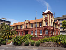
Tauranga City Council is the local government authority for Tauranga City in New Zealand. It is a territorial authority elected to represent the 158,000 people of Tauranga. The last Mayor of Tauranga was Tenby Powell, who resigned in November 2020. The council consists of 11 members elected from three wards and at-large, and is presided over by the Mayor, who is elected at large. Marty Grenfell is currently the CEO of Tauranga City Council.
Greerton is a major suburb of Tauranga, the largest city in the Bay of Plenty region of New Zealand. Greerton is named after Lieutenant-Colonel Henry Harpur Greer, commander of the British forces during the Battle of Gate Pā.
Omanu is a beach and suburb in Tauranga, in the Bay of Plenty Region of New Zealand's North Island.
Papamoa Hills Regional Park is a protected area in the Bay of Plenty Region, owned and managed by Bay of Plenty Regional Council. It is located between Papamoa and Te Puke, on Poplar Lane off State Highway 2.
The Tauranga Volcanic Centre is a geologic region in New Zealand's Bay of Plenty. It extends from the southern end of Waihi Beach and from the old volcanoes of the Coromandel Peninsula that make up the northern part of the Kaimai Range, towards the Taupō Volcanic Zone.
The 2024 Tauranga local elections will be held via postal voting from 29 June 2024 to 20 July 2024. Elections in Tauranga will cover one territorial authority, the Tauranga City Council.
↑ Cowan, James (1922). "42, Gate Pa and Te Ranga". The New Zealand Wars: A History of the Maori Campaigns and the Pioneering Period, Vol. 1, 1845–1864. Wellington: RNZ Government Printer.
This page is based on this Wikipedia article Text is available under the CC BY-SA 4.0 license; additional terms may apply. Images, videos and audio are available under their respective licenses.