Wairoa District | |
---|---|
Coordinates: 39°02′02″S177°25′23″E / 39.034°S 177.423°E | |
Country | New Zealand |
Region | Hawke's Bay Region |
Wards | Wairoa General |
Seat | Wairoa |
Government | |
• Mayor | Craig Little |
• Deputy Mayor | Denise Eaglesome-Karekare |
• Territorial authority | Wairoa District Council |
Area | |
• Total | 4,130 km2 (1,590 sq mi) |
• Land | 4,077 km2 (1,574 sq mi) |
Population (June 2023) [2] | |
• Total | 9,290 |
• Density | 2.2/km2 (5.8/sq mi) |
Time zone | UTC+12 (NZST) |
• Summer (DST) | UTC+13 (NZDT) |
Postcode(s) | |
Area code | 06 |
Website | www |
Wairoa District is a Territorial authority district in the North Island of New Zealand. The Wairoa District Council is headquartered in the largest town, Wairoa. The district falls within the Hawke's Bay Region.
The district has an area of 4,130 square kilometres, of which 4,077 square kilometres are land. [1] The population was 9,290 as of June 2023. [2]
The Wairoa District covers the northern half of the Hawke's Bay coast, and extends from Māhia Peninsula to Lake Waikaremoana, and south to the mouth of the Waikare River.
Mayor Craig Little JP was elected as mayor in the 2013 local elections. [3]
The district has been known historically as 'Te Wairoa'. In keeping with the district's vision of being bilingual by 2040, the use of the phrase 'Te Wairoa' when referring to the district is steadily increasing.[ citation needed ]Wairoa itself is Māori for "long water", referring to the length of the tranquil river that runs throughout the town. [4]
The Ruakituri River and the Māhia Peninsula are tourist destinations found in the district.
Wairoa County was established in 1876 [5] and a separate Wairoa Borough was created in 1909. [6] The two merged into the Wairoa District in the 1989 local government reforms.
In 2014, following the election of a new Council and the appointment of a new Chief Executive, the district embarked on an ambitious programme of attracting novel and high-tech industry to the district in an effort to arrest and reverse the gradual population decline and loss of services that the community had been suffering from for the previous 20 years.
A $5M investment by the central government in improved medical facilities, and, commencing July 2014, an increased emphasis by the Wairoa District Council on economic development (particularly aimed at encouragement of diversification of agribusiness, ecotourism, digital creative industry attraction, and attraction of new and returning residents) has led to an increasingly positive community view of the district's future.[ citation needed ]
As a result of these economic development efforts, in 2016, Rocket Lab announced that it was establishing its Orbital Launch Site (known as Launch Complex 1) for its Electron Vehicle on the Māhia Peninsula. The first test launch was in May 2017. The Electron vehicle is capable of delivering satellites into Low Earth Orbit, using innovative New Zealand technology. The section of Te Wairoa coastline along which satisfactory space launch viewing experiences are likely is known as 'Space Coast New Zealand' – a more modest analogue of the Florida Space Coast in the United States. The New Zealand Space Agency has been established to manage New Zealand space treaties and activity. [7]
Wairoa District covers 4,077 km2 (1,574 sq mi) [1] and had an estimated population of 9,290 as of June 2023, [2] with a population density of 2.3 people per km2.
Ethnicity | Population |
---|---|
New Zealand European | 4,140 |
Māori | 6,048 |
Pasifika | 375 |
Asian | 150 |
MELAA | 18 |
Other | 69 |
Year | Pop. | ±% p.a. |
---|---|---|
2006 | 8,484 | — |
2013 | 7,890 | −1.03% |
2018 | 8,367 | +1.18% |
2023 | 8,826 | +1.07% |
Source: [8] [9] |
Wairoa District had a population of 8,826 in the 2023 New Zealand census, an increase of 459 people (5.5%) since the 2018 census, and an increase of 936 people (11.9%) since the 2013 census. There were 4,341 dwellings. There were 2,010 people (22.8%) aged under 15 years, 1,530 (17.3%) aged 15 to 29, 3,648 (41.3%) aged 30 to 64, and 1,638 (18.6%) aged 65 or older. [9]
Ethnicities were 46.9% European/Pākehā, 68.5% Māori, 4.2% Pasifika, 1.7% Asian, 0.2% Middle Eastern, Latin American and African New Zealanders, and 0.8% other. People may identify with more than one ethnicity. [9]
Wairoa District had a population of 8,367 at the 2018 New Zealand census. There were 2,988 households, comprising 4,194 males and 4,173 females, giving a sex ratio of 1.01 males per female. The median age was 38.6 years (compared with 37.4 years nationally).
The percentage of people born overseas was 6.8, compared with 27.1% nationally.
Although some people chose not to answer the census's question about religious affiliation, 36.1% had no religion, 41.1% were Christian, 13.1% had Māori religious beliefs, 0.1% were Hindu, 0.5% were Muslim, 0.3% were Buddhist and 0.9% had other religions.
Of those at least 15 years old, 609 (9.5%) people had a bachelor's or higher degree, and 1,740 (27.2%) people had no formal qualifications. The median income was $22,600, compared with $31,800 nationally. 465 people (7.3%) earned over $70,000 compared to 17.2% nationally. The employment status of those at least 15 was that 2,682 (41.9%) people were employed full-time, 945 (14.8%) were part-time, and 459 (7.2%) were unemployed. [8]
Name | Population | Households | Median age | Median income |
---|---|---|---|---|
Maungataniwha-Raupunga | 1,188 | 405 | 35 years | $25,000 [10] |
Frasertown-Ruakituri | 861 | 324 | 39 years | $28,700 [11] |
Whakaki | 675 | 255 | 44.8 years | $24,000 [12] |
Wairoa | 4,527 | 1,548 | 36.4 years | $21,500 [13] |
Mahia | 1,119 | 456 | 49 years | $21,400 [14] |
New Zealand | 37.4 years | $31,800 |
Wairoa has one mainstream secondary school, Wairoa College, which caters for students between the years of 7 and 13. Te Kura Kaupapa Māori O Ngati Kahungunu O Te Wairoa is a composite school providing for years 1 to 13, teaching in the Māori language
Wairoa Primary, Tiaho, and Frasertown are the primary schools that offer education to students in years 1 to 6. Ohuka, Te Mahia, Nuhaka, Ruakituri, Mohaka, Waikaremoana, Tiniroto, Tutira, Kotemaori, and St Joseph's School offer education to students in the years 1 to 8. The latter is a special Catholic character school.
Hawke's Bay is a region on the east coast of New Zealand's North Island. The region is named for Hawke Bay, which was named in honour of Edward Hawke. The region's main centres are the cities of Napier and Hastings, while the more rural parts of the region are served by the towns of Waipukurau, Waipawa, and Wairoa.
Kaipara District is a territorial authority district in the Northland Region of New Zealand.
Hauraki District is a territorial authority governed by the Hauraki District Council within the Hauraki region of New Zealand. The seat of the council is at Paeroa.
Wairoa is a town and territorial authority district in New Zealand's North Island. The town is the northernmost in the Hawke's Bay region, and is located on the northern shore of Hawke Bay at the mouth of the Wairoa River and to the west of Māhia Peninsula. It is on State Highway 2, 118 kilometres (73 mi) northeast of Napier, and 92 kilometres (57 mi) southwest of Gisborne. Wairoa is the nearest town to the Te Urewera protected area and former national park that is accessible from Wairoa via State Highway 38. It is the largest town in the district of Wairoa, and is one of three towns in New Zealand, the others being Kawerau and Ōpōtiki, where Māori outnumber other ethnicities, with 62.29% of the population identifying as Māori.
Māhia Peninsula is located on the east coast of New Zealand's North Island, in the Hawke's Bay region, between the towns of Wairoa and Gisborne.
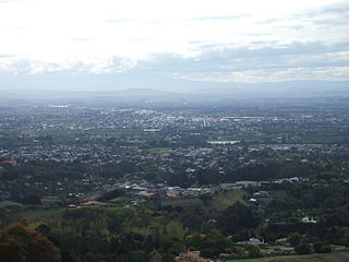
Hastings District is a Territorial authority district within the Hawke's Bay Region, on the east coast of the North Island of New Zealand. It covers the southern half of the Hawke's Bay coast, excluding Napier City, which is a separate territorial authority. Hastings District Council is headquartered in the city of Hastings, the district's largest town.
Clevedon, previously known as Wairoa South, is a rural town to the south-east of Auckland, New Zealand, in the local government area of Franklin. The area is part of the rohe of Ngāi Tai ki Tāmaki, who settled around the Wairoa River. The original township was founded in the 1850s, and was named Clevedon in 1866. Over time, it has developed into a centre for the dairy industry south-east of Auckland.
Ruapehu District is a territorial authority in the centre of New Zealand's North Island.
Ōtāne is a town in the Central Hawke's Bay District and the Hawke's Bay region, on the east coast of New Zealand's North Island. The small village, has a school, general store, cafe and pub, and is located just off State Highway 2.
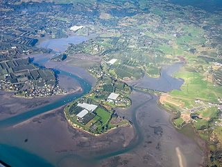
The Wairoa River of the Hawke's Bay region in New Zealand runs south for 65 kilometres from the inland east coast region of the North Island, west of Gisborne, before flowing into northern Hawke Bay at the town of Wairoa.
Kaeo is a township in the Far North District of New Zealand, located some 22 km (14 mi) northwest of Kerikeri. The town's name comes from the Māori-language name of the New Zealand freshwater mussel, which is found in nearby rivers.
Nūhaka is a small settlement in the northern Hawke's Bay Region of New Zealand's eastern North Island, lying on State Highway 2 between Wairoa and Gisborne. The road to Mahia turns off the highway at Nūhaka.
Frasertown is a small settlement in the northern Hawke's Bay Region of New Zealand's eastern North Island.
Gisborne District or the Gisborne Region is a local government area of northeastern New Zealand. It is governed by Gisborne District Council, a unitary authority. It is named after its largest settlement, the city of Gisborne. The region is also commonly referred to as the East Coast.
Mārahau is a village in the Tasman District of the South Island of New Zealand, approximately 19 kilometres (12 mi) north of Motueka. Its location on Tasman Bay and at the southern entrance of the Abel Tasman National Park makes it a popular holiday destination for those keen on outdoor activities. People access the Abel Tasman from Mārahau by tramping, kayaking and water taxi. In Mārahau itself, the beach offers sheltered and safe swimming, and horse trekking is popular throughout the busy summer season.
Hihi or Hihi Beach is a village and rural community in the Far North District and Northland Region of New Zealand's North Island.
Waitahanui is a village in the Taupō District, Waikato region, New Zealand. The village is on the eastern shore of Lake Taupō, 14 km (9 mi) south of the district seat of Taupō.
Tuai is a village and rural community located around Lake Whakamarino, in the Wairoa District of the Hawke's Bay Region, on New Zealand's North Island.
Point Wells is a rural settlement in the Auckland Region of New Zealand, at the tip of a peninsula between the Ōmaha River and Whangateau Harbour. Ōmaha is across the harbour but accessible by a causeway.
Plummers Point is a rural settlement in the Western Bay of Plenty District and Bay of Plenty Region of New Zealand's North Island. It is on a headland on the southern side of Tauranga Harbour, opposite Motuhoa Island, and between Mangawhai Bay and Te Puna Estuary. The East Coast Main Trunk forms its southern boundary.