Ruapehu District

Last updated
Ruapehu District
Ruapehu Through The Haze And Cloud - Flickr - Geoff J Mckay.jpg
Ruapehu DC.PNG
Location of the Ruapehu District
Coordinates: 38°48′14″S175°15′43″E / 38.804°S 175.262°E / -38.804; 175.262
CountryNew Zealand
Island North Island
Region Manawatū-Whanganui
Wards
  • Ōhura
  • Taumarunui
  • National Park
  • Waimarino-Waiouru
Named for Mount Ruapehu
Seat Taumarunui
Towns
Government
  MayorWeston Kirton
  Deputy MayorVivienne Hoeta
  Chief ExecutiveClive Manley
   Territorial authority Ruapehu District Council
Area
[1]
  Land6,734.41 km2 (2,600.17 sq mi)
Highest elevation
2,797 m (9,177 ft)
Population
 (June 2023) [2]
  Total13,050
Time zone UTC+12 (NZST)
  Summer (DST) UTC+13 (NZDT)
Area code(s) 07 (northern and central)
06 (southern)
Website www.ruapehudc.govt.nz OOjs UI icon edit-ltr-progressive.svg

Ruapehu District is a territorial authority in the centre of New Zealand's North Island.

Contents

It has an area of 6,734 square kilometers and the district's population in June 2023 was 13,050. [2]

Features

The district is landlocked, and contains the western half of the Tongariro National Park, including Mount Ruapehu and the western sides of Mount Ngauruhoe and Mount Tongariro, as well as part of the Whanganui National Park. The district is also home to the world-famous Raurimu Spiral on the North Island Main Trunk railway line.

The tourist towns of Raetihi, Whakapapa Village, National Park, and Ohakune are located near Mount Ruapehu in the south-east of the district. Waiouru, with an elevation of 815 metres, is in the extreme south-east of the district and houses the large Waiouru Army Camp. The southern section of the infamous Desert Road section of State Highway 1 runs through the east of the district, from Waiouru to Rangipo.

Demographics

Ruapehu District covers 6,734.41 km2 (2,600.17 sq mi) [1] and had an estimated population of 13,050 as of June 2023, [2] with a population density of 1.9 people per km2.

Historical population
YearPop.±% p.a.
200613,572    
201311,844−1.93%
201812,309+0.77%
202313,095+1.25%
Source: [3] [4]
Ethnicities, 2023 Census
EthnicityPopulation
New Zealand European
9,009
Māori
5,979
Pasifika
456
Asian
474
MELAA
81
Other
153

Ruapehu District had a population of 13,095 in the 2023 New Zealand census, an increase of 786 people (6.4%) since the 2018 census, and an increase of 1,251 people (10.6%) since the 2013 census. There were 7,962 dwellings. There were 2,802 people (21.4%) aged under 15 years, 2,217 (16.9%) aged 15 to 29, 5,691 (43.5%) aged 30 to 64, and 2,388 (18.2%) aged 65 or older. [4]

Ethnicities were 68.8% European/Pākehā, 45.7% Māori, 3.5% Pasifika, 3.6% Asian, 0.6% Middle Eastern, Latin American and African New Zealanders, and 1.2% other. People may identify with more than one ethnicity. [4]

Ruapehu District had a population of 12,309 at the 2018 New Zealand census. There were 4,617 households, comprising 6,288 males and 6,021 females, giving a sex ratio of 1.04 males per female. The median age was 39.0 years (compared with 37.4 years nationally)

The percentage of people born overseas was 10.4, compared with 27.1% nationally.

Although some people chose not to answer the census's question about religious affiliation, 51.1% had no religion, 33.0% were Christian, 5.1% had Māori religious beliefs, 0.7% were Hindu, 0.1% were Muslim, 0.5% were Buddhist and 1.4% had other religions.

Of those at least 15 years old, 1,026 (10.7%) people had a bachelor's or higher degree, and 2,466 (25.7%) people had no formal qualifications. The median income was $25,300, compared with $31,800 nationally. 948 people (9.9%) earned over $70,000 compared to 17.2% nationally. The employment status of those at least 15 was that 4,719 (49.2%) people were employed full-time, 1,431 (14.9%) were part-time, and 483 (5.0%) were unemployed. [3]

Individual statistical areas
NameArea (km2)PopulationDensity (per km2)HouseholdsMedian ageMedian income
Ohura Ward2,011.701,0200.5142343.4 years$27,300
Taumarunui Ward635.495,9739.402,28342.1 years$22,200
National Park Ward1,375.291,0500.7641141.3 years$30,800
Waimarino-Waiouru Ward2,711.944,2601.571,50034.5 years$31,500
New Zealand37.4 years$31,800

Governmental

Cattle in Ruapehu District along Ruatiti Road Cattle in Ruapehu District along Ruatiti Road.JPG
Cattle in Ruapehu District along Ruatiti Road

Ruapehu District Council

The Ruapehu District Council was established by the 1989 local government reforms. It was formed from the Taumarunui Borough Council, Taumarunui County Council, Waimarino District Council and parts of the Rangitikei County, Taupo District, Waitomo District and Stratford District councils. [5]

The council is made up of 12 elected councillors, including a mayor and deputy mayor. The district is also served by 2 Community Boards and a Ward Committee, with the same functions and powers as the Community Boards.

Mayor

The current mayor of the Ruapehu District is Weston Kirton, the deputy mayor is Vivienne Hoeta.

Council

  • Taumarunui-Ohura Community Board; 5 elected community representatives and 1 appointed Councillor.
  • Waimarino-Waiouru Community Board; 5 elected community representatives and 1 appointed Councillor.
  • Owhango-National Park Community Board; 5 elected community representatives and 1 appointed Councilor.

Related Research Articles

<span class="mw-page-title-main">North Island</span> One of the two main New Zealand islands

The North Island, also officially named Te Ika-a-Māui, is one of the two main islands of New Zealand, separated from the larger but less populous South Island by Cook Strait. With an area of 113,729 km2 (43,911 sq mi), it is the world's 14th-largest island, constituting 43% of New Zealand's land area. It has a population of 3,997,300, which is 77% of New Zealand's residents, making it the most populous island in Polynesia and the 28th-most-populous island in the world.

<span class="mw-page-title-main">Manawatū-Whanganui</span> Region of New Zealand

Manawatū-Whanganui is a region in the lower half of the North Island of New Zealand, whose main population centres are the cities of Palmerston North and Whanganui. It is administered by the Manawatū-Whanganui Regional Council, which operates under the name Horizons Regional Council.

<span class="mw-page-title-main">Tūrangi</span> Town in Waikato, New Zealand

Tūrangi is a small town on the west bank of the Tongariro River, 50 kilometres south-west of Taupō on the North Island Volcanic Plateau of New Zealand. It was built to accommodate the workers associated with the Tongariro hydro-electric power development project and their families. The town was designed to remain as a small servicing centre for the exotic forest plantations south of Lake Taupō and for tourists. It is well known for its trout fishing and calls itself "the trout fishing capital of the world". The major Māori hapū (tribe) of the Tūrangi area is Ngāti Tūrangitukua.

<span class="mw-page-title-main">Taumarunui</span> Town in Manawatū-Whanganui Region, New Zealand

Taumarunui is a small town in the King Country of the central North Island of New Zealand. It is on an alluvial plain set within rugged terrain on the upper reaches of the Whanganui River, 65 km south of Te Kūiti and 55 km west of Tūrangi. It is under the jurisdiction of Ruapehu District and Manawatū-Whanganui region.

<span class="mw-page-title-main">National Park, New Zealand</span> Settlement in Manawatū-Whanganui Region, New Zealand

National Park is a small town on the North Island Central Plateau in New Zealand. Also known as National Park Village, it is the highest urban township in New Zealand, at 825 metres. The village has great views of Mount Tongariro, Mount Ngauruhoe, and Mount Ruapehu.

<span class="mw-page-title-main">Thames-Coromandel District</span> Territorial authority district in Waikato, New Zealand

The Thames-Coromandel District is a territorial authority district in the North Island of New Zealand, covering all the Coromandel Peninsula and extending south to Hikutaia.

<span class="mw-page-title-main">South Waikato District</span> Territorial authority district in Waikato, New Zealand

South Waikato District is a local government district in the Waikato Region of the North Island of New Zealand. It is located between the cities of Hamilton to the north, Rotorua to the east, Taupo to the south and Ruapehu District to the west.

<span class="mw-page-title-main">Ohakune</span> Town in Manawatū-Whanganui, New Zealand

Ohakune is a small town at the southern end of Tongariro National Park, close to the southwestern slopes of the active volcano Mount Ruapehu, in the North Island of New Zealand.

<span class="mw-page-title-main">Raetihi</span> Town in Manawatū-Whanganui, New Zealand

Raetihi, a small town in the centre of New Zealand's North Island, is located at the junction of State Highways 4 and 49 in the Manawatū-Whanganui region. It lies in a valley between Tongariro and Whanganui National Parks, 11 kilometres west of Ohakune's ski fields.

<span class="mw-page-title-main">Buller District</span> Territorial authority district in West Coast Region, New Zealand

Buller District is one of 53 districts of New Zealand, and is within the West Coast Region. It covers Westport, Karamea, Reefton and Inangahua Junction.

<span class="mw-page-title-main">Ōwhango</span> Settlement in Manawatū-Whanganui Region, New Zealand

Ōwhango is a small town in New Zealand situated about 20 kilometres (12 mi) south of Taumarunui on State Highway 4 (SH4), and about 2 kilometres (1.2 mi) west of the Whakapapa River, a tributary of the nascent Whanganui River.

Taupō District Council is a territorial authority that administers the Taupō District in the Central North Island of New Zealand. The district stretches from the small town of Mangakino in the northwest to the Tongariro National Park in the south, and east into the Kaingaroa Forest, covering 6,970 km2. It had a population of as of June 2023.

<span class="mw-page-title-main">Taupō District</span> District in New Zealand

Taupō District is a territorial authority district in New Zealand. It covers 6,333 km² of land, and a further 610 km² of lake area, including Lake Taupō, New Zealand's largest lake, and Lake Rotoaira. The district stretches from the small town of Mangakino in the northwest to the Tongariro National Park in the south, and east into the Kaingaroa Forest. The district's population is largely located in the two main centres, Taupō and Tūrangi.

<span class="mw-page-title-main">Pukawa</span> Settlement in Waikato, New Zealand

Pukawa or Pukawa Bay is a bay and a small township on the southern shores of Lake Taupō on New Zealand's North Island. It is off State Highway 41 between Turangi and Taumarunui, in the Taupō District and Waikato region.

<span class="mw-page-title-main">Rangataua</span> Settlement in Manawatū-Whanganui Region, New Zealand

Rangataua is a small village in the North Island of New Zealand. It is located at the southern end of both the Tongariro National Park and Rangataua State Forest, adjacent to the southwestern slopes of the active volcano Mount Ruapehu. Part of the Manawatū-Whanganui region, the town is 5 kilometres east of Ohakune, 75 kilometres northeast of Wanganui, and 20 kilometres west of Waiouru.

<span class="mw-page-title-main">Gore District, New Zealand</span> Territorial authority district in Southland, New Zealand

Gore District is a district in the Southland Region of the South Island of New Zealand. It is named for Gore, the district's biggest township.

<span class="mw-page-title-main">Whanganui District</span> Territorial authority district in Manawatū-Whanganui, New Zealand

Whanganui District is one of the districts of New Zealand. It includes the city of Whanganui and surrounding areas.

<span class="mw-page-title-main">Raurimu</span> Settlement in Manawatū-Whanganui Region, New Zealand

Raurimu is a settlement in Ruapehu District, New Zealand. State Highway 4 passes through it, and the North Island Main Trunk railway line runs to the east. The Raurimu Spiral, which allows the railway to climb 139 metres, is described as an engineering masterpiece by the Institute of Professional Engineers of New Zealand.

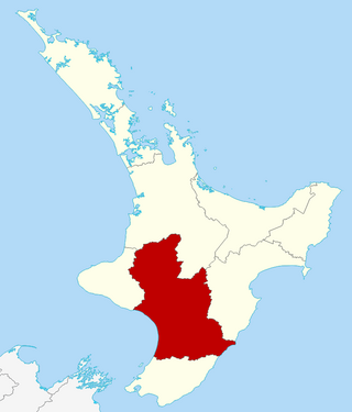
Ruapehu District Council is the territorial authority for the Ruapehu District of New Zealand.

<span class="mw-page-title-main">Whakatāne District</span> Territorial authority district in Bay of Plenty, New Zealand

Whakatāne District is a territorial authority district on the North Island of New Zealand. The Whakatāne District Council is headquartered in the largest town, Whakatāne. The district falls within the Bay of Plenty Region. Victor Luca has been the mayor of Whakatāne since the 2022 local elections.

References

  1. 1 2 "ArcGIS Web Application". statsnz.maps.arcgis.com. Retrieved 5 March 2022.
  2. 1 2 3 "Subnational population estimates (RC, SA2), by age and sex, at 30 June 1996-2023 (2023 boundaries)". Statistics New Zealand . Retrieved 25 October 2023. (regional councils); "Subnational population estimates (TA, SA2), by age and sex, at 30 June 1996-2023 (2023 boundaries)". Statistics New Zealand . Retrieved 25 October 2023. (territorial authorities); "Subnational population estimates (urban rural), by age and sex, at 30 June 1996-2023 (2023 boundaries)". Statistics New Zealand . Retrieved 25 October 2023. (urban areas)
  3. 1 2 "Statistical area 1 dataset for 2018 Census". Statistics New Zealand. March 2020. Ruapehu District (036). 2018 Census place summary: Ruapehu District
  4. 1 2 3 "2023 Census national and subnational usually resident population counts and dwelling counts" (Microsoft Excel). Stats NZ - Tatauranga Aotearoa. Retrieved 29 May 2024.
  5. "Ruapehu District Council". Archives Central. 23 April 2014. Retrieved 21 July 2019.