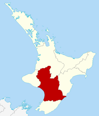
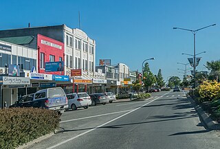
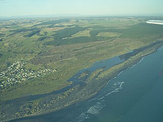
Whanganui District

Last updated

Whanganui District
Main Whanganui River Bridge View from Helicopter - panoramio.jpg
Whanganui River Bridge View from Helicopter
Whanganui DC.png
Coordinates: 39°38′S175°08′E / 39.64°S 175.14°E / -39.64; 175.14
Country New Zealand
Region Manawatū-Whanganui
Seat Whanganui
Government
  MayorAndrew Tripe
  Deputy MayorHelen Craig
   Territorial authority Whanganui District Council
Area
[1]
  Land2,373.27 km2 (916.32 sq mi)
Population
 (June 2023) [2]
  Total48,900
Time zone UTC+12 (NZST)
  Summer (DST) UTC+13 (NZDT)
Postcode(s)
Website www.whanganui.govt.nz OOjs UI icon edit-ltr-progressive.svg

Whanganui District is one of the districts of New Zealand. It includes the city of Whanganui and surrounding areas.

Contents

Geography

Formerly spelled "Wanganui", the Whanganui District Council resulted from the amalgamation of Wanganui and Waitotara county councils and Wanganui City Council. The district has an area of 2,373 km². Much of the land in Whanganui District is rough hill country surrounding the valley of the Whanganui River. A large proportion of this is within the Whanganui National Park.

In 2015 the New Zealand Geographic Board, at the request of the Wanganui District Council, changed the name of the district from Wanganui District to Whanganui District, bringing the name in line with the spelling of the river. [3]

Demographics

Whanganui District covers 2,373.27 km2 (916.32 sq mi) [1] and had an estimated population of 48,900 as of June 2023, [2] with a population density of 21 people per km2. All but some 6,100 people in the Whanganui District live in the city itself, meaning there are few prominent outlying settlements. A small but notable village is Jerusalem.

Historical population
YearPop.±% p.a.
200642,636    
201342,153−0.16%
201845,309+1.45%
202347,619+1.00%
Source: [4] [5]
Ethnicities, 2023 Census
EthnicityPopulation
New Zealand European
37,284
Māori
13,566
Pasifika
1,965
Asian
2,415
MELAA
270
Other
669

Whanganui District had a population of 47,619 in the 2023 New Zealand census, an increase of 2,310 people (5.1%) since the 2018 census, and an increase of 5,466 people (13.0%) since the 2013 census. There were 20,679 dwellings. There were 9,042 people (19.0%) aged under 15 years, 7,773 (16.3%) aged 15 to 29, 20,202 (42.4%) aged 30 to 64, and 10,599 (22.3%) aged 65 or older. [5]

Ethnicities were 78.3% European/Pākehā, 28.5% Māori, 4.1% Pasifika, 5.1% Asian, 0.6% Middle Eastern, Latin American and African New Zealanders, and 1.4% other. People may identify with more than one ethnicity. [5]

Whanganui District had a population of 45,309 at the 2018 New Zealand census. There were 18,057 households, comprising 21,912 males and 23,397 females, giving a sex ratio of 0.94 males per female. The median age was 43.0 years (compared with 37.4 years nationally).

The percentage of people born overseas was 12.3, compared with 27.1% nationally.

Although some people chose not to answer the census's question about religious affiliation, 48.3% had no religion, 37.3% were Christian, 3.3% had Māori religious beliefs, 0.6% were Hindu, 0.3% were Muslim, 0.4% were Buddhist and 1.8% had other religions.

Of those at least 15 years old, 5,130 (14.1%) people had a bachelor's or higher degree, and 8,427 (23.2%) people had no formal qualifications. The median income was $24,400, compared with $31,800 nationally. 3,300 people (9.1%) earned over $70,000 compared to 17.2% nationally. The employment status of those at least 15 was that 15,159 (41.7%) people were employed full-time, 5,406 (14.9%) were part-time, and 1,866 (5.1%) were unemployed. [4]

Related Research Articles

<span class="mw-page-title-main">Coromandel, New Zealand</span> Town in Waikato, New Zealand

Coromandel, also called Coromandel Town to distinguish it from the wider district, is a town on the Coromandel Harbour, on the western side of the Coromandel Peninsula, which is in the North Island of New Zealand. It is 75 kilometres east of the city of Auckland, although the road between them, which winds around the Firth of Thames and Hauraki Gulf coasts, is 190 km long. The population was 1,930 as of June 2023.

<span class="mw-page-title-main">Manawatū-Whanganui</span> Region of New Zealand

Manawatū-Whanganui is a region in the lower half of the North Island of New Zealand, whose main population centres are the cities of Palmerston North and Whanganui. It is administered by the Manawatū-Whanganui Regional Council, which operates under the name Horizons Regional Council.

<span class="mw-page-title-main">Horowhenua District</span> Territorial authority district in Manawatū-Whanganui, New Zealand

Horowhenua District is a territorial authority district on the west coast of the North Island of New Zealand, administered by Horowhenua District Council. Located north of Wellington and Kāpiti, it stretches from slightly north of the town of Ōtaki in the south to just south of Himatangi in the north, and from the coast to the top of the Tararua Range. It is in the Manawatū-Whanganui local government region. The name Horowhenua is Māori for landslide.

<span class="mw-page-title-main">Hauraki District</span> Territorial authority district in Waikato Region, New Zealand

Hauraki District is a territorial authority governed by the Hauraki District Council within the Hauraki region of New Zealand. The seat of the council is at Paeroa.

<span class="mw-page-title-main">Waitomo District</span> Territorial authority district in Waikato region, New Zealand

Waitomo District is a territorial authority, located in the Waikato region, at the north of the King Country area in the North Island of New Zealand. A small part of the district, the locality of Tiroa, however, lies in the Manawatū-Whanganui region.

<span class="mw-page-title-main">Tararua District</span> Territorial authority district in Manawatū-Whanganui, New Zealand

The Tararua District is a district near the south-east corner of New Zealand's North Island that is administered by the Tararua District Council. It has a population of 19,200, and an area of 4,364.65 km². The Tararua District Council was created by the amalgamation of the Dannevirke Borough, Eketahuna County Council, Pahiatua Borough Council, Pahiatua County Council and Woodville District Council in the 1989 local government reforms.

<span class="mw-page-title-main">Waverley, Taranaki</span> Settlement in Taranaki Region, New Zealand

Waverley is a town located in the South Taranaki District in New Zealand. It is 44 km northwest of Whanganui. Patea is 17 km to the west, and Waitōtara is 10 km to the southeast. State Highway 3 and the Marton - New Plymouth Line railway run through the town.

<span class="mw-page-title-main">Ashhurst</span> Settlement in Manawatū-Whanganui Region, New Zealand

Ashhurst is a town and outlying suburb of Palmerston North, in the Manawatū-Whanganui region of New Zealand's North Island.

<span class="mw-page-title-main">Buller District</span> Territorial authority district in West Coast Region, New Zealand

Buller District is one of 53 districts of New Zealand, and is within the West Coast Region. It covers Westport, Karamea, Reefton and Inangahua Junction.

<span class="mw-page-title-main">Ruapehu District</span> Territorial authority district in North Island, New Zealand

Ruapehu District is a territorial authority in the centre of New Zealand's North Island.

<span class="mw-page-title-main">Taupō District</span> District in New Zealand

Taupō District is a territorial authority district in New Zealand. It covers 6,333 km² of land, and a further 610 km² of lake area, including Lake Taupō, New Zealand's largest lake, and Lake Rotoaira. The district stretches from the small town of Mangakino in the northwest to the Tongariro National Park in the south, and east into the Kaingaroa Forest. The district's population is largely located in the two main centres, Taupō and Tūrangi.

<span class="mw-page-title-main">Rātana Pā</span> Settlement in Manawatū-Whanganui Region, New Zealand

Rātana Pā, or Ratana Community, is a town in the North Island of New Zealand, near Whanganui and Marton in the Manawatū-Whanganui region. The locality was the farm of Tahupōtiki Wiremu Rātana, the founder of a Maori religious and political movement, and the settlement developed in the 1920s as followers came to see Rātana. It continues as the centre of the Rātana Church. Due to the importance of the Rātana movement in New Zealand politics, leading New Zealand politicians often attend annual gatherings at Rātana Pā.

Waitōtara is a town in South Taranaki, New Zealand. Waverley is 10 km to the north-west, and Whanganui is 34 km to the south-east. State Highway 3 passes through it. The Waitōtara River flows past the east side of the town.

<span class="mw-page-title-main">Rangataua</span> Settlement in Manawatū-Whanganui Region, New Zealand

Rangataua is a small village in the North Island of New Zealand. It is located at the southern end of both the Tongariro National Park and Rangataua State Forest, adjacent to the southwestern slopes of the active volcano Mount Ruapehu. Part of the Manawatū-Whanganui region, the town is 5 kilometres east of Ohakune, 75 kilometres northeast of Wanganui, and 20 kilometres west of Waiouru.

<span class="mw-page-title-main">Gore District, New Zealand</span> Territorial authority district in Southland, New Zealand

Gore District is a district in the Southland Region of the South Island of New Zealand. It is named for Gore, the district's biggest township.

Himatangi Beach is a small coastal community in the Manawatū-Whanganui region of New Zealand's North Island. It is located 32 kilometres west of Palmerston North in the centre of the largest sand dune geographical feature in New Zealand.

<span class="mw-page-title-main">Koitiata</span> Settlement in Manawatū-Whanganui Region, New Zealand

Koitiata is a settlement located in the southwestern part of Rangitikei District of the Manawatū-Whanganui region of New Zealand's North Island. At the time of the 2018 census, Koitiata had a population of 126. Marton is located 24 km to the east and Whanganui is located 29 km to the northwest. Nearby Koitiata is Lake Koitiata.

<span class="mw-page-title-main">Kai Iwi</span> Settlement in Manawatū-Whanganui, New Zealand

Kai Iwi is a rural community west of Whanganui in New Zealand's North Island. It lies close to SH 3, approximately halfway between Whanganui and Waitotara. The population centre is at Kai Iwi Beach, also called Mowhanau.

Hokio Beach or Hōkio is a village and rural community in the Horowhenua District and Manawatū-Whanganui region of New Zealand's North Island.

Waiinu Beach is a settlement on the South Taranaki Bight in South Taranaki, New Zealand. Waverley is 18.5 km to the north-west by road, and Whanganui is 42 km to the south-east.

References

  1. 1 2 "ArcGIS Web Application". statsnz.maps.arcgis.com. Retrieved 5 March 2022.
  2. 1 2 "Subnational population estimates (RC, SA2), by age and sex, at 30 June 1996-2023 (2023 boundaries)". Statistics New Zealand . Retrieved 25 October 2023. (regional councils); "Subnational population estimates (TA, SA2), by age and sex, at 30 June 1996-2023 (2023 boundaries)". Statistics New Zealand . Retrieved 25 October 2023. (territorial authorities); "Subnational population estimates (urban rural), by age and sex, at 30 June 1996-2023 (2023 boundaries)". Statistics New Zealand . Retrieved 25 October 2023. (urban areas)
  3. Sachdeva, Sam (17 November 2015). "Wanganui to become Whanganui". Stuff . Retrieved 6 January 2016.
  4. 1 2 "Statistical area 1 dataset for 2018 Census". Statistics New Zealand. March 2020. Whanganui District (037). 2018 Census place summary: Whanganui District
  5. 1 2 3 "2023 Census national and subnational usually resident population counts and dwelling counts" (Microsoft Excel). Stats NZ - Tatauranga Aotearoa. Retrieved 29 May 2024.